The Tang Shipwreck and Orkney Simmens

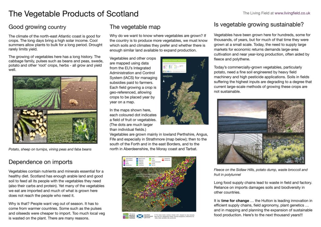
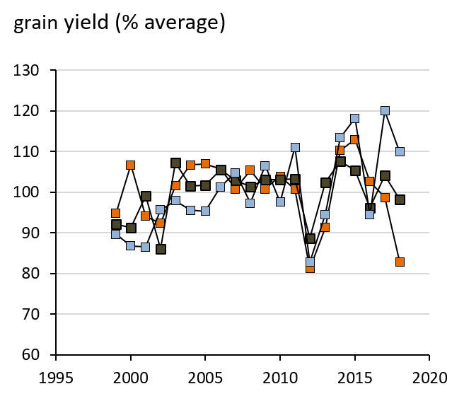
Examples of plant fibre and plant parts used in construction: coir from the husks of the coconut, simmens and sookens from oat straw. The Tang Shipwreck, found in the Java Sea, its hull planks sewn with coir. House roofs in Orkney protected and insulated with oat rope. Traditional uses of unprocessed plant material brought to life through museums in Singapore and Orkney.

Coconut fibre binds 9thC wooden hulled ship

The Asian Civilisations Museum in Singapore [1] hosts a major exhibition on the Tang Shipwreck, found in 1998 in the Java sea [2]. The ship carried pottery before it sank, including many porcelain bowls made during the Tang Dynasty of China (618-907), far to the east of its resting place, and intended for export and sale to the middle east. They were decorated with homely designs, trees and flowers, but also fantastic sea creatures and other beasts (Fig. 1).

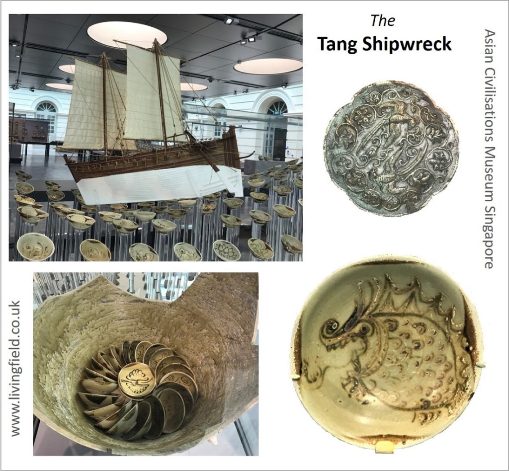
Fig. 1 Images of the Tang Shipwreck: a replica of the ship among examples of pottery; (upper right) a silver medallion; (lower right) bowl with fantastic sea monster; (lower left) a large pot in which many individual bowls were packed. From Asian Civilisations Museum, Singapore (www.livingfield.co.uk).

It is not so much the surviving pottery and coins that caught the interest of the Living Field‘s roving reporters, but the way the ship’s hull was constructed. It was made of wooden planks, but they were not nailed or bound by iron. Rather they appear to have had holes bored in them through which coir fibre was passed to sew the planks together. The joints were bound with wadding and sealed with lime. The guidebook states ‘these techniques are typical of early ships made in the region of the (Arabian or Persian) Gulf and India’ [2].

The Tang ship was recreated using techniques as in the original and proved seaworthy during trials in 2010.

What of coir?

Coir comes from the husks of the coconut fruit [3]. The durability of coir can be seen in the many coconuts that are washed up on beaches throughout the region. Strands of the fibrous content of the husk appear clearer when the coconut has long exposure to salt water, during which the natural packing material disintegrates, allowing the coarse fibre to fall free.

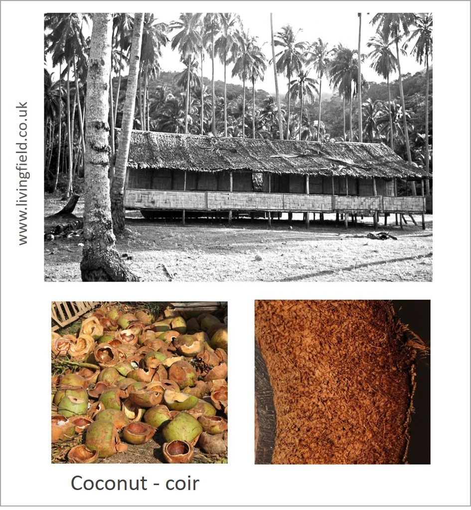
Fig. 2 Coconut grove and palm-thatched hut typical on shores of the South China Sea (taken 1980s), discarded coconuts after food extracted (lower left), and part of a coconut in cross section showing the band of fibre about 5 cm wide (coir) between the inner kernel and the outer skin (www.curvedflatlands.co.uk).

Coconut Cocos nucifera is one of the most useful plants [3]: as food, drink, oil, medicinal, fermented alcohol, utensil, animal feed, fuel, roofing material, and more. In Europe, its flesh or ‘meat’ is widely used in oriental cooking, but more common is the coir fibre used to make mats and matting . The fibre surrounds the ‘nut’, the whole protected by an outer skin. More recent uses include the fibrous ‘compost’ in which some protected fruit crops are grown.

Orkney Simmens and sookens – oat rope

At that time of the Tang shipwreck, the Picts in Scotland were carving stones and cross-slabs, reaching a high point in European Celtic art. Like the Tang potters, they also depicted fabulous monsters. Little is known of how they built their ships, but there is no equivalent of coir here, nothing quite so strong and durable that grows ready-made on trees, except perhaps the stems of heather and worked willow.

A material moderately strong and durable was however used to make rope, and that was straw from the oat crop. The distant origins of oat-rope are uncertain, but it was still in use until recently in Orkney where it was called simmens, used in roofing and securing hay ricks [4].

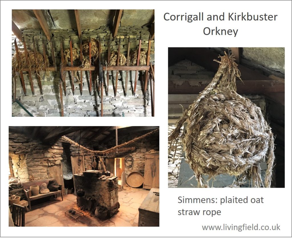
Fig. 3 Inside the Corrigall and Kirkbuster Museums on Orkney Mainland [5], showing plaited oat rope or simmens, balled for storage, and a rope hanging across the room over the fireplace (www.livingfield.co.uk).

Simmens is plaited from oat straw by hand, then typically stored as balls (Fig. 3). Its most celebrated usage was as a roofing material. It was looped from one of the eaves, over the top of the roof, down the other side, secured there and then looped back again, a procedure called needling.

The simmens rope was packed tightly to form a complete covering. In some places, straw was packed between successive layers of simmens and the roof completed with a final layer weighted down at the eaves by stones.

Where roof-stones were available, it was used as sarking, an inner layer, both as insulation and to secure thatch below the stone roof tiles. Vast quantities of oat straw – probably a few kilometers of it – were needed for a single house [4]. There must have been similarly vast quantities of long-stemmed oat grown to provide the straw.

The last few roofs that used it in Orkney were examined in the 1990s, but no attempt was made to conserve original simmens and it has all but disappeared. Could simmens be recreated today? One obstacle is ‘obtaining regular supplies of uncrushed, long-stemmed straw and the skill and amount of labour required to make and apply the simmens’ [4].

Simmens is on display at the Corrigall Farm Museum and the Kirkbuster Museum in Orkney [5]. Also demonstrated (on request) is a quick method of making temporary ‘rope’ or sookans from straw using a tool shown in Fig. 4. The tool is turned by one person, straw being fed through the hook, and the twisted straw pulled through by another.

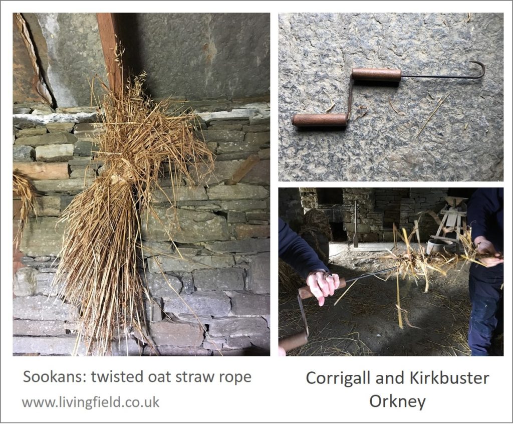
Fig. 4 Oat plants, probably bristle oat Avena strigosa, a tool used for twisting the oat straw into sookans and twisting in progress, Corrigall and Kirkbuster Museums Orkney (www.livingfield.co.uk).

Fibre unprocessed

These two plants, coconut and oat, are two of a number from which structural fibres can be extracted and used without the need for any highly technical processing (though coir extraction takes much effort and skill). They and others like them, including sisal and heather, would likely have been used from well before settled farming.

The two museums visited in 2019 are both excellent in their own way, each displaying ancient crafts and allowing people to see, and in Orkney touch, the exhibits. We have to admire how the peoples from mediaeval times back through Iron, Bronze and Stone ages built their ships, strong enough to cross some of the most dangerous seas around the Northern Isles.

Sources, links

[1] Asian Civilisations Museum is by the river in Singapore. Web site: https://www.acm.org.sg

[2] The Tang Shipwreck exhibition is on permanent display at ACM – superb layout and information. The museum offers a free guide book from which the information given here was taken, but much more detail can be found in a book sold there with the title The Tang Shipwreck and on Wikipedia at the Belitung Shipwreck (another name for it) which covers construction and contents and also the controversy surrounding excavation.

[3] Coconut fibre or coir is a protective coating between the inner ‘shell’ that shields the ‘flesh’ and milk and the outer tough skin. The fibre has become a substitute for peat in some horticultural uses, but its transport to Europe from the tropics is hardly sustainable as is sometimes claimed. The Wikipedia entry is useful: Coir. The Living Field relies for information on Burkhill’s massive treatise on the uses of plants (A Dictionary of the Economic Products of the Malay Peninsular, 1935, 1966) which describes the long process by which coir is extracted and made ready for use.

[4] Simmens (but also simmans and simmons in various modern sources) is made by plaiting oat straw. A photograph of simmens being used to thatch a roof is reproduced on the Living Field site at 5000/Fibres. The Scottish National Dictionary under Simmen gives examples of usage over the past few hundred years and indicates a Norse origin. Its use in roofing is described in the booklet:

Newman, P, Newman A. 1991. Simmens and strae: thatched roofs in Orkney. Extracted from ‘Vernacular building’ published by the Scottish Vernacular Buildings Group. Herald Printshop, Kirkwall.

[5] Orkney museums provide authoritative and very helpful and practical guidance to natural products and past farming. The main site is in Kirkwall – The Orkney Museum. The Corrigall Farm Museum at Harray and the Kirkbuster Museum Birsay are both in restored farm buildings.

Contact: geoff.squire@hutton.ac.uk or geoff.squire@outlook .com.

Ready steady mundify (your barley)

“There is made of barly a certaine kinde of drinke …. and a meate that is good for sicke persons, called mundified barly.” (L’Agriculture et Maison Rustique 1593)

More than Aquavitae

The Library of Innerpeffray [1] holds a book, named L’Agriculture et Maison Rustique (1593), that tells of, among other things, how to grow crops and use their products. Touch, open, read ….. and you will get to the page on mundified barly or barlie [2].

As in many sources from the 1500s through to the early 1900s, barley was viewed as a nutritious food – a health-giving corn, much more than a raw material for alcohol. The book gives instructions on preparing the barley and in one case adding fruit juices or seeds.

Boil it till it burst

Preparation begins with rough barley grain and converts it one way or another to the consistency of papmeate. One method is to boil it, beat it, strain it …. and then the surprise …. add to it various juices or seeds as available. Here’s the original, the spelling kept where possible [3]:

The almonds referred to were presumably still juiceful, well before maturity (unlike those top right in the photo below). Other sources [3] offer slightly different methods of preparation and and suggest adding grape juice. Probably the juice of any fruit or sweet vegetable leaf would do.

To wet it but not to make it swim

The second process seems more involved. Wet it but not so much that it swims, beat it, force off the husks, chafe it between the fingers, dry it in the sun, put it back in water, boil it to bursting, strain it. So stressful … ! Here is the original.

Much more than Aquavitae – but was it bere

So there is in this account – and there is in many accounts from barley-country everywhere – procedures and recipes to convert this life sustaining grain to a food or healthy drink!

In temperate climatic regions unsuitable for wheat, the meal or flour from barley and oats was the main source of carbohydrate. (The equivalent crops in tropical Africa, for example, are the sorghums and millets).

In Scotland, bannocks [5], a form of flatbread made from barley with oatmeal and sometimes peasemeal, sustained the populace before it came to rely on traded cereal products in the later 1900s. After being cooked, bannocks remained in shape, flat and round, and so could be carried about.

The book says little about the varieties of barley that were mundified. They could well have been similar to ones grown here – the landrace known as bere [6] and more modern (for that time) cultivated forms.

Varieties resembling Scottish bere were known from parts of Europe. Lawson and Son (1836, 1852) refer to a form of bere grown in France and Germany and also a bere-like, naked six-row barley said to have come from mainland Europe [6]. If they mundified in Scotland, they could have added local wild fruits in season (not melon or grapes) or even kale-juice.

Maybe the Living Field will try to mundify? More to follow on barley as a food and health drink …..

Sources

[1] The Library at Innerpeffray. On a visit to The Library in September 2019 (GS writes), I was handed a book L’agriculture et maison rustique.  The title page credits Charles Estienne and Jean Liebault. The book examined was dated 1593. Online sources list one edition printed in London 1600 with a variant of the title – The Countrie Farme – credited to Charles Stevens and John Liebault, and translated into English by Richard Surflet, Practitioner in Physicke. The book appeared in Latin, then in several languages and editions. Available online – see Dumbarton Oaks or search for the title.

[2] To Mundify: the Shorter Oxford Dictionary (third edition) indicates this is now rare or obsolete, descended from mundificare (latin) and meaning to cleanse, to purify, to free from noxious matter.

[3] The letter ‘u’ was written as ‘v’ and the letter ‘s’ has the appearance of a tall form of ‘f’. Barley appears as barlie and barly.

[4] Some examples. The title page of Dictionarire Oeconomique gives it written by M. Chomel in 1725: it advised the use of mundified barley or ‘barley water’ to counter various ailments (including Hectick-dever, for which the author also suggests small meals of frogs, snails, tortoise or good fish and ‘Asses Milk’). For another ailment, the preparation is a tisane of barley and marsh-mallow. In A garden of herbs by ES Rohde (1922), another 1600s source is given for a slightly different method of preparation, but the author calls it a Hordeat as well as mundified barley.

[5] The Living Field web site gives descriptions of bannocks made from assorted grain at Peasemeal, beremeal, oatmeal.

[6] Bere is a traditional barley landrace still grown in a few northern fields: further information at Bere line – rhymes with hairline. Lawson and Son’s descriptions of various beres can be found at Bere in Lawson’s Synopsis.

Contact/author: geoff.squire@hutton.ac.uk or geoff.squire@outlook.com

Online 16 October 2019, revised 6 November 2019.

Banana flowers, custard apples, fresh coconut and much more

One in a series on vegetable markets around the world: this one in ‘Little India’, Singapore.

Fresh vegetables, unpackaged, mean local production, short food chains, fine taste and a high nutritional content. The Living Field encourages local growing and use of vegetables, most recently through its Vegetable Map of Scotland.

But we also enjoy visiting fresh vegetable markets in other places, for example in Bangkok, Inle Lake Burma and Carsassonne in France.

Here we look at some of what’s on offer at Tekka, in the district of Singapore known as Little India [1]. As in most other vegetable markets, the goods offer a range of storage times from a few days to weeks or even months.

Here are some unusual ones … unusual to us that is. They are widely eaten throughout the tropics and sub-tropics. To the left of the three above are flowers of the banana or another plantain, encased in their reddish sheaths. The tough outer layers are usually discarded then the softer inners used in soups, salads and curries.

To the right are custard apples, not so appetising on the outside but split them with a knife to get at soft tasty fruits inside. In the middle, fresh coconuts, pared ready for extracting the ‘milk’, jostle on the central shelf, gourds above them and more banana products below. Just visible above the banana flowers (left) are two jackfruit, their rough surfaces protecting luscious, tasty, orange fruits inside.

Next are two types of fruit that will be more familiar in European supermarkets. Lower right in the panel above is a mass of gooseberries and above them the shiny purple fruits of brinjal (also known as aubergine and eggplant) of which there are many forms. The brinjal’s botanical name is Solanum melongena, relative of the potato therefore (Solanum tuberosum) and some poisonous nightshades. The wall poster to the left of them is advertising a vegetable mart.

And here are some more unusual ones. To the right of the flower stall (centre) are spiny gourds Momordica dioica, a fruit usually cooked as a vegetable, fried with meat for example. They are a little larger than a golf ball.

To the left are clusters of green ‘berries’ – the fruit of the pea eggplant or turkey berry Solanum torvum, used to give some bitterness to various dishes including curries.

So brinjal, pea aubergine and potato are part of the same plant group. People throughout the world have learnt to eat the safe parts of these Solanum species and leave or neutralise the inedible or poisonous parts (usually the leaves). Potato’s edible parts are tubers rather than fruits – though if left to flower and fruit, potato produces berries similar in appearance to those of pea aubergine [3].

And finally there are things both familiar and exotic. To the left are limes and next to them sections of banana stem. Then in the panel of three to the right are what looks like a type of okra or cucumber, green but characteristically streaked with white, then tomato in the centre and at the bottom a collection of carrots, beans and what are probably long tubers locally called ‘radishes’ but which are not a bit like the small oval radish grown in Britain.

Further sources and links

[1] Little India, Singapore: vegetables, herbs and spices at and around the Tekka Centre off Serangoon Road and Bukit Timah Road.

[2] Information on the trees and shrubs mentioned above can be found in several searchable databases: e.g., see entries for custard apple Annona reticulata at the Agroforestree database of the World Agroforestry Centre and the CABI Invasive Species Compendium.

[3] Potato plants can form fruits in fields in Scotland and if dropped, persist in the soil for many years, giving rise to ‘volunteer’ populations that occur as weeds in subsequent crops of potato or other species. The role of potato as a weed is described on this web site at Crop-weeds.

All images by Living Field.

The Library of Innerpeffray

On a bank high above a branch of the Earn and overlooking agricultural grazing land sits The Library of Innerpeffray. It is a Library of old books, open to the public and with a remarkable ethos of access before conservation. You have to travel along twisting roads, between Perth and Crieff, to get there …. but what a place!

The founding of the Library in the late 1600s by a local landowner is described at the Library’s web site [1]. The people – not just the gentry – could read and borrow books. That tradition continues.

Andrew Wight’s travels published 1778-1784

The Living Field has often referred to The Current State of Agriculture in Scotland – anonymous but written by Wight – as a source of knowledgeable and first hand appraisal of the agricultural Improvements instigated by certain farmers and landowners [2]. And here it is on the shelves to be opened, the pages turned. Some sentences from the Preface, not by Wight, justify his years-long mission .

Improvements to land use and production had been made by some but not widely taken up. So in an age of slow communication between widely separated and sometimes isolated farming regions, there needed to be a means to share knowledge and good practice.

Quite possibly, the sentiments written above could apply to any age!

Mundified barlie, oates and Durer’s rhinoceros

L’Agriculture et Maison Rustique was published first in Italian, then in French and English [3]. The Library had copies of the latter two, the front page of the one examined dated 1593. It’s an early account of crops and their uses. On pages devoted to cereals, it explains how to mundify barley, to convert it to the consistency of papmeate and to add fruits and seeds for taste as available or desired [4].

Then on oats, the book refers to the property of oat seed to emerge in other crops (known today as ‘volunteer’ weeds).

But which oats were they – possibly a more primitive variety such as black oat Avena strigosa, known by some in Britain as ‘famine food’? The writers then refer to the use of oatmeal boiled and enriched with meat into a porridge-like consistency.

There is no end to the interest and fascination. The celebrated wood engravings of the rhinoceros by the artist Albrecht Durer [5] were there for visitors to see, unphotoshopped, the ink lettering coming through from the back of the page.

Sources

[1] The Library of Innerpeffray, by Crieff, Perthshire, Scotland. Web: The Library of Innerpeffray.

[2] Andrew Wight’s journals referenced by the Living Field: Great quantities of aquavitae, Great quantities of aquavitae II, The Mill at Atholl; and various articles in the Bere line – rhymes with hairline.

[3] L’Agriculture et Maison Rustique by C Estienne and J Liebault, various editions from the 1500s and 1600s in French and English available online, e.g. see Dumbarton Oaks or search the Biodiversity Heritage Library.

[4] Ready steady mundify – a short note on mundified barley this web site).

[5] Albrecht Durer (1471-1578), a German Renaissance artist, engraved an image of an Indian rhinoceros, which he had not seen directly but crafted from verbal descriptions and a drawing. There are several versions, the one above photographed from an book of unusual animals at The Library of Innerpeffray.

Moon rills and Apollo 15

The present ‘image of the month’ shown at the top of the right-hand margin is one of Ken Kennedy’s photographs of the moon’s surface. Ken and colleagues from Dundee Astronomical Society [1] have worked with the Living Field for years, exhibiting at our open days and writing about the sun, moon and atmosphere [2].

Here’s the photograph:

The moon surface showing the Hyginus Rille – a thin line stretching (just below centre) diagonally down to the right – and the complex of rills around the Triesnecker crater, 11 May 2019 (Ken Kennedy)

“The image you have chosen shows the dogleg of the Hyginus Rille, a volcanic feature along which you will see a series of small craterlets.  Above the Hyginus Rille and to right centre you will see a distinct but fairly small crater called Triesnecker.  When I took the image I was attempting to catch the complex of rilles around this crater and, on this occasion, I was successful.”

“These rilles are believed to be of ‘tectonic’ origin which probably means that they are ‘cracks’ in the Moon’s surface due to early shrinkage and moonquakes.  Other rilles are caused by lava flow or graben faults causing collapse of a section of ground.”

Apollo moon missions

“The memory seeing Apollo 11 live on television 50 years ago is still vivid in my mind. Although I did not meet Armstrong or Aldrin I did meet David Scott, commander of Apollo 15 when he visited Mills Observatory in 2005.  I was astronomer there at the time and was able to ask the seventh man to walk on the Moon about Hadley Rille near to where Apollo 15 landed. “

“David Scott and James Irwin took the lunar rover to the edge of Hadley Rille and he told me that, contrary to it’s telescopic appearance, the walls of the rille are at an angle of about 45 degrees.  He said that he could have walked into the rille – but did not do so! 

 He was kind enough to sign a photograph of himself on the Moon beside Hadley Rille.  I have also attached an image I took in May which shows the Apollo 15 landing site.”

With thanks to Ken for the moon images and the historical connection.

Sources, links

[1] Dundee Astronomical Society has a very active membership and an extensive web site: dundeeastro.

[2] More on the Society can be found on this Living Field page livingfield/people/dundeeastro.

[2] Jim, Ken, June Andy and Tony from DAS demonstrated telescopes and astronomical images at Open Farm Sunday on 9 June 2019 – “one of the busiest we ever attended”. On the day, Geoff Squire and Glady Wright from the Living Field project were presented with certificates as Honorary Members of DAS. With thanks!

Diverse ‘grass’ mixtures in the living field meadow

Mixtures sown for hay or grazing in the 1800s. Grass, legumes and other broadleaf plants selected for their ablity to live together. Many of the plants grown then coexisting now in the Living Field garden. Lessons for grass rediversification today. One of a series of articles on crop-grass diversification.

The run of bad weather, crop failure and hunger of the late 1600s, sometimes called ‘the ill years’, was one of the factors that led to a period of agricultural improvement from the early 1700s to the late 1800s. The improvements raised and to a degree stabilised food production. One of the most important developments was the design and trialling of species-rich plant mixtures for hay and grazing.

Early accounts of ‘grass’ mixtures by agriculturalists, notably Stephens, Elliot and Findlay, are valuable to us today because they gave weights of the seed of each plant species that made up the mix [1]. Though weight of sown seed does not translate directly into mass of the species in the field, it is the only measure handed down to us by which the diversity of those old mixes can be quantified and compared with today’s commercial seed mixtures.

Why is this important? Over the last 150 years, crop-grass agriculture has become less diverse, more dominated by a few grass species and in the process losing many ecological functions. Plans to re-diversify could learn from past practice.

Mixing grass, legume and other broadleaf species

The hay and grazing mixtures from this period are summarised in a related web article [1] as circular diagrams, the inner ring showing the proportions of grass (blue-green), nitrogen-fixing legume (red) and, when included, other broadleaf plants (orange-brown), while the outer ring shows the proportions of individual species. The diagrams below show the rise in complexity of the mixtures from one-year-hay (1) to two-year grazing (2) and permanent pasture (3, 4).

Examples of hay and grazing mixtures of increasing complexity 1 to 4, main groups in the inner ring, species in the outer, based on weight of seed [1].

The main feature of those mixes – though rarely seen today in commercial grass fields – is the presence of several legumes species and sometimes broadleaf plants other than legumes. The role of the legumes is to fix nitrogen gas from the air and so enrich the soil for the grass species at a time when mineral fertiliser was not widely available. The other broadleaf species were included to fill ecological gaps (functions and processes) that could not be provided by the grasses or legumes.

Meadow plants in the Garden

The meadow in the Living Field garden [2] was sown back in 2004. In the first few years, the most visible plants were those that grew quickly and flowered in the first or second year. These annuals and biennials were soon ousted by perennials, some that had been sown and others that came in. After 5 or 6 years the meadow was populated by a diverse group of perennials.

The meadow has been lightly managed – cut once a year, usually in September. Yet many of the plant species that were part of the 1800s mixtures appear naturally able to coexist in the meadow and surrounding patches.

The legumes

The typical legumes in early grass mixtures were clovers, the red and white species but also alsike and several others. Red Trifolium pratense was thought best for one year’s hay because it was fast growing but short lived, while white Trifolium repens persisted much longer and was suited to pasture. Both have lived in the meadow for at least a decade. Alsike Trifolium hybridum was grown as part of a legume collection a few years ago but has not remained.

Other legumes in sown mixtures from the 1800s included the bird’s-foot trefoils, mainly Lotus corniculatus which is as common in the meadow as white clover, and kidney vetch Anthyllis vulneraria which persists as only a few plants here and there among the grasses and sometimes in the medicinals bed.

The meadow has other legume species, of the genus Vicia, that were not generally favoured in earlier mixtures because they have tendrils and so tend to twine among and drag down the grasses and other plants.

Two common tendril-bearing species recur in the meadow each year – common vetch Vicia sativa which generally keeps to itself and hairy tare Vicia hirsuta which can become a serious weed (as this year) smothering other plants. A third one of this type, tufted vetch Vicia cracca tends to move around unkempt patches rather than live in the meadow.

The images in the legume panel above show (top left, clockwise) white clover among grass and plantain, common vetch, kidney vetch and red clover with bird’s-foot trefoil (yellow flowers).

The other broadleaf plants

It may come as a surprise today to learn that plants other than grasses and legumes were purposely sown in fields as part of mixtures for hay and pasture. Of those reported from the 1700s and 1800s, the commonest in the meadow itself are yarrow Achillea millefolium and ribwort plantain Plantago lanceolata.

Two others have appeared in grassy areas – chicory and burnet. Chicory Cichorium intybus was first planted in the medicinals bed, but has spread and now lives among grasses such as yorkshire fog and cocksfoot. Its main role in the 1800s mixtures was to break through soil pans that formed at 10-20 cm depth due to the shallow ploughing that was typical of the time.

A few plants of burnet Sanguisorba minor were noted a some years ago, and like chichory have persisted for years among competitive grass species. We do not know where the burnet came from.

The images above show (top left, c’wise) burnet and ribwort plantain among grasses, yarrow leaf, chicory plant with blue flower inset, burnet leaves and red stems. and finally ribwort plantain with flower inset.

The grasses

They might ‘all look the same’ in leaf, but their basic floral structure recurs in many forms to give great diversity among our common grass species. Many of the early sown mixtures included timothy-grass Phleum pratense, cocksfoot Dactylis glomerata, crested dog’s-tail Cynosurus cristatus, several fescues (Festuca species) and tall meadow-grasses (Poa species), all of which are present in the meadow.

Two other pasture grasses are common in the garden – sweet vernal-grass Anthoxanthum odoratum and yorkshire fog Holcus lanatus which become established wherever the ground is left untilled for a few years.

The grass panel above shows (top left, c’wise) mainly yorkshire fog growing among wild carrot, flowering heads of sweet vernal and timothy and (from the early years) fescue and crested dog’s-tail among ox-eye daisy.

High diversity – low management

The 1800s mixtures were designed to give a balanced diet for livestock and to ensure fresh plant tissue was present for a long as possible during the year. They mixed species to ensure that each came to prime leaf or seed at different times. For hay, the progression of floral or reproductive structures was important, for pasture the blend of leafy parts.

The meadow in the Living Field garden also harbours other plants sown specifically for wildlife, including field scabious, perhaps the favourite of the pollinating insects, ox-eye daisy and lady’s bedstraw. At one time wild carrot lived in the meadow (top left in the grass panel above) but now prefers grassy margins next to paths. Even with these additional species, the meadow complex retains many of the species sown for hay and pasture from the 1700s to the early 1900s.

The secret of sustaining the meadow is to keep soil fertility low by not fertilising and ground cover high by growing many species that quickly react to fill any gaps. No one species dominates and noxious weeds are given little chance to enter.

Sources

[1] The original sources, mainly Wight (late 1700s), Stephens (1841 onwards), Elliot (1898 onwards) and Findlay (1925) are given in this companion article: Grass mix diversity a century past on the curvedflatlands web site.

[2] The origin, main species and management of the meadow are described on this web site at Garden/Meadow and Garden/The_making. The drone image below from early 2019 shows the location of the meadow (covering about 200 square metres), see also : Living Field garden from the air.


The Living Field team has maintained very high diversity per unit area here for almost 15 years.

Contacts: this article geoff.squire@hutton.ac.uk; meadow management gladys.wright@hutton.ac.uk.

Veg posters from open farm sunday

What a great day, 9 June! Yet another successful Open Farm Sunday at the Hutton Dundee. Crowds of visitors enjoying themselves in sunny weather. The Living Field garden did its bit as before – exhibits on barley and legumes in the polytunnel, potato varieties in the west garden and further science exhibits in the cabins.

Our friends from Dundee Astronomical Society were here again showing people round the new observatory and explaining about the sun, moon and noctilucent clouds. And this year we were helped for the first time by a workshop on cyanotype imagery run by Kit Martin.

The centrepiece was the new Vegetable Map of Scotland, shown top left and centre in the panel above. For more on how it was made, see Vegetable map made real. The map occasioned much comment and wonder that the country was already growing such a wide range of vegetables and could grow much more of its own.

The two posters located next to the Vegetable map are available to view or download here.

The Vegetable Posters

One of the posters – The Vegetable Products of Scotland – explained the background to the original Vegetable map which was first shown at Can we grow more vegetables? The poster is reproduced below as a low resolution jpg image. It is also available as a pdf file printable up to A3 size.

Click for an A3 size pdf of the Vegetable Products of Scotland.

The other poster – Vegetables in the Living Field garden – showed many of the vegetables typically grown in the garden, grouped into leaves, fleshy fruits, roots and seeds. More on the plants can be seen at the garden pages under Vegetables. This poster is also reproduced as a jpeg below and available as a pdf.

Click for an A3 size pdf of Vegetables in the Living Field garden.

Contacts for Living Field activities: gladys.wright@hutton.ac.uk or geoff.squire@hutton.ac.uk

Open Farm Sunday was a joint effort between The Farm, science staff, the events team, the Living Field community and many others.

Living Field garden from the air

June 2019 and the various projects based in and around the Living Field are starting to bear. The Farm flew its drone on 5 June to get a photograph of the Vegetable Map of Scotland and at the same time took in the whole of the garden.

The garden was designed so that some parts would remain fixed – the habitats – and other parts would change as new ideas and projects replaced older ones. The fixed parts in the image below are mostly in the right hand (east) section – the meadow, the trees, the hedges and the small pond and ditch, which is just not visible behind the lower hedge.


The plots to the north east just inside the hedges have held a small collection of medicinal and dye plants for several years and so are also almost fixed.

The Vegetable Map in the lower right quadrant is placed on the site of the previous arable plot which has grown cereals, roots, vegetables and various legumes for well over ten years, but we decided this year to turn it into something different. The image of the map below has been turned round, with north to the right.

The intention is to keep the shape of the map over time but change the cultivated plants that are being inserted into the fertile regions of the country. This year peas, potato and assorted vegetables will be grown.

The west garden is split into four plots. The top left one (north west) holds a polytunnel, used for activities when it is raining.

The top right is a exhibition area in which raised beds have been built. A few years ago they were used to contain the forage legume collection (e.g. lucerne, milk vetch, tufted vetch, kidney vetch). After that we had a varied display of vegetables and herbs and now in 2019 they are mainly occupied by the Barley Timeline, an assortment of barley landraces and varieties grown since the 1800s. There are still some herbs retained in the centre bed.


The third quadrant, south east, is down to mown grass, a space for various activities. It becomes a picnic area on open days. It also houses Dundee Astronomical Society’s observatory.

The fourth, in the south west, has had a range of plants grown in it, recently annual mixed ‘grass’ consisting of both traditional grass and broadleaf plants, and now this year a collection of potato varieties, many developed at the Institute.

The Living Field community

While the overall garden and its activities are managed by a small group, a wide range of people have been involved since first the ground was drained and levelled in 2004 – see The Making.

The Farm staff do all the hedge cutting and soil cultivation and this year the carting of rocks and laying of turf for the Vegetable Map. The Workshop make the signs, prepare the corn grinder and do whatever needs fixing. Horticulture and glasshouse colleagues help to pot and raise the thousands of plants that go out each year. Science staff, mainly from Ecological Sciences, provide the knowledge of plants, their functions and how to grow them.

What may be surprising is that very little (if any) of the contributions are formally costed. There are no project specs to adhere to. Quite a bit of the effort is given voluntarily, out of hours. This genuine community is what makes the Living Field work.

Vegetable map made real

Since its publication on these pages in 2017 the Vegetable Map of Scotland [1] has attracted much interest. There is a growing awareness of the benefits of local, nutritious food – especially if bought from short supply chains that use the least possible carbon.

People want to know where their food comes from, how much is imported and how much grown locally and whether the country can grow more of its food within or near its borders.

These questions are asked especially of vegetables, including pulses and potato, because they are (or should be) mostly eaten very fresh, such as leaf, or else, like carrot and swede, kept not too long on the shelf before being cooked.

With this background of interest, the Vegetable Map was constructed by researchers at the Institute as part of joint interests with Nourish Scotland [2]. The group interrogated EU databases provided by the Scottish Government [3] to locate the fields in which the various vegetables and soft fruits were grown.

Part of the Vegetable Map showing Strathmore, Angus and Fife

An example of part of the region is shown above. The Map remained available through this web site, then in late 2018, ideas began to form about making the map real – complete with vegetables – and it would be constructed in the Living Field garden [4].

Tayside’s neolithic?

Time went by. Ground was weeded, cleared and cultivated – a rare barrenness in the otherwise plant-rich garden. Then gradually, over the winter, tectonic plates shifted.

People began to wonder about the strange earthworks dotted with rocks that appeared in the plot. Was the garden being visited at night by strange forces or was the Living Field community finally just losing it? Rumours were rife.

Rocks laid in formation and the ground smoothed again

More time went by. Turf was laid in a great rectangle over the whole patch, but people were still unclear of what it was all for …. and what lay underneath.

The turf rooted and formed a fine carpet. But what were the rocks? A ritual landscape? Tayside’s answer to the Ring of Brodgar?

The laying of the turf, before the winter 2018/19

Then one day in late spring 2019 an outline was traced and the turf was cut to reveal the unmistakable shape of ….. Scotland ….. its indented coast now clear and the land inside complete with hills and mountains.

All well so far ……. a map of the country covered in grass and rocks …… nothing new there. But then in May, holes were cut in the turf and plants put in the holes: and you’ll guess what plants – Yes, vegetables.

The map complete, ready for the vegetables in spring 2019

And that is where we are at the beginning of June 2019. The Farm’s drone was flown to photograph the Living Field garden from the air on 5 June. The image of the map appears below.

Different types of vegetable are being planted in the parts of the country where they are typically grown. It is possible to see the early plantings to the right of the image. The brown holes in the turf are where circles have been cut in readiness for later plantings. (The ‘corners’ and lower border are spare turf in case of need.)

The Vegetable Map in the Living Field garden, taken by The Farm’s drone on 5 June 2019

Planting will continue well into the summer. There will be some surprises which we shall show later.

For now, you can read more about the history of vegetable growing at the original page [1]. photographs of the construction will follow – link to be provided. And there will be more articles on what can and can’t be grown in the soils and climates of our northern latitudes.

Living Field people will be on hand at Open Farm Sunday 9 June 2019 to explain more about the Vegetable Map of Scotland. See you there!

With apologies to the Outer Hebrides, Orkney and Shetland, presently missing from the map but to be included.

Sources, references, links

[1] The Vegetable Map of Scotland at Can we grow more vegetables? was constructed by Nora Quesada with Graham Begg and Geoff Squire.

[2] Nourish Scotland at nourishscotland.org and Peas please.

[3] The original digital map was produced during work on the distribution of crops as part of the Scottish Government’s Strategic Research Programme.

[4] Gladys Wright had the idea of constructing the Vegetable Map in the Living Field garden and was soon offered enthusiastic help by The Farm. Together, and with other coopted helpers they measured out the grid, made the mountains (like Titans), laid and cut the turf and raised and planted the plants. A great effort by the Living Field community!

[5] Further links to the map on this site: Living Field garden from the air and Veg posters from Open Farm Sunday.

Contact: gladys.wright@hutton.ac.uk, geoff.squire@hutton.ac.uk

Resilience to the 2018 drought

The 2018 summer of low rainfall was one of the driest on record. Cereal grain harvest dipped but did not fail, loss of production caused more by conditions in the previous winter than the summer drought. A further example of grain harvest’s resilience to untypical weather in the north-east Atlantic. 

The long summer of unusually low rainfall in 2018 parched much of the grassland and stunted many of the cereal crops. The wheat and barley appeared to suffer in many places. A record low for grain output looked set to happen. Yet the yield figures suggest a remarkable resilience to what turned out to be unusual weather for the region. 

First the rainfall …. How low was it? 

Daily rainfall records for East Scotland

The Met Office provides a valuable series of historical rainfall data. The analysis here uses the daily series for regions of the UK from 1931 [1]. The Met region ‘East Scotland’ is the one where most of the wheat, barley and oats are grown.  The period in 2018 from April to the end of August joins that of several other years in being unusually dry – 1955, 1976, 1981, 1984, 1995, and 2003 all had rainfall below 200 mm (Fig. 1). 

Fig. 1 Total rainfall between 1 April and 31 August for the East Scotland region in all years since 1931. The line just below 200 mm is the value in 2018. Years of low summer rainfall are arrowed. Data source: Alexander & Jones, 2001 [1].

There is little sign of any major trend in either low or high rainfall over the main summer period. Many of the other years after 2000 were much wetter than 2003 and 2018. The highest point in recent times was the very wet 2012, which had more rainfall than all other years except two. What distinguishes 2018 is the pattern of rainfall.

Many of the years having low summer rainfall had a fairly wet May, as evident in the steep rise in cumulative rainfall in 1976 and 2003 in Fig. 2. The same sort of thing happened in 1955 (not shown). This rainfall in May probably fills the soil enough to allow the crops to last through a dry June and July at which point most of the season’s growth has occurred.

Fig. 2 Cumulative summer rainfall, East Scotland from April for four dry years including 2018 (symbols). Data source: Alexander & Jones, 2001 [1].

2018 had a wetter April then most other dry years but then low rainfall until late July. Although 1984 had the lowest rainfall overall, 2018 had the lowest from late April through to mid-July, which is when the solar income is large and when the crops are bulking. Summer rainfall in 2018 would have been less than in 2003 if it had not been for that rain in late July and early August.

So did this low rainfall during crop bulking have an effect?

Yield figures for 2018

Each year the Scottish Government provide absolute records of crop-areas (i.e. all fields counted) and estimates of yield per unit area based on data from a range of sources. The final estimates are published in December [2].

The wet year of 2012 provides a comparator: most crops but particularly wheat, oats and oilseed rape produced a low yield per unit area that year because of waterlogged soil and low solar income [3]. Total cereal output was lower than in any other year of the past two decades. 

The records show 2018 yields were no worse. Wheat yield per unit area (t/ha) was down to near the 2012 value but most of the other crops showed little fall in yield (Fig. 3). When expressed as a percentage of the average of recent years, the simultaneous dip among crops in 2012 was not repeated in 2018 (Fig. 4). 

Fig. 3 Grain yield of wheat (red), oats (black) and oilseed rape (blue) over the last 20 years.

Was anything different about 2018. Total cereal output (the sum of wheat, barley and oats) was low, in fact just above the 2012 value, but this was due to reduced land areas sown with cereals, mainly winter barley which was sown in the autumn of 2017 before the summer drought of 2018. Sources in [2] state ‘Winter barley area dropped by a fifth due to poor weather conditions. This, along with a four per cent drop in yield resulted in production decreasing by 24 per cent.’ The greater effect therefore occurred before the winter and ‘was a result of the difficult weather conditions in late 2017.’

Fig. 4 Grain yields in Fig. 3 as a percentage of the average over the period, wheat (red), oats (black), oilseed rape (blue).

It appears therefore that yields per unit area – the best guide to the effect of weather on the summer bulking conditions – were not strongly affected by the 2018 drought.  

Caution is needed because the yield figures are an estimate, i.e. not measured for all crops. Some crops were not harvested for grain at all, where the weather ‘resulted in a number of farmers choosing to whole-crop due to the low yield and quality [2].’ (Whole-crop means to take all the crop for feed without separating the grain.) Some of the poorest yielding fields might have been removed from the estimate of yield therefore. 

Could grain yields collapse in this region?

Drought leads to zero crop yield in many countries. Even in parts of Australia, where standards of agronomy and resource-use are high, recent droughts have led to total failure of cereal crops that are not irrigated. 

So could crop failure occur here? In principle yes. But it would have to be a much drier year than any since the records began in 1931. Given there is no discernible trend towards low summer rainfall and that most years between 2003 and 2018 were wet, and two of those years – 2014 and 2016 – produced among  the highest mean yields ever in this region, there are certainly no indications that summer droughts will become a feature of the Atlantic maritime cropland.

Then again, you can’t trust the weather …. [4].

Sources, links

[1] Daily rainfall series from 1931: Alexander, L.V. and Jones, P.D. (2001) Updated precipitation series for the U.K. and discussion of recent extremes, Atmospheric Science Letters doi:10.1006/asle.2001.0025. Further information at the Met Office’s Hadley Centre web site: https://www.metoffice.gov.uk/hadobs/hadukp/

[2] Cereal and oilseed rape harvest: 2018 final estimates:  https://www.gov.scot/publications/cereal-oilseed-rape-harvest-2018-final-estimates/ Published 12 December 2018. See also https://blogs.gov.scot/statistics/2018/10/04/2018-scottish-cereal-harvest/ 

[3] Links to Living Field articles on high rainfall: The late autumn floods of 2012, Winter flood,  Winter flood … continued and Effects on corn yields of the 2016 winter flood.

[4] A fuller version of this article will appear on the curvedflatlands web site: link to be available later.

Author/contact: geoff.squire@hutton.ac.uk or geoff.squire@outlook.com