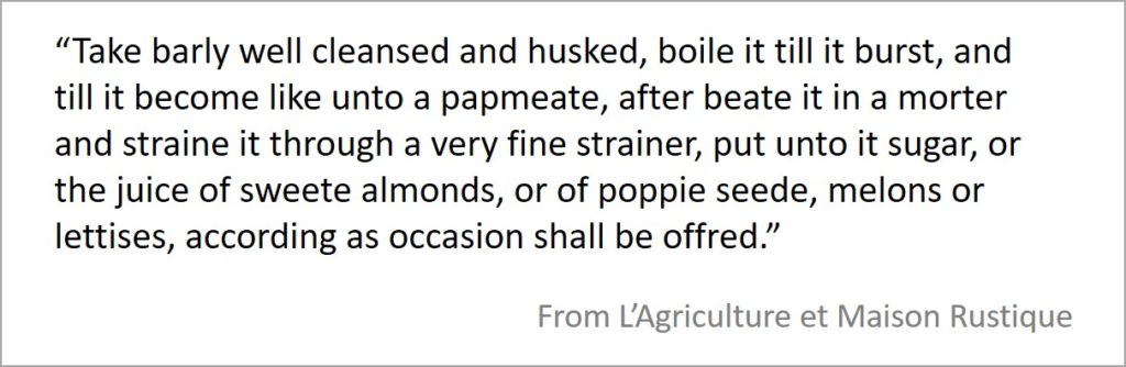
“There is made of barly a certaine kinde of drinke …. and a meate that is good for sicke persons, called mundified barly.” (L’Agriculture et Maison Rustique 1593)
More than Aquavitae
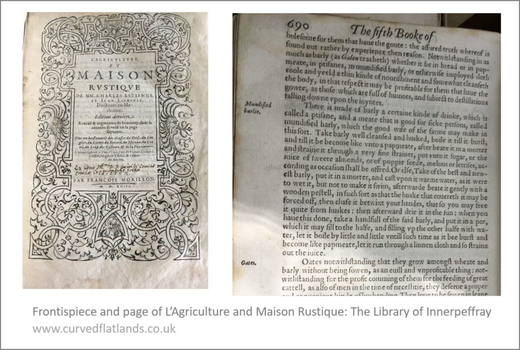
The Library of Innerpeffray [1] holds a book, named L’Agriculture et Maison Rustique (1593), that tells of, among other things, how to grow crops and use their products. Touch, open, read ….. and you will get to the page on mundified barly or barlie [2].
As in many sources from the 1500s through to the early 1900s, barley was viewed as a nutritious food – a health-giving corn, much more than a raw material for alcohol. The book gives instructions on preparing the barley and in one case adding fruit juices or seeds.
Boil it till it burst
Preparation begins with rough barley grain and converts it one way or another to the consistency of papmeate. One method is to boil it, beat it, strain it …. and then the surprise …. add to it various juices or seeds as available. Here’s the original, the spelling kept where possible [3]:
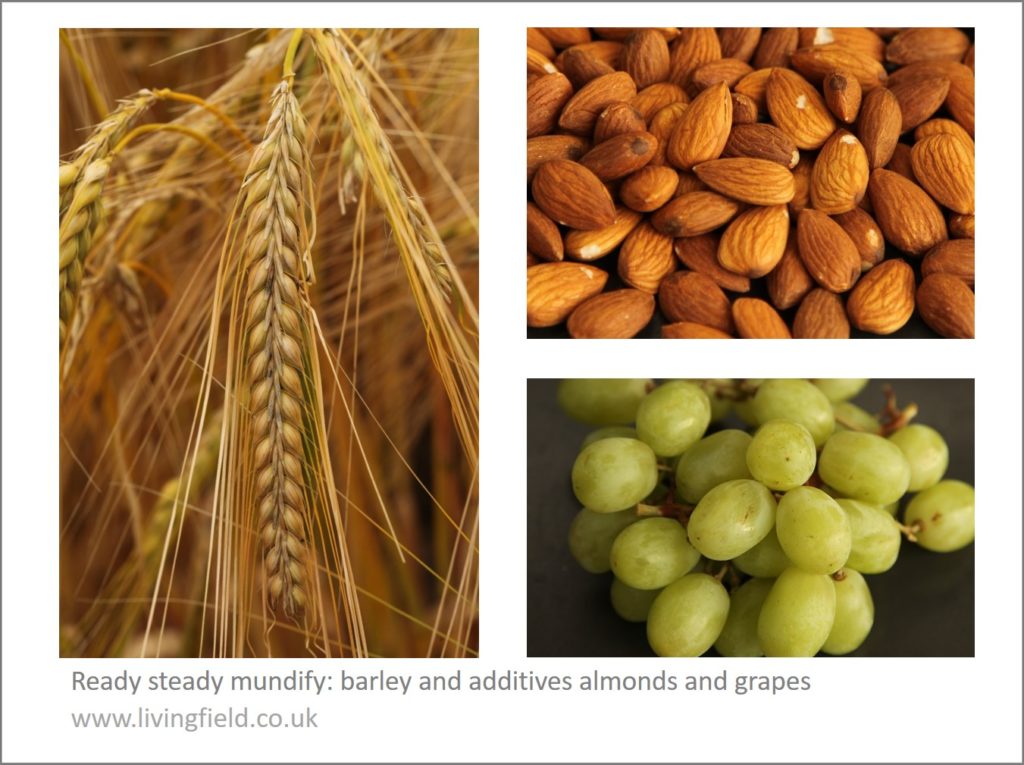
The almonds referred to were presumably still juiceful, well before maturity (unlike those top right in the photo below). Other sources [3] offer slightly different methods of preparation and and suggest adding grape juice. Probably the juice of any fruit or sweet vegetable leaf would do.
To wet it but not to make it swim
The second process seems more involved. Wet it but not so much that it swims, beat it, force off the husks, chafe it between the fingers, dry it in the sun, put it back in water, boil it to bursting, strain it. So stressful … ! Here is the original.
Much more than Aquavitae – but was it bere
So there is in this account – and there is in many accounts from barley-country everywhere – procedures and recipes to convert this life sustaining grain to a food or healthy drink!
In temperate climatic regions unsuitable for wheat, the meal or flour from barley and oats was the main source of carbohydrate. (The equivalent crops in tropical Africa, for example, are the sorghums and millets).
In Scotland, bannocks [5], a form of flatbread made from barley with oatmeal and sometimes peasemeal, sustained the populace before it came to rely on traded cereal products in the later 1900s. After being cooked, bannocks remained in shape, flat and round, and so could be carried about.
The book says little about the varieties of barley that were mundified. They could well have been similar to ones grown here – the landrace known as bere [6] and more modern (for that time) cultivated forms.
Varieties resembling Scottish bere were known from parts of Europe. Lawson and Son (1836, 1852) refer to a form of bere grown in France and Germany and also a bere-like, naked six-row barley said to have come from mainland Europe [6]. If they mundified in Scotland, they could have added local wild fruits in season (not melon or grapes) or even kale-juice.
Maybe the Living Field will try to mundify? More to follow on barley as a food and health drink …..
Sources
[1] The Library at Innerpeffray. On a visit to The Library in September 2019 (GS writes), I was handed a book L’agriculture et maison rustique. The title page credits Charles Estienne and Jean Liebault. The book examined was dated 1593. Online sources list one edition printed in London 1600 with a variant of the title – The Countrie Farme – credited to Charles Stevens and John Liebault, and translated into English by Richard Surflet, Practitioner in Physicke. The book appeared in Latin, then in several languages and editions. Available online – see Dumbarton Oaks or search for the title.
[2] To Mundify: the Shorter Oxford Dictionary (third edition) indicates this is now rare or obsolete, descended from mundificare (latin) and meaning to cleanse, to purify, to free from noxious matter.
[3] The letter ‘u’ was written as ‘v’ and the letter ‘s’ has the appearance of a tall form of ‘f’. Barley appears as barlie and barly.
[4] Some examples. The title page of Dictionarire Oeconomique gives it written by M. Chomel in 1725: it advised the use of mundified barley or ‘barley water’ to counter various ailments (including Hectick-dever, for which the author also suggests small meals of frogs, snails, tortoise or good fish and ‘Asses Milk’). For another ailment, the preparation is a tisane of barley and marsh-mallow. In A garden of herbs by ES Rohde (1922), another 1600s source is given for a slightly different method of preparation, but the author calls it a Hordeat as well as mundified barley.
[5] The Living Field web site gives descriptions of bannocks made from assorted grain at Peasemeal, beremeal, oatmeal.
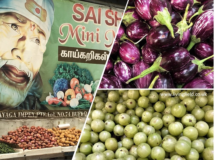
One in a series on vegetable markets around the world: this one in ‘Little India’, Singapore.
Fresh vegetables, unpackaged, mean local production, short food chains, fine taste and a high nutritional content. The Living Field encourages local growing and use of vegetables, most recently through its Vegetable Map of Scotland.
But we also enjoy visiting fresh vegetable markets in other places, for example in Bangkok, Inle Lake Burma and Carsassonne in France.
Here we look at some of what’s on offer at Tekka, in the district of Singapore known as Little India [1]. As in most other vegetable markets, the goods offer a range of storage times from a few days to weeks or even months.
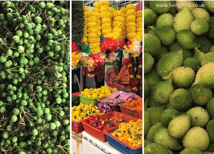
Here are some unusual ones … unusual to us that is. They are widely eaten throughout the tropics and sub-tropics. To the left of the three above are flowers of the banana or another plantain, encased in their reddish sheaths. The tough outer layers are usually discarded then the softer inners used in soups, salads and curries.
To the right are custard apples, not so appetising on the outside but split them with a knife to get at soft tasty fruits inside. In the middle, fresh coconuts, pared ready for extracting the ‘milk’, jostle on the central shelf, gourds above them and more banana products below. Just visible above the banana flowers (left) are two jackfruit, their rough surfaces protecting luscious, tasty, orange fruits inside.
Next are two types of fruit that will be more familiar in European supermarkets. Lower right in the panel above is a mass of gooseberries and above them the shiny purple fruits of brinjal (also known as aubergine and eggplant) of which there are many forms. The brinjal’s botanical name is Solanum melongena, relative of the potato therefore (Solanum tuberosum) and some poisonous nightshades. The wall poster to the left of them is advertising a vegetable mart.
And here are some more unusual ones. To the right of the flower stall (centre) are spiny gourds Momordica dioica, a fruit usually cooked as a vegetable, fried with meat for example. They are a little larger than a golf ball.
To the left are clusters of green ‘berries’ – the fruit of the pea eggplant or turkey berry Solanum torvum, used to give some bitterness to various dishes including curries.
So brinjal, pea aubergine and potato are part of the same plant group. People throughout the world have learnt to eat the safe parts of these Solanum species and leave or neutralise the inedible or poisonous parts (usually the leaves). Potato’s edible parts are tubers rather than fruits – though if left to flower and fruit, potato produces berries similar in appearance to those of pea aubergine [3].
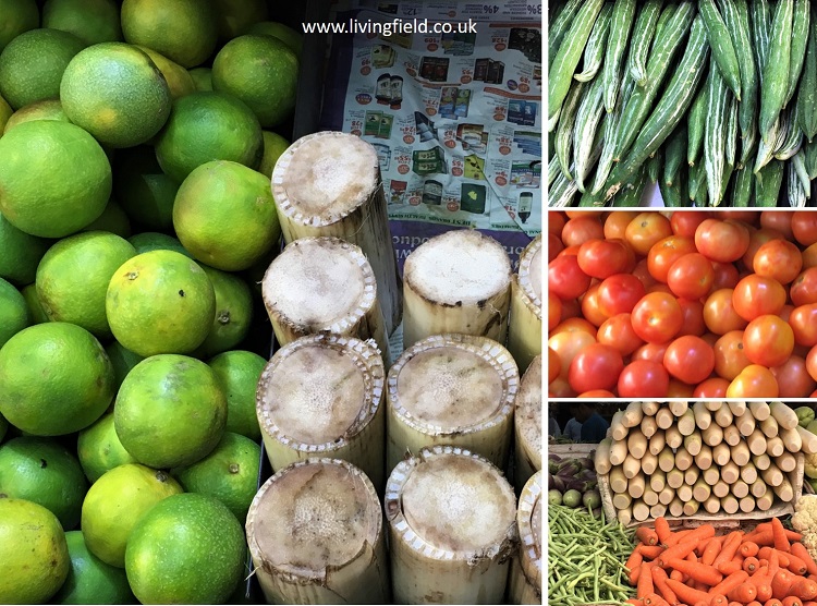
And finally there are things both familiar and exotic. To the left are limes and next to them sections of banana stem. Then in the panel of three to the right are what looks like a type of okra or cucumber, green but characteristically streaked with white, then tomato in the centre and at the bottom a collection of carrots, beans and what are probably long tubers locally called ‘radishes’ but which are not a bit like the small oval radish grown in Britain.
Further sources and links
[1] Little India, Singapore: vegetables, herbs and spices at and around the Tekka Centre off Serangoon Road and Bukit Timah Road.
[2] Information on the trees and shrubs mentioned above can be found in several searchable databases: e.g., see entries for custard apple Annona reticulata at the Agroforestree database of the World Agroforestry Centre and the CABI Invasive Species Compendium.
[3] Potato plants can form fruits in fields in Scotland and if dropped, persist in the soil for many years, giving rise to ‘volunteer’ populations that occur as weeds in subsequent crops of potato or other species. The role of potato as a weed is described on this web site at Crop-weeds.
Vegetables and fruit in Scotland mapped. Regions of historically strategic land and soil. The Iron Age, then the Romans, Picts and 1700s Improvers. Imports vs local production. Opportunities.
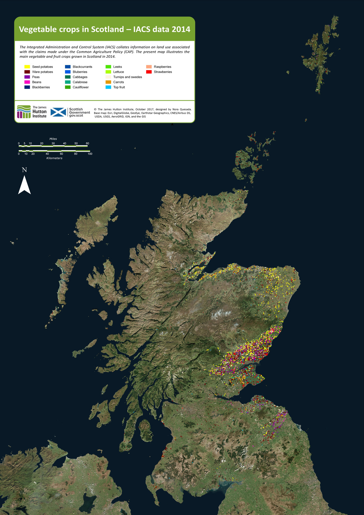
As background to the recent Vegetable Summit, held in Edinburgh, London and Cardiff, Nourish Scotland [1] asked the James Hutton Institute if it was possible to define the places where vegetables are grown in the region. The resulting map, prepared by Nora Quesada, is shown below.
Click on the map to open a larger version in a separate tab
Each coloured dot on the map indicates a field of fruit or vegetables. (The dots are much larger than individual fields.) It is clear from the distribution of dots that relatively little land exists in Scotland on which vegetables and fruit are grown. Even in places where the coloured dots are concentrated, the land area covered by fruit and vegetables is generally less than a few percent. Most of the other cultivated land is under cereals, wheat and barley.
Why do we want to know where vegetables are grown? Questions around diet, health and food poverty at this time of agricultural plenty were raised in a recent issue of Nourish Scotland’s magazine, January 2017, with the title ‘What would Boyd Orr do?’ [2].
John Boyd Orr was a pioneer of research into nutrition in Scotland many decades ago. His work became known throughout the world. The article asked what he would do today faced with the situation that, while vegetables are essential for a healthy human diet, most are imported and fail to reach the people that need them.
It is important to know therefore whether more land than shown on the maps can be converted to growing vegetables? For example, how much land would be needed to provide an optimum (rather than minimum) diet for the whole country from local produce; and can the cities be supplied with fruit and veg by the land surrounding them?
To answer such questions, it is necessary, first, to know what is grown and where. That is the purpose of the present mapping.
How is it done?
The EU’s Integrated Administration and Control Systems (IACS), which is used to manage farm subsidies, collects data on the crops grown on each field. The Scottish Government provided that information to the James Hutton Institute. Each field in IACS is geo-referenced and can be located on a base map that is of high enough resolution to show the outlines of the fields. The IACS reference then allows the fields on the base map to be linked to specific crops in specific years. This is how the maps shown in this article were constructed [3].
The IACS system does not account for vegetables from gardens and allotments and inner city and rural small scale production. There is much activity at these small scales, which we’ll look at in future posts.
Here we consider two examples of areas where vegetables are now produced: Strathmore and Angus and then Moray, Cromarty and Tarbat. Commercial growing needs good soil and a not-too-extreme climate, and given the difficulty of finding this combination in Scotland, it becomes apparent that today’s vegetable-producing regions have had strategic importance for hundreds and even thousands of years.
Strathmore and Angus
The main area for production of vegetables lies in Strathmore (map below), which stretches over a generally lowland region, from east of Perth and then in a north-east direction to the coast north of Angus. Angus itself is a major source of fruit and many types of vegetable. Across the Tay, parts of Fife are similarly productive.
The crops occupying the greatest surface area are still the cereals – barley and wheat – but they are not shown on the map. In addition to potato and a wide range of vegetables, this area is the centre of fruit growing in Scotland – strawberries, raspberries and blackcurrants.
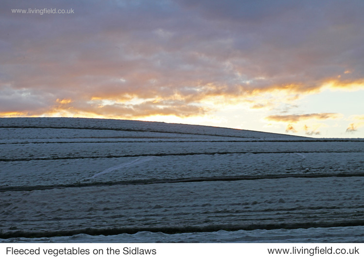
Increasingly in recent decades many vegetables are sown in the field then covered with a protective fleece to encourage early growth and to distance them from pests. Similarly, most soft fruit growing today is under the protection of polytunnels, where again the environment is less severe in winter and pests can be regulated.
Strathmore, Angus and Fife showing approx. locations of fields growing vegetables in one year.
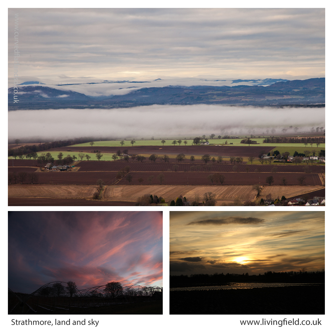
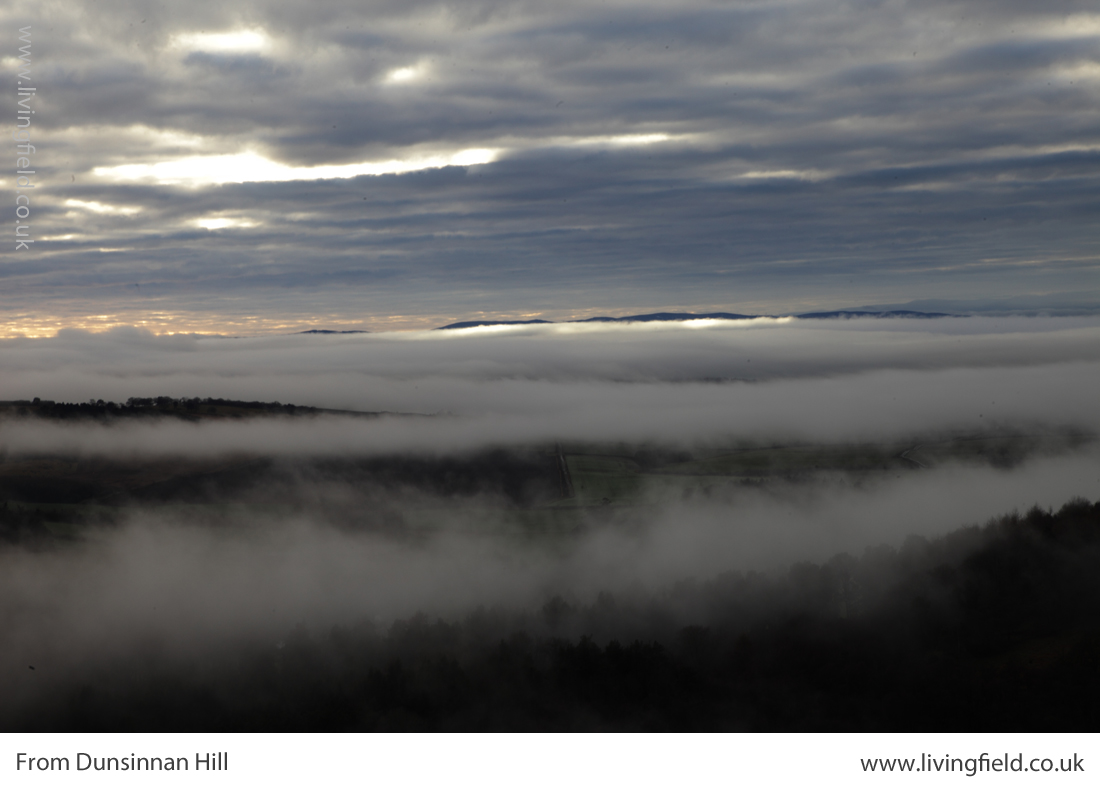
The fertile soils and maritime climate here were of strategic importance to the iron age communities who built their many hill forts along the Sidlaw Hills that form a barrier between Strathmore and the estuary and coast to the south. The famous Dunsinane, or Dunsinnan as it is referred to on old local maps, is one of them [4]. One of the photographs shown below was taken from Dunsinnan, north across Strathmore.
Later the Romans invaded, moving north from the region of Hadrian’s Wall, not finding much of a welcome it seems, and erecting forts and watchtowers along the Gask Ridge and in a line just within but near the northern extremity of the cloud of coloured dots in the image above [5].
The Romans’ massive Legionary Fortress at Inchtuthil, within the northern boundary of the strath (see map above), was built and deserted in the 1st Century AD, and was probably sited to guard the passes north along what is today’s A9. The fortress and marching soldiers would have needed constant supplies of food, and probably achieved this by access to the rich land of Strathmore.
From Dunsinnan Hill north across Strathmore (top), the Isla in flood at the the last sunset of the year (lower r) and winter sky above polytunnel frames (www.livingfield.co.uk)
The image at the top of the three above was taken from Dunsinnan early in year, looking across Strathmore. The nearest fields are still in stubble after last year’s harvest; the intermediate ones, showing rich brown soil, have been ploughed; and the green ones just beneath the low cloud were sown the previous autumn with winter cereals or oilseeds. The Roman line stretched this side of the hills.
Centuries later, the Picts made this productive region integral to their southern kingdom in the 7th and 8th centuries. Many symbol stones and ‘pit- ‘ place names survive here from that time [6]. Some of the crops grown here today would not be known then – potato, for example, was yet to cross the Atlantic, and the other ‘root’ crops – turnip and swede – were probably unknown.
Yet Strathmore, Angus and Fife would have offered enough agricultural land to feed this civilisation with its basic grain and protein. You can see it was a prize that other peoples would want to take for their own – the Scots moving across from Ireland would have found little land of comparable quality on the west coast.
The Black Isle, Moray, Tarbat, Cromarty
A hundred miles directly north of Inchtuthil Fortress, across today’s passes of Drumochter and Slochd, the land falls to the coast and becomes productive again. The area (map below) grows fewer types of vegetable today than Strathmore, but grain and tuber yields remain high.
The coloured dots show that seed and ware potato were the commonest vegetables in this region, but interestingly carrot is also prevalent. Go back to the 1780s and the farmer/traveller Andrew Wight had this to relate when riding along the northern side of the Cromarty Firth [7]:
“….. that Robert Hall, the farm manager of Fowlis ‘introduced a crop, rare in Scotland and an absolute novelty in the north, which is carrot. ….. The farm-horses are fed on carrots instead of corn; and they are always in good condition.”
Andrew Wight visited the area as part of his survey of the Improvements in the late 1700s, but the rich coastal land here has a historical legacy stretching back centuries.
The map above shows the area around the Cromarty and Moray Firths, the Moray coast stretching to the right and the Black Isle left of centre.
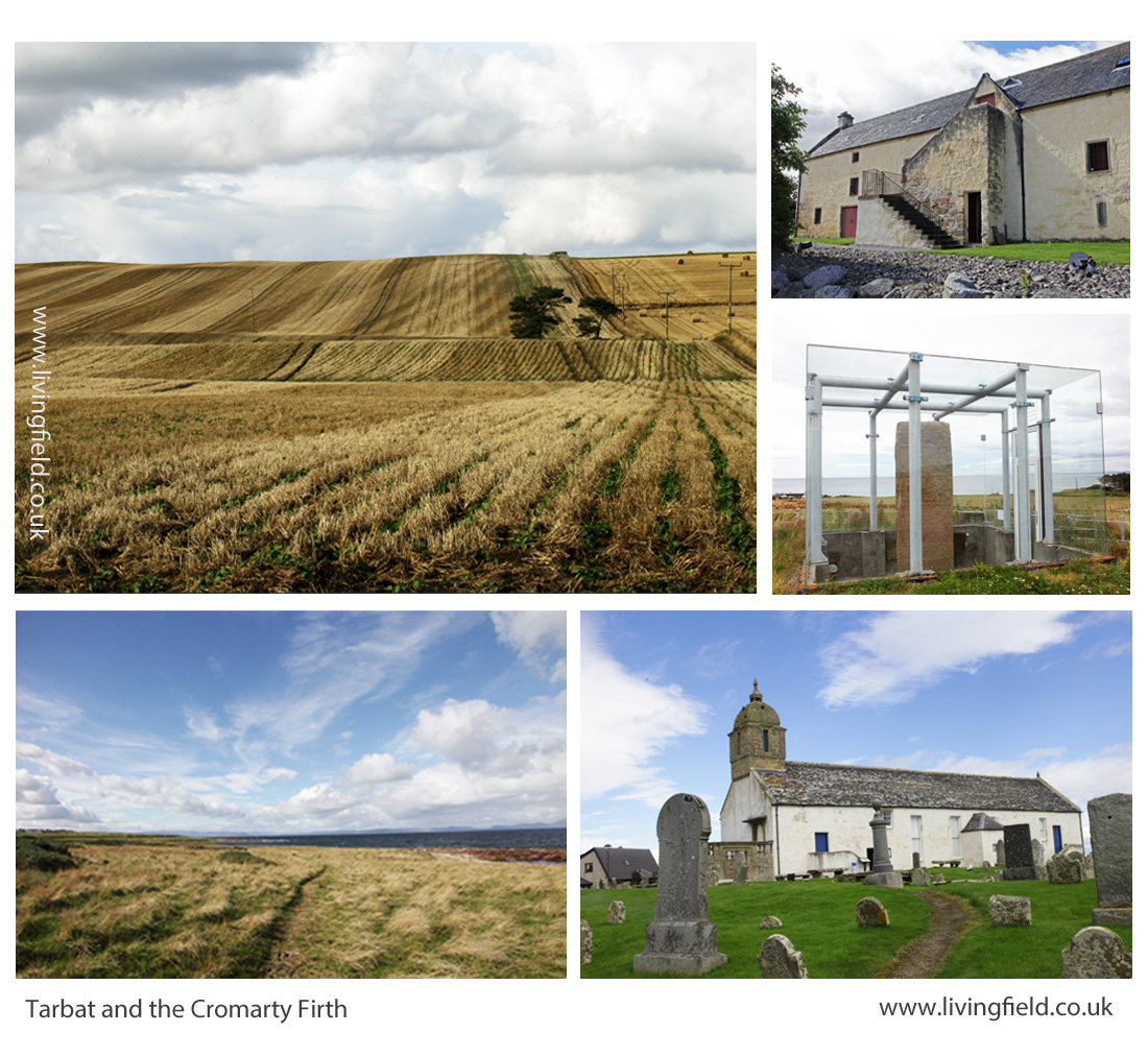
The northern Picts established their ‘elite’ farm and monastery at Portmahomack on the northern tip of the Tarbat peninsula. Their massive carved stones, at Nigg, Cadboll and Shandwick, were major contributions to European art. They arose within a civilisation based on the stability afforded by this good agricultural land [6].
As for Strathmore, the rich soil around the Dornoch and Cromarty Firths must have been eyed by the Scots from the west and the Norse from the east. Pictish civilisation, with its distinctive art and craft, did not survive.
Lines in the earth, Tarbat, including rapeseed drilled directly into cereal stubble (top left), then clockwise, the Storehouse of Foulis built in the 1700s; the Picts’ Shandwick Stone; site of the Tarbat Discovery Centre; and coastal grazing looking from Tarbat across the Dornoch Firth (www.livingfield.co.uk)
Opportunities
The maps derived from IACS data show the extent of vegetable growing today. Vegetables and fruit could be grown over a much wider area and a much higher density if the demand was there.
For example, the pulses – beans and peas – plants that fix their own nitrogen and so save on mineral fertiliser, have been reduced to a minor crop. The IACS map shows concentrations of peas and beans in the Borders, but overall the pulses cover less than 5% of the arable land. This is low by global standards. Countries that have transformed their agriculture in recent years now assign a quarter of their land to nitrogen-fixing crops.
Developments towards greater veg and fruit production and nitrogen fixing pulses will not be just though existing growers expanding their production. There are many local initiatives, some in areas considered inhospitable for vegetables. There is great scope therefore for increasing production but the demand for quality local produce has to be there from consumers.
Future posts on this web site will look at the value of fruit and veg to health, the degree to which Scotland depends (and it depends a lot) on imports for its fruit and veg, the new vegetable products that are appearing on the market (including beer and bread from beans), the increasing local initiatives in veg production and the possibilities for growing much more fruit and veg and making it available to those who need it.
For more on vegetables on the Living Field web site…
Next up –Veg at Bangkok markets, Thailand and Minerals and vitamins from vegetables and fruit.
From Dunsinnan, across Strathmore, early in the year 2017
Sources, links
[1] Nourish Scotland: The Vegetable Summit was held on 24 October 2017. For background see Peas Please – the Veg Project.
[2] What would Boyd Orr do? Nourish Scotland Magazine, Issue 6, January 2017. The link is to a pdf file. The article by Pete Ritchie explains John Boyd Orr’s contribution and his continuing relevance today. Other articles cover diet, food poverty, vegetables and right to food.
[3] IACS and map construction. Information of the Integrated Administration and Control System IACS scheme can be found at the web pages of the European Commission and the Scottish Government. Examples of a major exercise in mapping based on IACS data are given in a CAP Greening Review carried out by the James Hutton Institute for Scottish Government, published 2017: for links to the multi-part documentation, see CAP Greening Review on the SG web site; the section on mapping is Part 3 – Maps by David Miller, Doug Wardell-Johnson and Keith Matthews. Maps of vegetable growing produced in the present article were prepared by Nora Quesada.
[4] Dunsinnan hill fort. The Canmore site gives a detailed description. A string of Iron Age ‘forts’ along the Sidlaw Hills south of Strathmore and just north of the flat, reclaimed coastal plain of the Carse of Gowrie, can be seen on the OS map of the area. Search for hill ‘forts’ by name. (Ps. Shakespeare promoted a different pronunciation – Dunsinane.)
[5] The exhibition Roman Empire – Power and People in 2015 at the McManus in Dundee was an invaluable introduction to life at the northern limits of the Roman Empire. The LF article Feeding the Romansgives some background on the land use around the line of fortifications along Strathmore. For comprehensive coverage of this northern Roman frontier: Woolliscroft, DJ, Hoffmann, B 2006. Rome’s first frontier – the Flavian occupation of Northern Scotland. The History Press (reprinted 2011).
[6] Carver, Martin (2016) Portmahomack: Monastery of the Picts. Edinburgh University Press. (2nd edition). Excavations of the farm and monastery are described. The Picts, flourishing between the 600s and 900s were part of a wider European culture . In their travels, they most likely imported various plants for use as food and medicinals, yet very little other than remnants of grain have survived. Maps in the book show the location of pit- place names.
[7] For Andrew Wight’s note on the innovative growing of carrots by the Cromarty Firth in the 1780s, see Great Quantities of Aquavitae II on this web site.