Pictish Beasts

By Kathryn Owen

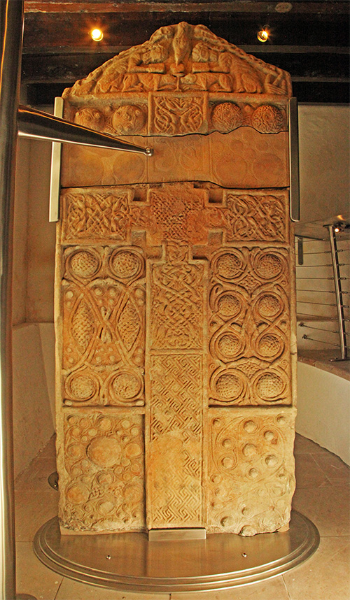
I think it was the great sculptured stone of Nigg that did it…… How could someone have carved a stone of that size, with such intricacy, such imagination and such skill with just a hammer and chisel? And 1200 years ago? 

The Pictish cross-slab in Nigg Church, Tarbat (www.livingfield.co.uk)

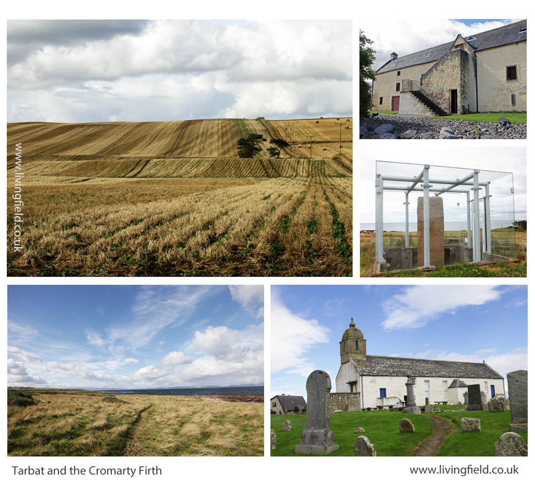
So that was how I became hooked on Pictish sculptured stones. I visited Tarbat Ness in Easter Ross and the beautiful little museum in St Colman’s Church at Portmahomack [1] to find more examples and history retold as a story. Martin Carver of York University began fieldwork on the site in 1994 [2]. The team uncovered extensive monastery grounds near a stone church probably dating from the 8th Century, with evidence of metalworking and vellum making but also many carved stones, all in pieces.

The evidence of vellum making indicates that a scriptorium (place for creating manuscripts and illustrated gospels) was in existence at that time. There is discussion at the moment too, as to whether the ‘Book of Kells’ [3] could possibly have been created, in part perhaps, at the monastery of Portmahomack. If true ……..now there’s a legacy!

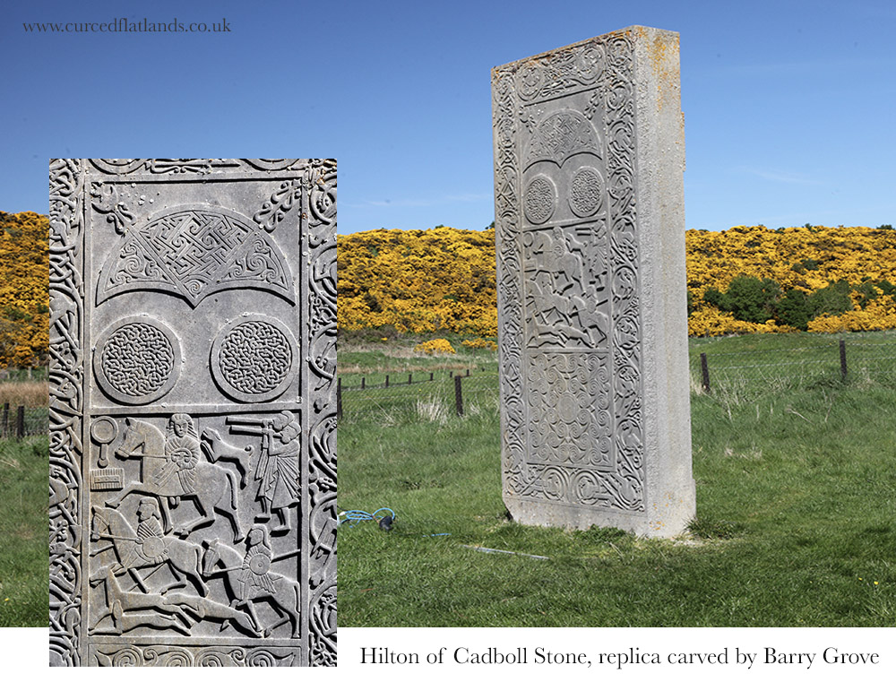
From there, I visited the other great Pictish sculptured stones of Tarbat Ness – the Hilton of Cadboll Stone and the Shandwick Stone [4]. There is a replica of the Hilton of Cadboll Stone, carved by Barry Grove [5] and now in its original position. The actual Stone is in the National Museum of Scotland in Edinburgh. The Shandwick Stone is covered by glass and is therefore protected from the elements, in place in the village of Shandwick. The Parish Church of Nigg houses the Nigg Stone, without glass, and it is the original – not a replica – and it is amazing!

Once I had seen these huge sculptured stones I began to find out more about both the Picts and their stones. Eastern Scotland is rich in its Pictish Stones, as is Morayshire, and there are so many to see, some in situ and some in museums. Some are well-protected but many are not – they are still in fields without even wooden structures to protect their artistry and their story. They are vulnerable to rain, snow, changing temperatures and the farmer’s plough.

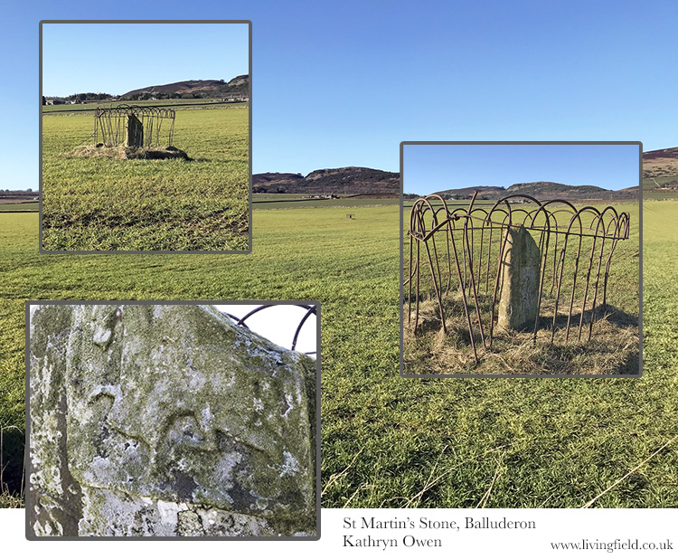
The stone in the photograph below, called St Martin’s Stone, is still in a field at Balluderon, Angus, exposed to the elements, and the sculpted figures and beasts are very faintly seen.  This monument, was created 1300 years ago but seems to be no longer respected as significant in 2022. The damaged rusty fence constructed around it may protect it from the plough or tractor, but not the weather. Should we not be doing more to protect these stones?

Iconography

I began seeking out Pictish Stones, taking photographs of the stones and their sites and recording the iconography of the stones. The stones have a wide range of symbols and strange motifs, of key patterns, or interlaced knotwork, of figures – many on horses, some clerical, some warriors, some musicians, and then there are the beasts! There are entwined sea horses, strange dragon-like animals, birds like eagles or ravens, angry limb-eating monsters and also the ‘Pictish Beast’. This beast is strange – it has a snout like a dolphin, a crest or mane like a horse, four weird appendages which could not really be called legs or fins and then a tail! It has sometimes been called the ‘elephant beast’, maybe because of its large trunk-like head.

One of my projects was to find as many Pictish Beasts as I could, photograph and draw and paint them. There is evidence that the stones had been painted after they had been sculpted. The colours of the paint would have been the basic dyes available to the sculptors at the time (e.g. woad, madder etc.). I like to think of my pictish beasts as being somehow toned with the blues, greens and yellows that remind me of sea reflections. I suppose I do see the pictish beast as a water animal but this is just an intuitive feeling about it! I have drawn about 10 beasts so far and there are about 50 odd altogether – so I have a long way to go.

Here are some of the ones I have completed so far, with details of the stones, where they can be found and any interesting points about them.

Rodney’s Stone – Brodie Castle in Morayshire

Rodney’s stone is a 2 m high cross slab located on the approach to Brodie Castle, originally found in the grounds of the old church of Dyke and Moy nearby. There is also an inscription in ogham alphabet [6] on the stone and this contains the name ‘Ethernan’ who was a Pictish Saint. 

Note that the Pictish beast has ornate interlacing on its body, not that usual.

Meigle, Perthshire

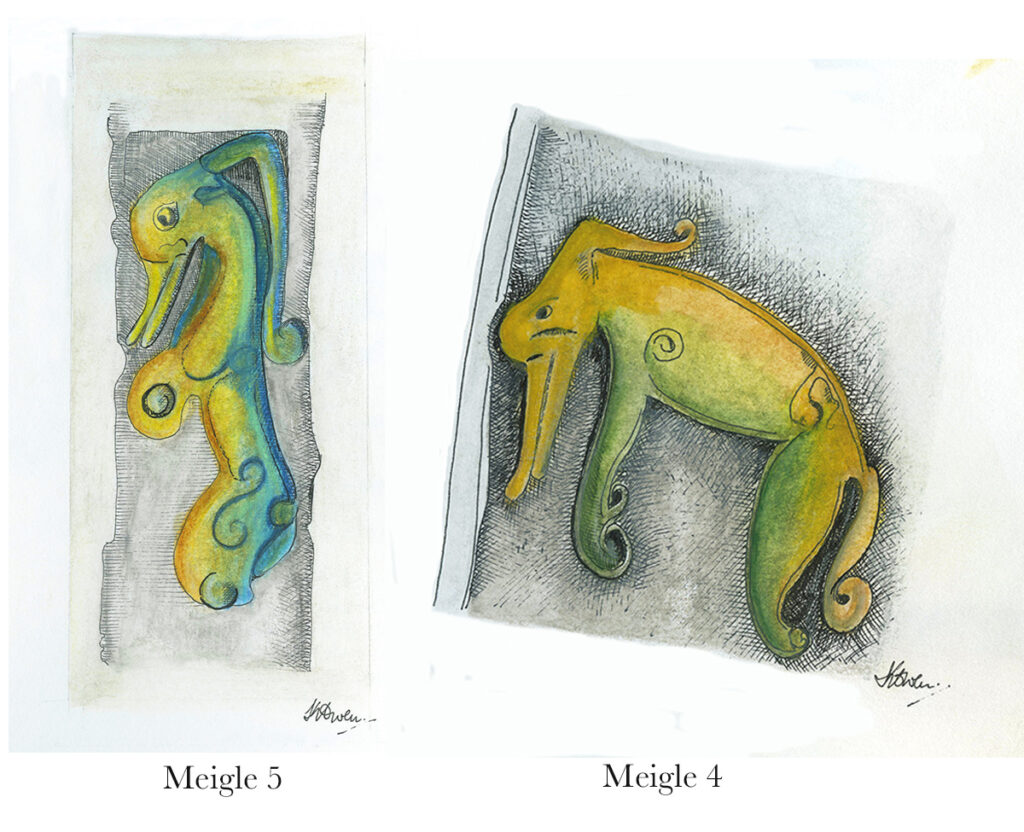
There is a great museum in Meigle in the former Parish School built in 1844 [7]. There is archeological evidence of an early church or monastery from 9th century. There are 27 Pictish stones and about a third of them are magnificent cross slabs and the stones are each numbered [4]. This Pictish beast (left below) is found on the side panel of Meigle 5 and looks fairly amused. The other – the grumpy one – is found on the reverse of the stone called Meigle 4.

Local Stones – McManus Museum, Dundee

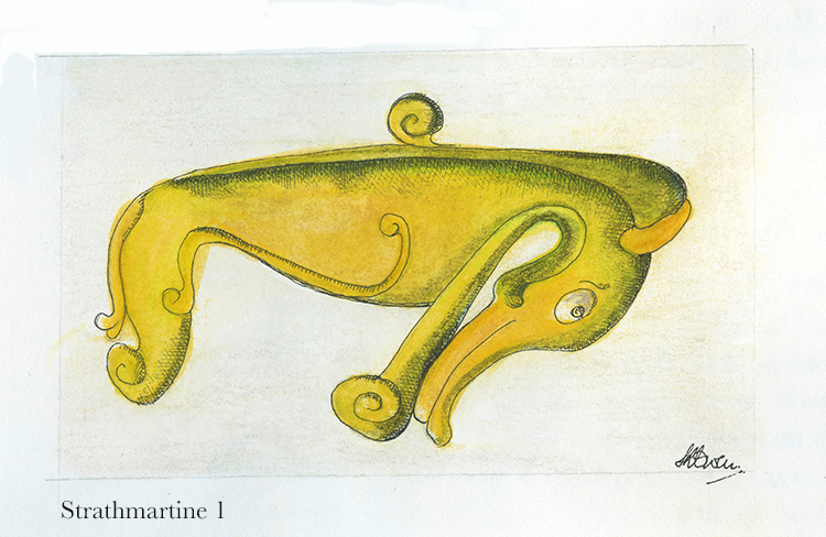
There have been a number of Pictish Stones found around Dundee and in Angus. I visited the local McManus Museum and also the Meffan Institute in Forfar [8] and was delighted to see the large number of stones on display. Strathmartine is an area of Dundee to the north west of the city where stones have been found on farmland. A pictish beast is found on Strathmartine 1, 3 and 6 [4]. This one is Strathmartine 1 and was found in a field between Strathmartine Castle and Gallow Hill. 

Aberlemno, Angus

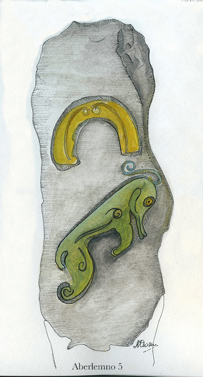
This stone of a pictish beast with a horse shoe above it was found in Aberlemno in the 1960s, again in a field. Aberlemno has a collection of outstanding Pictish stones, simply standing at the side of the road and in the grounds of the parish church. Another stone has recently been found in a nearby field during an archeological dig by Aberdeen University. A visit to Aberlemno really is inspiring to see these stones in situ, along the roadside and in the graveyard of Aberlemno Kirk [9].

Rossie Priory, Perthshire

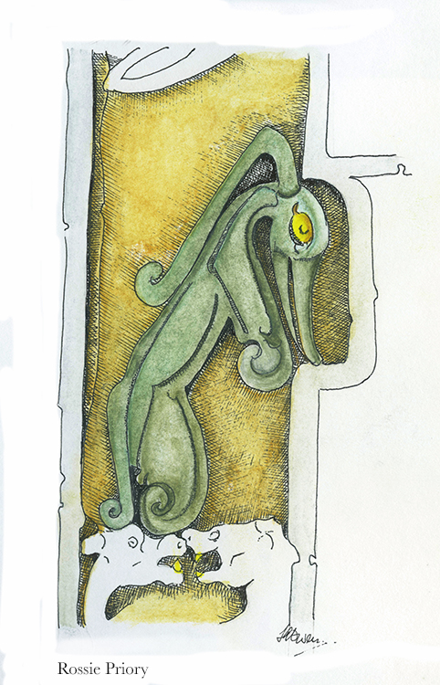
The Rossie Priory Stone in Perthshire is  protected in a family mausoleum. It is another highly carved, ornate and artistic stone and this beast is part of it. The heads below the beast are of a two-headed dog.

The Nigg Stone, Easter Ross

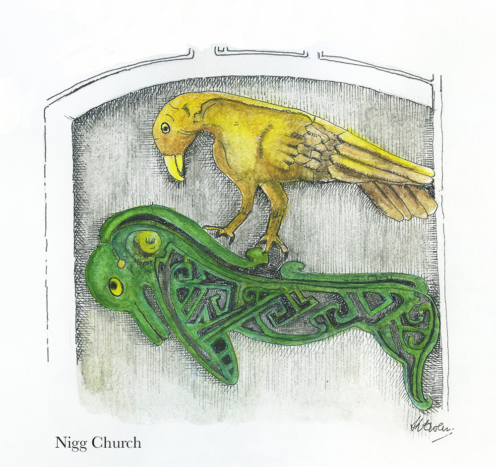
The Nigg Stone was broken in the 1800s when it was being moved and later repaired with a steel frame and an insert. The missing part on the reverse side of the stone had a Pictish beast and bird sculpted upon it. We know this from a drawing by Charles Petley in 1811/12.

I attempted to recreate this image of the beast from faint sketches found on Canmore [4] and in the Tarbet Ness Discovery Centre at Portmahomack [1], but also added in the interlacing that was in the original. I have found, so far, only two pictish beasts that contain interlacing and these are Rodney’s Stone and Nigg Stone. My drawing (below) shows an eagle above the beast and there are other stones where an eagle is below a pictish beast. There seems to be a relationship between these two – the eagle and the beast – but what?

More to be found

There are more pictish stones being discovered by various enthusiasts and professional archeologists as we move through 2022 into 2023. Recent finds include those at Aberlemno in 2021 [9] and Kilmadock in September 2022 [10].

Pictish Hill Forts are being futher excavated such as those at Burghead in Moray [11] to reveal great fortifications and more Pictish artifacts.

I hope more pictish beasts will be revealed but I have a long way to go to photograph, draw and paint all of them. Maybe I will not finish the task, but it’s a fascinating project so far!

Finally, details of the various beasts, the beautiful interlacing and key patterns can be found in the book by George Bain [12]. Bain describes and draws detail from Hilton of Cadboll, Shandwick and Nigg Stones but also instructs and guides readers into the art of Celtic design and construction. This is a great book for anyone wanting to learn more about the art of celtic drawing. 

Sources | links

[1] St Colman’s Church is now the site of the Tarbat Discovery Centre, Portmahomack, Easter Ross, which gives history of the site and wider area, and displays stones found locally.

[2] Portmahomack Monastery of the Picts, 2nd edition 2016, by Martin Carver. Edinburgh University Press.

[3] Book of Kells: see Trinity College Dublin at Shine a light on Irish history and the National trust for Scotland at The Book of Kells. The possibility that the Book could have been produced at an eastern Scottish monastery is considered by Victoria Whitworth (link to the Tarbat Discovery Centre).

[4] Photographs, drawings and information on Pictish Stones can be found by searching the Canmore web site (National Record of the Historic Environment) and in books, for example: Allan, J. Romilly and Anderson, J. 1903. The early Christian Monuments of Scotland, Vols 1 and 2. Society of Antiquaries of Scotland, Edinburgh. Numbering of the stones, useful where several are found or exhibited at the same site, usually follows that set by Romilly Allan.

[5] Barry Grove, sculptor: see the Halfmoon.tripod web site at The modern Pictish Stones of Barry Grove (Ed: link broken when checked 2 Oct 2022; same 29 Nov 2022) and the ARCH web site for an article by Susan Kruse Carving Pictish Stones.

[6] Ogham – an early mediaeval alphabet from Ireland. See the web sites: OG(H)AM for a current research project; articles by David Stifter, Maynooth University, e.g. Language and epigraphic culture ‘OGAM’; and ogham.co for history, symbols and translations.

[7] Meigle Sculptured Stone Museum at Historic Environment Scotland.

[8] McManus Art Gallery and Museum, Dundee and the Meffan Institute, Forfar (link to Angus Alive)).

[9] Aberlemno – Historic Environment Scotland web at Aberlemno Sculptured Stones. More at the web pages of Aberlemno Kirk – the Stones. YouTube video Rare Pictish symbol stone found near site of ancient battle.

[10] Kilmadock – stone found by ROOK Rescuers of Old Kilmadock (link to their facebook page).

[11] Burghead excavation, Moray – University of Aberdeen web at Scotland’s largest Pictish Fort and the Burghead Visitor Centre.

[12] Celtic Art The Methods of Construction, by George Bain, Constable and company first impression 1951.

Editor: many thanks to Kathryn Owen for sharing her experiences and drawings of Pictish Beasts. Pictish art is a legacy of global significance, originating in our croplands but appreciated far beyond.

For more art and craft at the Living Field – Ancient and modern – techniques with wool in textile art by Ruth Black, Repurposing grass pea as an embroidered textile and hand made paper by Caroline Hyde-Brown, Owlbirds by Kit Martin, and pages on this site by Jean Duncan and Tina Scopa.

Bere country

A note in the Bere-line – a survey of bere barley, an old corn landrace. Distribution of bere and barley in the 1850s: bere to the north and west, barley to the east and centre. Loss of bere and many other crops from the late 1800s. Declines in crop diversity. 

Previous notes in the bere-line compared bere barley and the improved two-row barleys in several collections and census records from the 1800s. By the 1850s, bere was still recognised and catalogued in terms of several variants [1] but most named types of barley were of the two-row form.

In the crop census of 1854 [2, 3], itself a milestone in the description of agriculture, bere occupied about 10% of the area of barley, but was still recorded throughout the country.

Distribution of bere in the 1850s

The census of 1854 was based on the pre-1890s counties, administrative areas that had been in existence, though not unaltered, for many hundreds of years [4, 5]. A map of the counties is shown at Sources below.

The areas sown with bere and barley in 1854 are shown in Fig. 1. The centre of each circle is positioned near the centre of one of the old counties. The map is partitioned into present administrative areas [6].

The area of each circle represents the relative area of crop in each county. The largest circle in the bere map is about 3000 acres (1,200 hectares) while the largest on the barley map is 28,000 acres (11,300 hectares). The map appears to show no or little bere or barley was grown in the western islands, but they were part of mainland counties at that time, so the crops grown there were included within circles  located on the mainland.

Fig. 1 Distribution of bere (left) and barley (right) from the 1854 census, each circle representing the area of crop in one of the pre-1890s counties. The largest bere circle is about ten times smaller than the largest barley. The dashed line near the top indicates Shetland is displaced downwards in this depiction. Orkney and Shetland formed one area in the census: bere on the left represented by the large circle just above Orkney; the arrow on the right pointing to the small area grown with barley. Click on the map to see a larger image. Original map outline from [6]. Source of data [3].

The distribution of bere confirms it was grown country-wide, from the Borders to Orkney and Shetland. Yet the areas sown to bere were very small in counties to the east and south east. It seems to have almost faded out in these places but remained strong in the north in Caithness, in the south-west in Argyll and in the northern islands, Orkney and Shetland. Bere was therefore grown in colder, wetter climates and poorer soils than could be profitably grown with the two-row types.

At this time, barley was the preferred crop in the east central and south east, which are now the typical, high-yielding grain producing regions of the country. Barley was not the major cereal in the 1800s. Oat was still grown over a much greater area. But the regions occupied by barley in the 1850s are those in which it rose to dominance in the period 1940-1960 to become by far the most widely grown cereal.

Bere’s decline

One of the main difficulties with charting the fall of bere is the absence of reliable records before and in the early 1800s.  Even its decline into the early 1900s is obscure because barley and bere were combined in the annual census of area and yield [7]. 

The reasons for bere’s later decline to near extinction are uncertain and would have differed between regions. The improving two-rowed barleys were probably easier to manage and more reliable yielders than bere in most parts of the country. There were regional variations – in Shetland, for example [10] the barleys as a whole declined fourfold from 1890 to 1930 and then continued to fall due to a rise in rotational grass and sheep.

Many changes occurred in the 150 years from the 1854 census, including major reductions of other crops – other than grass – grown for animal feed, including turnips and swedes, forage (leaf ) brassicas, grain legumes and mashlum, a traditional crop mix of oats and beans [8]. The loss of bere was part of that change. 

Yet bere did not die out. This traditional landrace is still grown and finding high-value uses in food and drink [9, 10]. There’s hope still – buy some bere meal and get cooking!

Author/contact: geoff.squire@hutton.ac.uk. Gladys Wright and Jackie Thompson grow the bere and barley crops in the Living Field Garden.

Sources, references, links

[1] Lawson and Sons synopsis of the vegetable products of Scotand: Bere in Lawsons synopsis of 1852.

[2] Highland and Agricultural Society of Scotland. For history and archives: https://archive.rhass.org.uk://archive.rhass.org.uk

[3] Thorburn T. 1855. Diagrams, Agricultural Statistics of Scotland for 1854. London: Effingham Wilson. More at this Living Field article on Thorburn’s Diagrams. Original available in part through the web. 

[4] The Historic Counties Trust and the Historic Counties Borders project: http://www.county-borders.co.uk/historiccountiestrust/index.html. See also Great Britain and Ireland – interactive county map at https://wikishire.co.uk/map/ 

[5] Shires of Scotland (Scotland historic counties before 1890) https://en.wikipedia.org/wiki/Shires_of_Scotland gives the history of the counties and map. The map opposite showing counties by number, except Orkney and Zetland (as it was then named) is from Undiscovered Scotland at Scottish Counties until 1890.

[6] Scotland map, outline with modern administrative regions: www.d-maps.com, free map, edited by the author.

[7] Agricultural Statistics 1912. Acreage and live stock returns of Scotland. Board of Agriculture for Scotland. HMSO. A useful starting point since it gives crop-areas back to 1902.

[8] Bean-oat or pea-oat mixed crop – an article on the Living field web site at Mashlum – a traditional mix of oats and beans.

[9] See Barony Mills’s web site  for preparation and uses of bere meal:  http://www.birsay.org.uk/baronymill.htm. The Living Field web site offers several of Grannie Kate’s recipes for bere meal, usually mixed with other cereals: seeded oatcakes with beremeal, bere bannocks, bere shortbread and bere scones.

[10] For a summary of cereal growing on Shetland, its decline and potential: Martin, P. 2015. Review of cereal growing in Shetland. Agronomy Institute, Orkney College. To find the PDF online, search for ‘cereal shetland agronomy institute 2015″.

Links to other Living Field articles on bere

The bere line – rhymes with hairline : summary of all links to bere on this site.

Landrace 1 – bere : notes on the barley landrace and crops on Orkney.

The horizontal water mills at Huxter: Shetland’s horizontal water mills.

Can we grow more vegetables?

Vegetables and fruit in Scotland mapped. Regions of historically strategic land and soil. The Iron Age, then the Romans, Picts and 1700s Improvers. Imports vs local production. Opportunities.

As background to the recent Vegetable Summit, held in Edinburgh, London and Cardiff, Nourish Scotland [1] asked the James Hutton Institute if it was possible to define the places where vegetables are grown in the region. The resulting map, prepared by Nora Quesada, is shown below.

Click on the map to open a larger version in a separate tab

Each coloured dot on the map indicates a field of fruit or vegetables. (The dots are much larger than individual fields.) It is clear from the distribution of dots that relatively little land exists in Scotland on which vegetables and fruit are grown. Even in places where the coloured dots are concentrated, the land area covered by fruit and vegetables is generally less than a few percent. Most of the other cultivated land is under cereals, wheat and barley.

Why do we want to know where vegetables are grown? Questions around  diet, health and food poverty at this time of agricultural plenty were  raised in a recent issue of Nourish Scotland’s magazine, January 2017, with the title ‘What would Boyd Orr do?’ [2].

John Boyd Orr was a pioneer of research into nutrition in Scotland many decades ago.  His work became known throughout the world. The article asked what he would do today faced with the situation that, while vegetables are essential for a healthy human diet, most are imported and fail to reach the people that need them.

It is important to know therefore whether more land than shown on the maps can be converted to growing vegetables? For example, how much land would be needed to provide an optimum (rather than minimum) diet for the whole country from local produce; and can the cities be supplied with fruit and veg by the land surrounding them?

To answer such questions, it is necessary, first, to know what is grown and where. That is the purpose of the present mapping.

How is it done?

The EU’s Integrated Administration and Control Systems (IACS), which is used to manage farm subsidies, collects data on the crops grown on each field. The Scottish Government provided that information to the James Hutton Institute. Each field in IACS is geo-referenced and can be located on a base map that is of high enough resolution to show the outlines of the fields. The IACS reference then allows the fields on the base map to be linked to specific crops in specific years. This is how the maps shown in this article were constructed [3].

The IACS system does not account for vegetables from gardens and allotments and inner city and rural small scale production. There is much activity at these small scales, which we’ll look at in future posts.

Here we  consider two examples of areas where vegetables are now produced: Strathmore and Angus and then Moray, Cromarty and Tarbat. Commercial growing needs good soil and a not-too-extreme climate, and given the difficulty of finding this combination in Scotland, it becomes apparent that today’s vegetable-producing regions have had strategic importance for hundreds and even thousands of years.

Strathmore and Angus

The  main area for production of vegetables lies in Strathmore (map below), which stretches over a generally lowland region, from east of Perth and then in a north-east direction to the coast north of Angus. Angus itself is a major source of fruit and many types of vegetable. Across the Tay, parts of Fife are similarly productive.

The crops occupying the greatest surface area are still the cereals – barley and wheat – but they are not shown on the map. In addition to potato and a wide range of vegetables, this area is the centre of fruit growing in Scotland – strawberries, raspberries and blackcurrants.

Increasingly in recent decades many vegetables are sown in the field then covered with a protective fleece to encourage early growth and   to distance them from pests. Similarly, most soft fruit growing today is under the protection of polytunnels, where again the environment is less severe in winter and pests can be regulated.

Strathmore, Angus and Fife showing approx. locations of fields growing vegetables in one year.

The fertile soils and maritime climate here were of strategic importance to the iron age communities who built their many hill forts along the Sidlaw Hills that form a barrier between Strathmore and the estuary and coast to the south. The famous Dunsinane, or Dunsinnan as it is referred to on old local maps, is one of them [4]. One of the photographs shown below was taken from Dunsinnan, north across Strathmore.

Later the Romans invaded, moving north from the region of Hadrian’s Wall, not finding much of a welcome it seems, and erecting forts and watchtowers along the Gask Ridge and in a line just within but near the northern extremity of the cloud of coloured dots in the image above [5].

The Romans’ massive Legionary Fortress at Inchtuthil, within the northern boundary of the strath (see map above), was built and deserted in the 1st Century AD, and was probably sited to guard the passes north along what is today’s A9. The fortress and marching soldiers would have needed constant supplies of food, and probably achieved this by access to the rich land of Strathmore.

From Dunsinnan Hill north across Strathmore (top), the Isla in flood at the the last sunset of the year (lower r) and winter sky above polytunnel frames (www.livingfield.co.uk)

The image at the top of the three above was taken from Dunsinnan early in year, looking across Strathmore. The nearest fields are still in stubble after last year’s harvest; the intermediate ones, showing rich brown soil, have been ploughed; and the green ones just beneath the low cloud were sown the previous autumn with winter cereals or oilseeds. The Roman line stretched this side of the hills.

Centuries later, the Picts made this productive region integral to their southern kingdom in the 7th and 8th centuries. Many symbol stones and ‘pit- ‘ place names survive here from that time [6]. Some of the crops grown here today would not be known then – potato, for example, was yet to cross the Atlantic, and the other ‘root’ crops – turnip and swede – were probably unknown.

Yet Strathmore, Angus and Fife would have offered enough agricultural land to feed this civilisation with its basic grain and protein. You can see it was a prize that other peoples would want to take for their own – the Scots moving across from Ireland would have found little land of comparable quality on the west coast.

The Black Isle, Moray, Tarbat, Cromarty

A hundred miles directly north of Inchtuthil Fortress, across today’s passes of Drumochter and Slochd, the land falls to the coast and becomes productive again. The area (map below) grows fewer types of vegetable today than Strathmore, but grain and tuber yields remain high.

The coloured dots show that seed and ware potato were the commonest vegetables in this region, but interestingly carrot is also prevalent. Go back to the 1780s and the farmer/traveller Andrew Wight had this to relate when riding along the northern side of the Cromarty Firth [7]:

“….. that Robert Hall, the farm manager of Fowlis  ‘introduced a crop, rare in Scotland and an absolute novelty in the north, which is carrot. ….. The farm-horses are fed on carrots instead of corn; and they are always in good condition.”
Andrew Wight visited the area as part of his survey of the Improvements in the late 1700s, but the rich coastal land here has a historical legacy stretching back centuries.

The map above shows the area around the Cromarty and Moray Firths, the Moray coast stretching to the right and the Black Isle left of centre.

The northern Picts established their ‘elite’ farm and monastery at Portmahomack on the northern tip of the Tarbat peninsula. Their massive carved stones, at Nigg, Cadboll and Shandwick, were major contributions to European art. They arose within a civilisation based on the stability afforded by this good agricultural land [6].

As for Strathmore, the rich soil around the Dornoch and Cromarty Firths must have been eyed by the Scots from the west and the Norse from the east. Pictish civilisation, with its distinctive art and craft, did not survive.

Lines in the earth, Tarbat, including rapeseed drilled directly into cereal stubble (top left), then clockwise, the Storehouse of Foulis built in the 1700s; the Picts’ Shandwick Stone; site of the Tarbat Discovery Centre; and coastal grazing looking from Tarbat across the Dornoch Firth (www.livingfield.co.uk)

Opportunities

The maps derived from IACS data show the extent of vegetable growing today. Vegetables and fruit could be grown over a much wider area and a much higher density if the demand was there.

For example, the pulses – beans and peas – plants that fix their own nitrogen and so save on mineral fertiliser, have been reduced to a minor crop. The IACS map shows concentrations of peas and beans in the Borders, but overall  the pulses cover less than 5% of the arable land. This is low by global standards. Countries that have transformed their agriculture in recent years now assign a quarter of their land to nitrogen-fixing crops.

Developments towards greater veg and fruit production and nitrogen fixing pulses will not be just though existing growers expanding their production. There are many local initiatives, some in areas considered inhospitable for vegetables. There is great scope therefore for increasing production but the demand for quality local produce has to be there from consumers.

Future posts on this web site will look at the value of fruit and veg to health, the degree to which Scotland depends (and it depends a lot) on imports for its fruit and veg, the new vegetable products that are appearing on the market (including beer and bread from beans), the increasing local initiatives in veg production and the possibilities for growing much more fruit and veg and making it available to those who need it.

For more on vegetables on the Living Field web site…

Next up –Veg at Bangkok markets, Thailand and Minerals and vitamins from vegetables and fruit. 

For the Living Field’s experiences with veg growing, see Vegetables in the Living Field Garden. For some health benefits, see Cornbread, peas and back molasses and 2 veg to pellagra. For random posts on pulses (peas and beans), see Feel the pulsePeanuts to pellagra and Scofu: the quest for an indigenous Scottish tofu.

From Dunsinnan, across Strathmore, early in the year 2017

Sources, links

[1] Nourish Scotland: The Vegetable Summit was held on 24 October 2017. For background see Peas Please – the Veg Project.

[2] What would Boyd Orr do? Nourish Scotland Magazine, Issue 6, January 2017. The link is to a pdf file. The article by Pete Ritchie explains John Boyd Orr’s contribution and his continuing relevance today. Other articles cover diet, food poverty, vegetables  and right to food.

[3] IACS and map construction. Information of the Integrated Administration and Control System IACS scheme can be found at the web pages of the European Commission and the Scottish Government. Examples of a major exercise in mapping based on IACS data are given in a CAP Greening Review carried out by the James Hutton Institute for Scottish Government, published 2017: for links to the multi-part documentation, see CAP Greening Review on the SG web site; the section on mapping is Part 3 – Maps by David Miller, Doug Wardell-Johnson and Keith Matthews. Maps of vegetable growing produced in the present article were prepared by Nora Quesada.

[4] Dunsinnan hill fort. The Canmore site gives a detailed description.  A string of Iron Age ‘forts’ along the Sidlaw Hills south of Strathmore and just north of the flat, reclaimed coastal plain of the Carse of Gowrie, can be seen on the OS map of the area. Search for hill ‘forts’ by name. (Ps. Shakespeare promoted a different pronunciation – Dunsinane.)

[5] The exhibition Roman Empire – Power and People in 2015 at the McManus in Dundee was an invaluable introduction to life at the northern limits of the Roman Empire. The LF article Feeding the Romans gives some background on the land use around the line of fortifications along Strathmore. For comprehensive coverage of this northern Roman frontier: Woolliscroft, DJ, Hoffmann, B 2006. Rome’s first frontier – the Flavian occupation of Northern Scotland. The History Press (reprinted 2011).

[6]  Carver, Martin (2016) Portmahomack: Monastery of the Picts. Edinburgh University Press. (2nd edition). Excavations of the farm and monastery are described. The Picts, flourishing between the 600s and 900s were part of a wider European culture . In their travels, they most likely imported various plants for use as food and medicinals, yet very little other than remnants of grain have survived. Maps in the book show the location of pit- place names.

[7] For Andrew Wight’s note on the innovative growing of carrots  by the Cromarty Firth in  the 1780s, see Great Quantities of Aquavitae II on this web site.

Contact

Text and background: geoff.squire@hutton.ac.uk

Mapping: nora.quesadapizarro@hutton.ac.uk

[Updated 2 December 2017  with revised main map.]

Fixers 3 Crimson clover

Third in a series on nitrogen fixing legume plants.

The crimson clover Trifolium incarnatum ssp incarnatum was once grown widely in the south of Britain and trialled in the north, where it never found favour as a forage ley compared to the white and red clovers. So a small field of mixed legumes in Tarbat, a few miles south  of Portmahomack, was unusual.

Crimson clover was the most visible of the plants, in full flower late September, but the patch also contained red clover, two white- flowered clovers and a few other plants. On its margins a stray sainfoin appeared, probably a relic from a previous sowing.

lf_ntsmgs_mxdlgms1_gs_1100

Crimson clover was noted in Lawson & Son’s Vegetable Products of Scotland  (1852). They report that, if sown in autumn, it can be cut in June the next year ‘…. and the land fallowed for wheat or spring corn’.  They report that is makes a valuable green food for cattle and when cut in full flower ‘it makes a more abundant crop, and a superior hay to that of common clovers, at least it is more readily eaten by horses’.

They also report a comparison of ‘common crimson clover’, a variety of it named ‘late-flowering crimson clover’ sourced from Toulouse in France, and Moliner’s clover which was said to be grown in France and Switzerland. The late flowering variety came out top.

In modern taxonomy, the only one of these native to Britain is now called long-headed clover Trifolium incarnatum ssp molinerii, white-flowered, but that is found at only a few coastal sites in the south of Britain. This is likely to be the same as the Moliner’s clover mentioned by the Lawsons, but their seed was most likely sourced from European seedsmen rather than from the wild in Britain. Crimson clover is now Trifolium incarnatum  ssp incarnatum. Moliner’s and crimson are therefore considered sub-species (ssp) of the same species.

So what was it doing here? It was probably sown in a clover mix as a legume contribution to CAP Greening measures (see Sources). As can be seen the mix was luxuriant in foliage and flower well into autumn, when many other wild plants were dying or seeding.

Tarbat is a rich agricultural region, and you can see why the Picts farmed and established their monastery and unique monuments here  over 1000 years ago. Today, small fields and patches like the one shown offer refuge and food for  insects and birds in a landscape dominated by grazing land, and harvested or ploughed fields.

lf_ntsmgs_mxdlgmns2_gs_1100

Sources

Peter Lawson and Son. 1852. Synopsis of the vegetable products of Scotland. Edinburgh: Private Press of Peter Lawson and Son

Mixtures for CAP Greening and also crimson clover alone: Cotswold Seeds https://www.cotswoldseeds.com/seed-info/greening-and-cap-reform

Taxonomy from: Stace C. 1997. New flora of the British Isles 2nd Edition.

Links to legumes on this web site:

Contact: geoff.squire@hutton.ac.uk. Images are the property of the Living Field project.