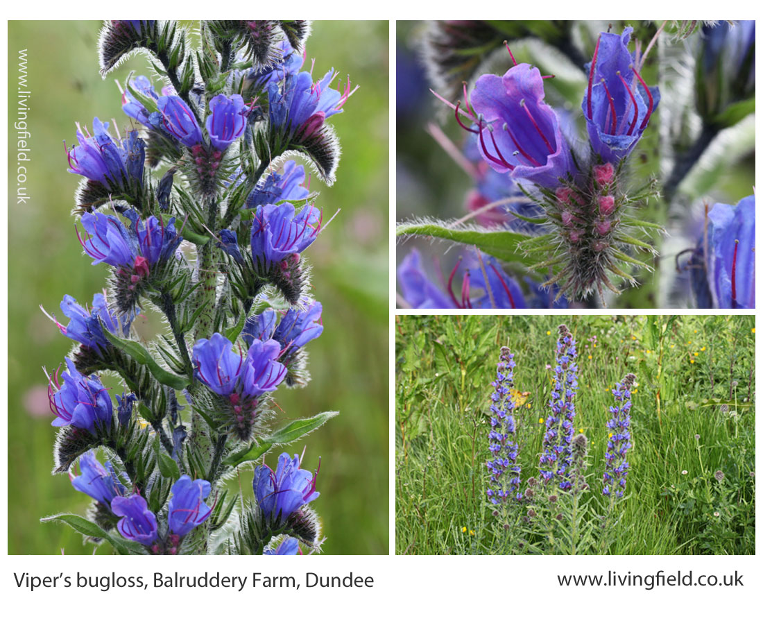
We’d taken a stem back from the field to examine it. It looked close to Viper’s bugloss Echium vulgare, similar flowers and habit (images below), another species of Echium probably. It was growing profusely among what first looked like a field of oat, in Victoria, Australia. Then our host, Mrs McPherson, who knew the plant well said ‘Paterson’s Curse‘ and it turned out to be one of the most noxious weeds.
Viper’s bugloss near the pond at the Institute’s Balruddery Farm, where it grows as a winter annual, germinating one year, overwintering and flowering the next.
The borage family, to which Viper’s Bugloss belongs, is hardly a weedy problem in the UK. In his book on arable weeds in Britain, written well before the intensification of agriculture after the 1950s, HC Long [1] lists viper’s bugloss, corn gromwell Lithospermum arvense, bugloss Anchusa arvensis and field forget-me-not Myosotis arvensis among the borage family weeds of the 1920s, but none were harmful. Today, only field forget-me-not is common in the arable seedbank [2] but is still not among the top ten troublesome cornfield weeds.
But in Australia …..
In pasture and arable
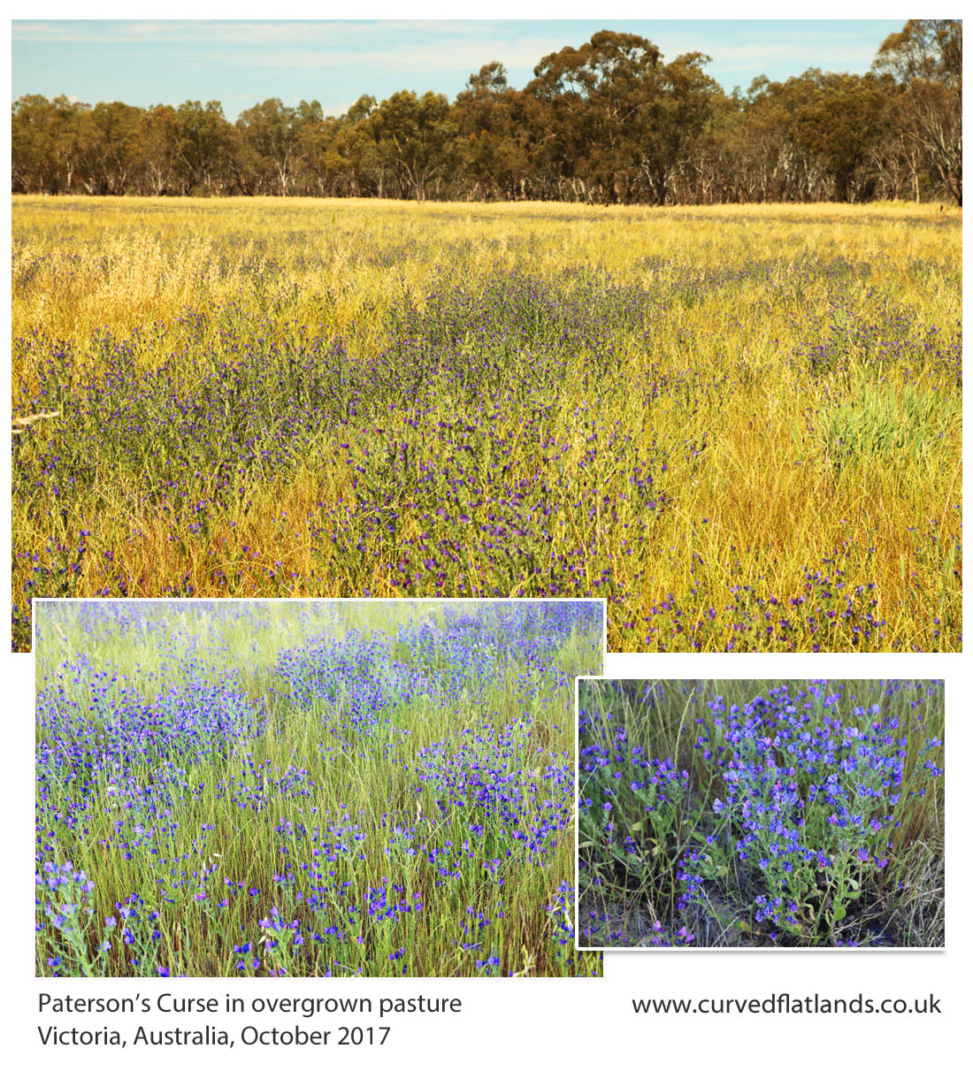
Paterson’s Curse Echium plantagineum remains a major invasive species and noxious weed of arable land in southern Australia, notably Victoria and New South Wales. It was not always there. It is from Mediterranean Europe and north Africa, but sometimes cultivated elsewhere as a garden plant for its blue flowers, for which it was taken to Australia. Then it spread uncontrollably [3].
Here it is in the photographs below, growing in what is most likely a field of ryegrass, along with probably oats that self-seeded after a previous crop. Paterson’s Curse is the blue-purple haze, growing in irregular lines and patches.
The plant is taken very seriously in south Australia as a weed of pasture and arable land. It competes for light, water and nutrient with crops and pasture plants, but is also a poison to some farm animals. It is a ‘declared plant’ listed in the Biosecurity and Agriculture Management Act 2007, and it is an offence to spread or transport it. Full descriptions are given, by national and state agriculture departments [3], including various means of biological control using invertebrates (e.g. insects).
It’s not all bad, however. Another of its common names, Salvation Jane, hints that it can assist in times of hardship, forming a constituent of pasture or hay that some stock animals can feed on, especially in dry seasons.
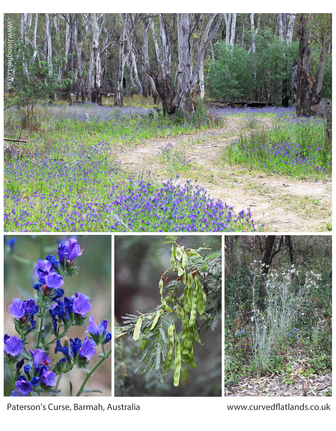
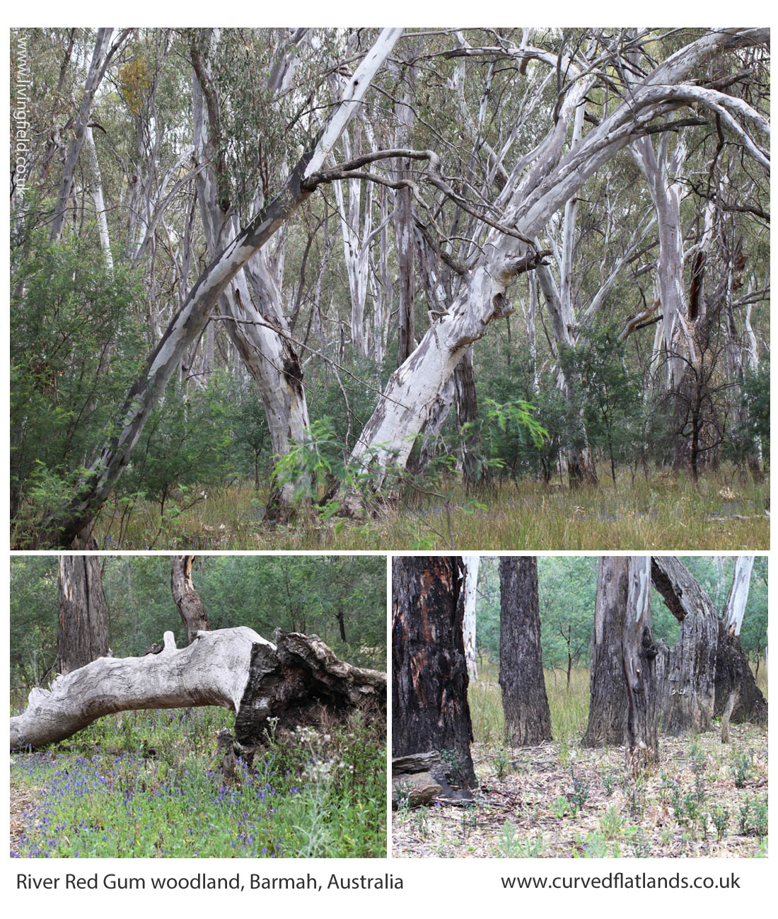
In flooded river red gum forest
The plant was also seen growing under the trees in a River Red Gum forest by the Murray River [4]. It was profuse, lining dirt tracks, but also spreading out underneath the shrub layer. There were other weeds with it, notably some of the composite, legume and nightshade families.
Paterson’s Curse lining tracks through river red gum and (lower) a flowering branch and two other understorey plants.
Away from the tracks and under the denser canopies, it was less common, but still the occasional plant was flowering and seeding.
Two years earlier, in the same month, there was no Paterson’s Curse to be seen here. Which raises questions as to how it became so abundant in 2017. Was it in the seedbank but did not germinate two years ago? If the seed was newly arrived in the area, how did it get there in such numbers?
There were extensive floods recently, and it may be that the seed was brought down the river or else the floodwater covered nearby agricultural fields and picked up seed as it receded, depositing seeds in the forest near the river. There are many potential means by which the plants could have spread.
Paterson’s Curse is a classic and costly example of a plant species that is barely an inconvenience in its native home, but finds spectacular opportunity in new territory. A bit like the rabbit and the fox. It’s no wonder Australia is cautious about its biological quarantine.
Do we have weeds as bad as this?
Britain certainly had its share of damaging weeds. Long [1] refers to the Corn Production Acts of the 1920s in which injurious weeds were named, and instructions given that they should be controlled, and if they were not, the landowner could be fined. He cites the counties of Surrey, Kent and Lancashire as having ‘shown very great energy in the matter’ of enforcing the Acts and bringing prosecutions.
The named weeds were ragwort, spear thistle, creeping thistle, curled dock and broad-leaved dock. Thirty years later the same weeds were still causing trouble and were named in the 1950s weed acts.
That was before chemical pesticides were routinely used and today the only one of them still spreading out of control is ragwort [5]. But interestingly, ragwort is spreading not in managed agricultural land but along main roads, motorways and roundabouts, and also into rough pasture and along some minor roads leading into wild land. The 1950s weed act still applies, so complaints can still be made about landowners encouraging ragwort to persist and spread [5].
Today, in Britain, and ragwort excepted, most botanical invasions are outside tilled agriculture and by perennial plants such as rhododendron and himalayan balsam (but that’s another story).
Sources, links
[1] Long, HC. 1929. Weeds of arable land. London: HMSO. Ed: Long wrote his book on arable weeds well before chemical control became the norm after the 1960s in the UK. His account is an essential guide to weeds and their management, mostly by cultivation and choice of crop, in the period before intensification of arable land between 1950 and 1990.
[2] The seeds dropped by plants and buried in the soil form what is called a seedbank. Depending on the species, the seeds can survive for many years and then germinate when they are brought to the surface and conditions are right for them. The seedbank is important for survival is vegetation that suffers periodic destruction – such as burnt grassland or forest and land disturbed for agriculture. If no opportunities arise for germination, the seeds eventually die and the plant can be locally extinct. Most of the borage plant family in Britain can form a seedbank, but conditions in tilled fields have not been favourable to them and with few exceptions, they are rare in farmland.
[4] Barmah National Park protects a river red gum forest Eucalyptus camaldulensis by the Murray River in Victoria, Australia. Information at Parks Victoria.
The historic watermill at Blair Atholl. Absence of corn growing in the surrounding area today. Extensive field systems and enclosed land in the mid 1700s. Andrew Wights 1780s descriptions of innovation, enterprise and crop diversification. Part of a Living Field series on old corn mills.
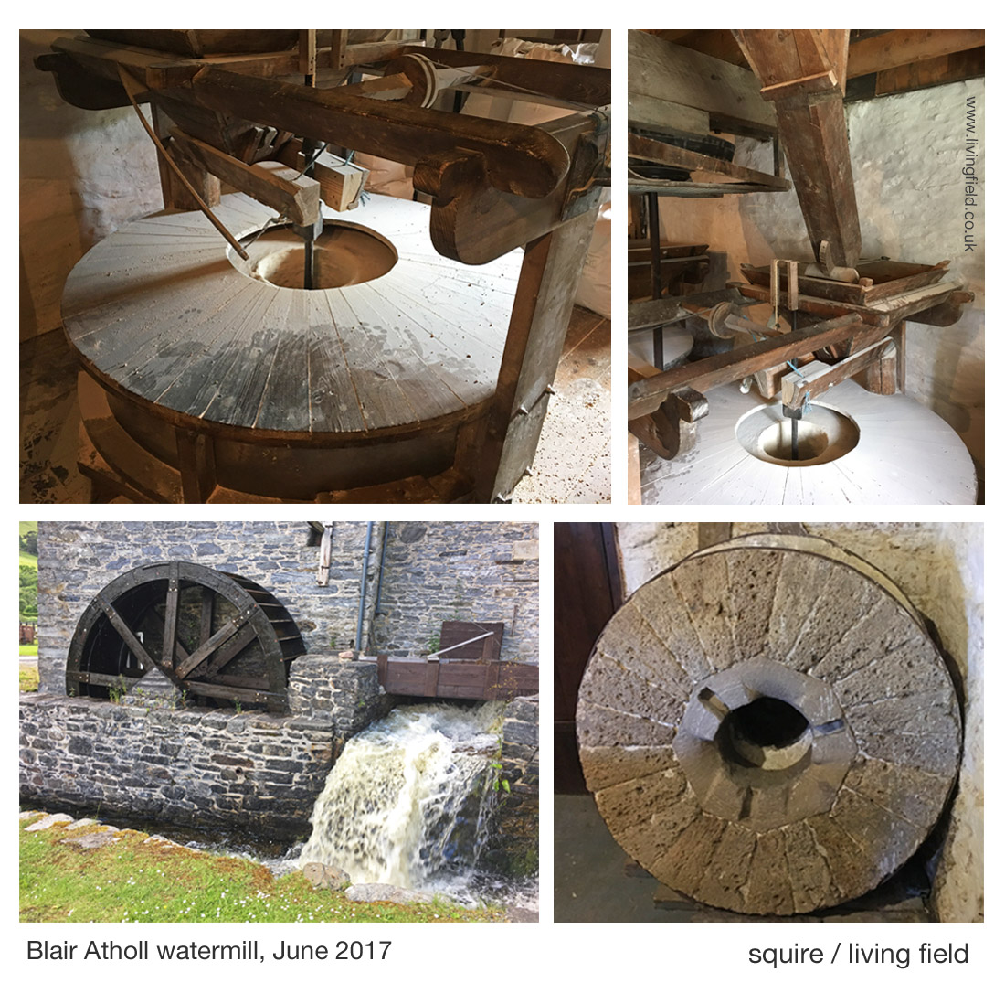
The watermill at Atholl [1] offers a welcoming break to journeys along the A9 road, offering – in addition to the working mill – coffee and freshly baked bread from a variety of grains. In 2017, the mill and its bakers gained some deserved exposure on a BBC2 television programme, Nadiya’s British Food Adventure, presented by Nadiya Hussain [1].
The remaining corn mills in the north of Britain tell much about the phasing in and out of local corn production over the last few centuries. The Living Field’s interest in this case lies in the mill’s history and location, being a substantial building but presently in an area that has no local corn production. In this, it differs from Barony Mills in Orkney which lies within an area of barley cultivation that still supplies the mill [2].
The images above show the water wheel fed by a lode that runs from the river Tilt to the north, the main grinding wheel (covered, top l), hoppers feeding the wheel and an old mill wheel. The watermill’s web site [1] and the explanation boards in the mill itself describe the history of the building and workings of the machinery.
The Atholl watermill was a substantial investment, but what strikes today is the absence of corn-growing (arable) land in the area. When visited in 2017, very few fields were cultivated.
What do the historical maps tell us?
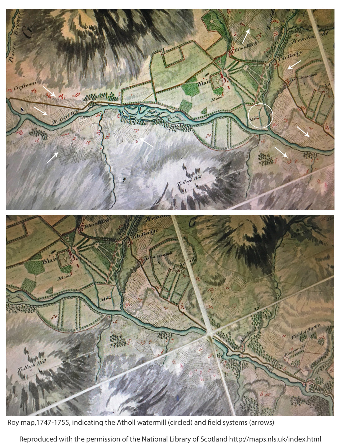
The information inside the mill states that it was present at the time of Timothy Pont’s map of the 1590s [3]. It is there on his map, just south of ‘Blair Castel’. But Roy’s Military Survey [4] of the mid-1700s gives the best indication of the possible extent of cropped land in the area. Features on the Roy map (copied below) include ‘Blair Kirk’ (church) which still stands at what is now known as Old Blair and ‘Tilt Bridge’ on the road that ran north of the Garry; then areas of enclosed land or parkland, bounded by tree lines; and the Mill, shown within the white circle in the upper map, with its lode clearly leaving the River Tilt to the north and flowing past the mill to enter the River Garry upstream of where the Tilt joins it.
The Roy Map shows what appear be clusters of field systems on both sides of the Garry, depicted by short parallel lines suggesting rigs, some indicated by white arrows on the upper map. The lower map has been displaced to show more field systems around Aldclune.
Later, on the first edition of the Ordnance Survey 1843-1882, the village of ‘Blair Athole’ has started to take shape, the corn mill is marked being fed by a Mill Lead originating at a sluice off the River Tilt. Later still, the Land Utilisation Survey 1931-1935 shows arable land remaining, consistent with the location of many of the field systems on Roy’s map.
Therefore crops, and they must have included corn, whether oat or barley, were grown in the region and presumably fed the mill, but more information on what was grown was reported by Andrew Wight, travelling 30 years or so after Roy.
Andrew Wight’s survey of 1784
Mr Wight’s surveys of agriculture in Scotland in the 1770s and 1780s again provide rare and sometimes surprising insights. He meets and reports on mainly the improvers, the landowners and their major tenants, less so the householder and small grower. Yet he was there at a crucial time in the development of food production and able to present a unique and consistent account throughout mainland Scotland.
Part way through his fourth survey [6], he spent the night in Dalwhinnie, then on travelling south towards lowland Perthshire, he stopped at Dalnacardoch, commenting that the innkeeper was a ‘spirited and enterprising’ farmer. There he reports a “clover field, dressed to perfection; an extraordinary sight in this barren country” and also “turnips in drills in perfect good order, pease broadcast, bear and oats with grass-seeds”, and notes ‘great crops of potato are raised here’. [Ed: bere is a landrace of barley.]
On ‘Athol House’ (near the mill) he concentrates on the animals, various breeds and hybrids of cattle, and also sheep; but on the tilled land, he writes the “Duke’s farm is about 700 acres arable; of which not more than 120 are in tillage, the rest being hay or pasture.” The rotation is “turnip broadcast, barley, oats and turnip again”. So corn crops – barley and oats – occupied 2/3 of the 120 acres, equivalent to 80 acres or 32 hectares (abbreviated to ha, 1 acre = 0.405 ha). It is uncertain what this land yielded at that time, but assuming it was 1 t/ha or one-fifth of todays typical spring cereal harvest, then that’s 30 tonnes of corn annually. By itself it does not seem enough for such a big mill.
Again, it is unclear whether tenants and crofters are included in the stated area, but they were probably not. For example, later he mentions tenants, including the innkeeper and farmer at ‘Blair of Athol’ who grew corn for his own local consumption. The extent of other corn land cultivated by small tenants, for example, on the field systems shown in the maps above, is not mentioned.
Mr Wight continues in his appreciation of the standards as he moves south, finding after Killicrankie and towards Faskally, an enchantment of orderly farmland. On the road south to Dunkeld, he writes ‘hills on every side, some covered with flocks, some with trees and small plantations, mixed with spots of corn scattered here and there; and beautiful haughs variegated with flax, corn and grass.’
Driving along the A9 road today, the land flanking the Garry seems impoverished and the climate inhospitable for crops, but Wight presents an entirely different view: innovation, improvement, and diversity of plant and animal husbandry. As in many upland areas, the land reverted to poor pasture, in some instances as recently as the 1980s. Why? Higher costs of growing crops, low profit margins, easier alternatives based on better transport connections and ready imports of cereal carbs.
[4] Roy Military Survey of Scotland 1747-1755 http://maps.nls.uk/roy/ The web site of the National Library of Scotland (NLS) allows educational and not-for-profit use: acknowledgement given on the map legend.
[6] Wight, Andrew. 1784. Present state of husbandry in Scotland Volume IV, part I. Edinburgh: William Creech. The sights noted above, between Dalwinnie and Dunkeld, are described at pages154-165. [Available online, search for author and title.] Other reports of Mr Wight’s journeys are given on this site at Great quantities of Aquavitae and Great quantities of Aquavitae II.
Vegetables and fruit in Scotland mapped. Regions of historically strategic land and soil. The Iron Age, then the Romans, Picts and 1700s Improvers. Imports vs local production. Opportunities.
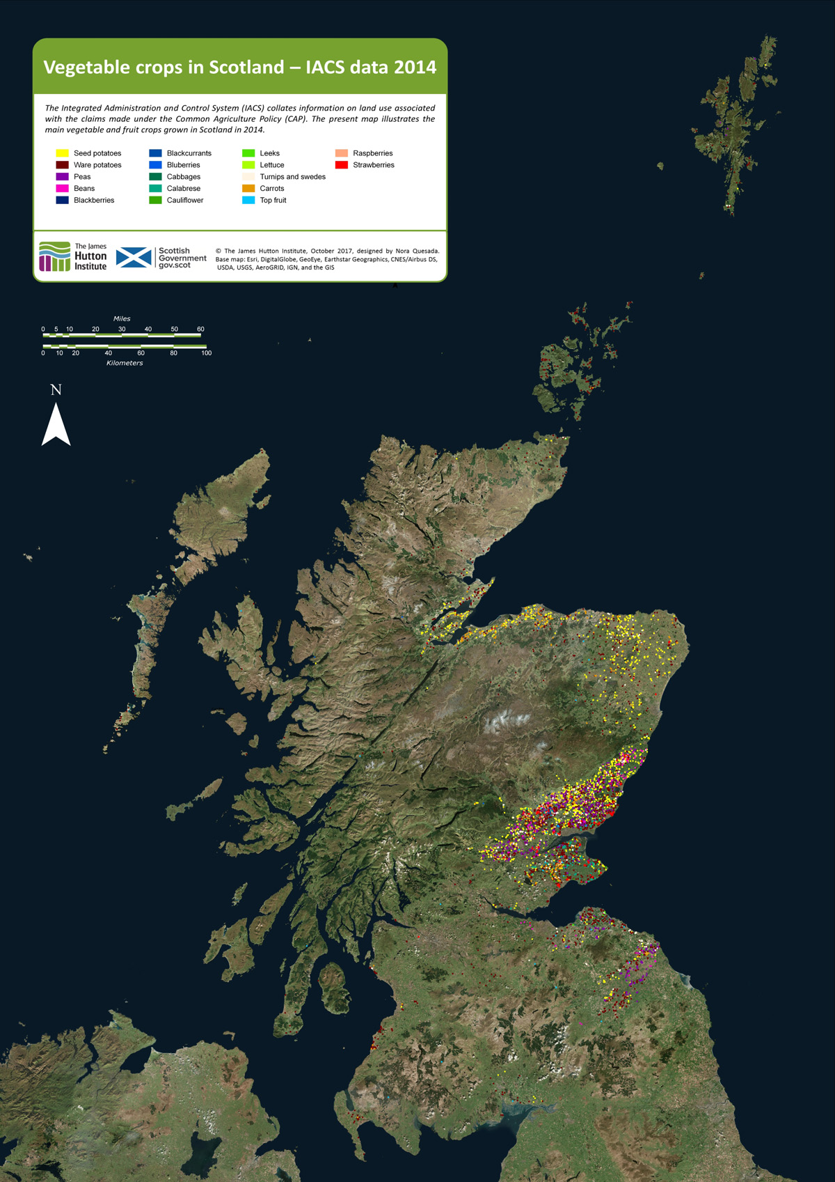
As background to the recent Vegetable Summit, held in Edinburgh, London and Cardiff, Nourish Scotland [1] asked the James Hutton Institute if it was possible to define the places where vegetables are grown in the region. The resulting map, prepared by Nora Quesada, is shown below.
Click on the map to open a larger version in a separate tab
Each coloured dot on the map indicates a field of fruit or vegetables. (The dots are much larger than individual fields.) It is clear from the distribution of dots that relatively little land exists in Scotland on which vegetables and fruit are grown. Even in places where the coloured dots are concentrated, the land area covered by fruit and vegetables is generally less than a few percent. Most of the other cultivated land is under cereals, wheat and barley.
Why do we want to know where vegetables are grown? Questions around diet, health and food poverty at this time of agricultural plenty were raised in a recent issue of Nourish Scotland’s magazine, January 2017, with the title ‘What would Boyd Orr do?’ [2].
John Boyd Orr was a pioneer of research into nutrition in Scotland many decades ago. His work became known throughout the world. The article asked what he would do today faced with the situation that, while vegetables are essential for a healthy human diet, most are imported and fail to reach the people that need them.
It is important to know therefore whether more land than shown on the maps can be converted to growing vegetables? For example, how much land would be needed to provide an optimum (rather than minimum) diet for the whole country from local produce; and can the cities be supplied with fruit and veg by the land surrounding them?
To answer such questions, it is necessary, first, to know what is grown and where. That is the purpose of the present mapping.
How is it done?
The EU’s Integrated Administration and Control Systems (IACS), which is used to manage farm subsidies, collects data on the crops grown on each field. The Scottish Government provided that information to the James Hutton Institute. Each field in IACS is geo-referenced and can be located on a base map that is of high enough resolution to show the outlines of the fields. The IACS reference then allows the fields on the base map to be linked to specific crops in specific years. This is how the maps shown in this article were constructed [3].
The IACS system does not account for vegetables from gardens and allotments and inner city and rural small scale production. There is much activity at these small scales, which we’ll look at in future posts.
Here we consider two examples of areas where vegetables are now produced: Strathmore and Angus and then Moray, Cromarty and Tarbat. Commercial growing needs good soil and a not-too-extreme climate, and given the difficulty of finding this combination in Scotland, it becomes apparent that today’s vegetable-producing regions have had strategic importance for hundreds and even thousands of years.
Strathmore and Angus
The main area for production of vegetables lies in Strathmore (map below), which stretches over a generally lowland region, from east of Perth and then in a north-east direction to the coast north of Angus. Angus itself is a major source of fruit and many types of vegetable. Across the Tay, parts of Fife are similarly productive.
The crops occupying the greatest surface area are still the cereals – barley and wheat – but they are not shown on the map. In addition to potato and a wide range of vegetables, this area is the centre of fruit growing in Scotland – strawberries, raspberries and blackcurrants.
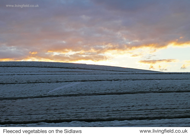
Increasingly in recent decades many vegetables are sown in the field then covered with a protective fleece to encourage early growth and to distance them from pests. Similarly, most soft fruit growing today is under the protection of polytunnels, where again the environment is less severe in winter and pests can be regulated.
Strathmore, Angus and Fife showing approx. locations of fields growing vegetables in one year.
The fertile soils and maritime climate here were of strategic importance to the iron age communities who built their many hill forts along the Sidlaw Hills that form a barrier between Strathmore and the estuary and coast to the south. The famous Dunsinane, or Dunsinnan as it is referred to on old local maps, is one of them [4]. One of the photographs shown below was taken from Dunsinnan, north across Strathmore.
Later the Romans invaded, moving north from the region of Hadrian’s Wall, not finding much of a welcome it seems, and erecting forts and watchtowers along the Gask Ridge and in a line just within but near the northern extremity of the cloud of coloured dots in the image above [5].
The Romans’ massive Legionary Fortress at Inchtuthil, within the northern boundary of the strath (see map above), was built and deserted in the 1st Century AD, and was probably sited to guard the passes north along what is today’s A9. The fortress and marching soldiers would have needed constant supplies of food, and probably achieved this by access to the rich land of Strathmore.
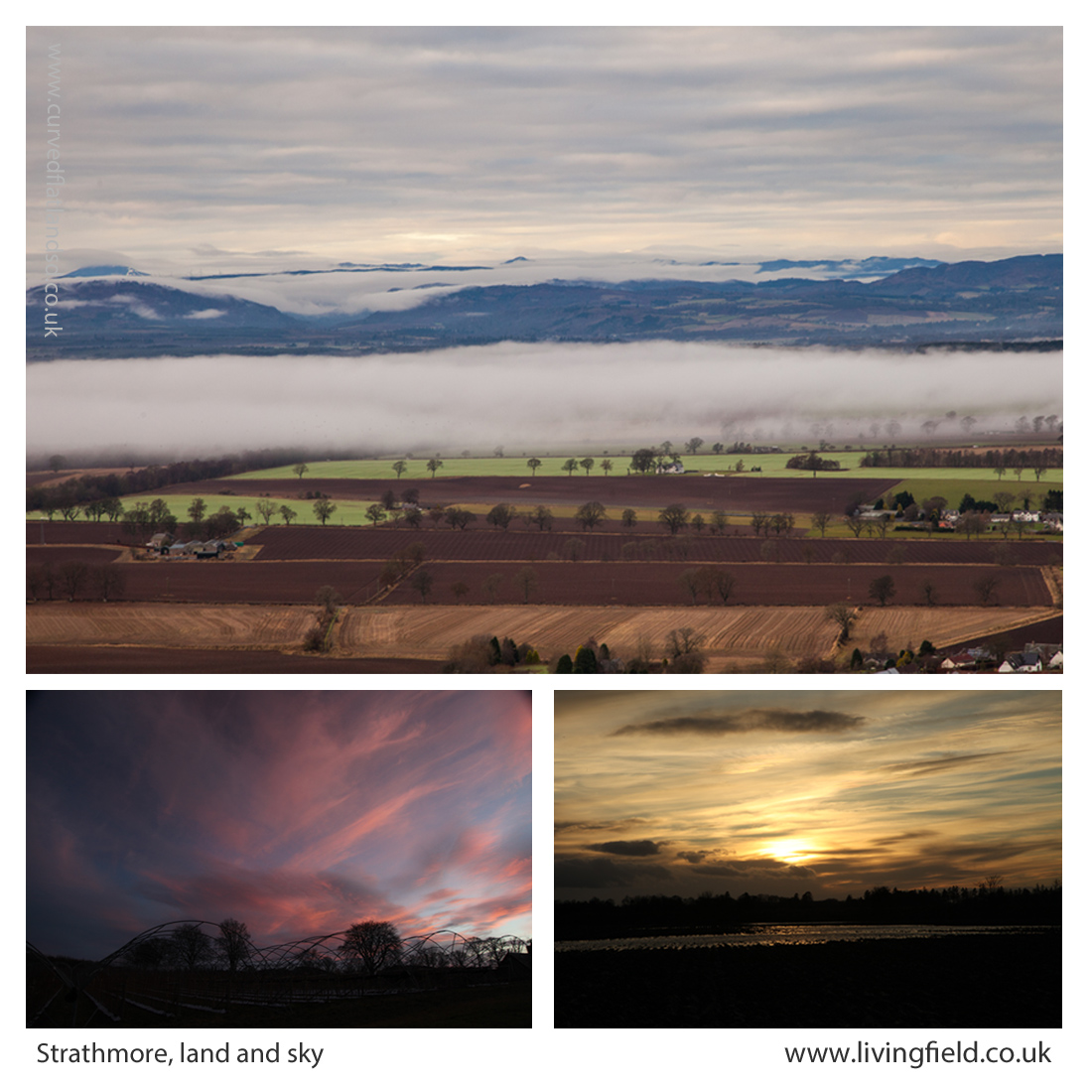
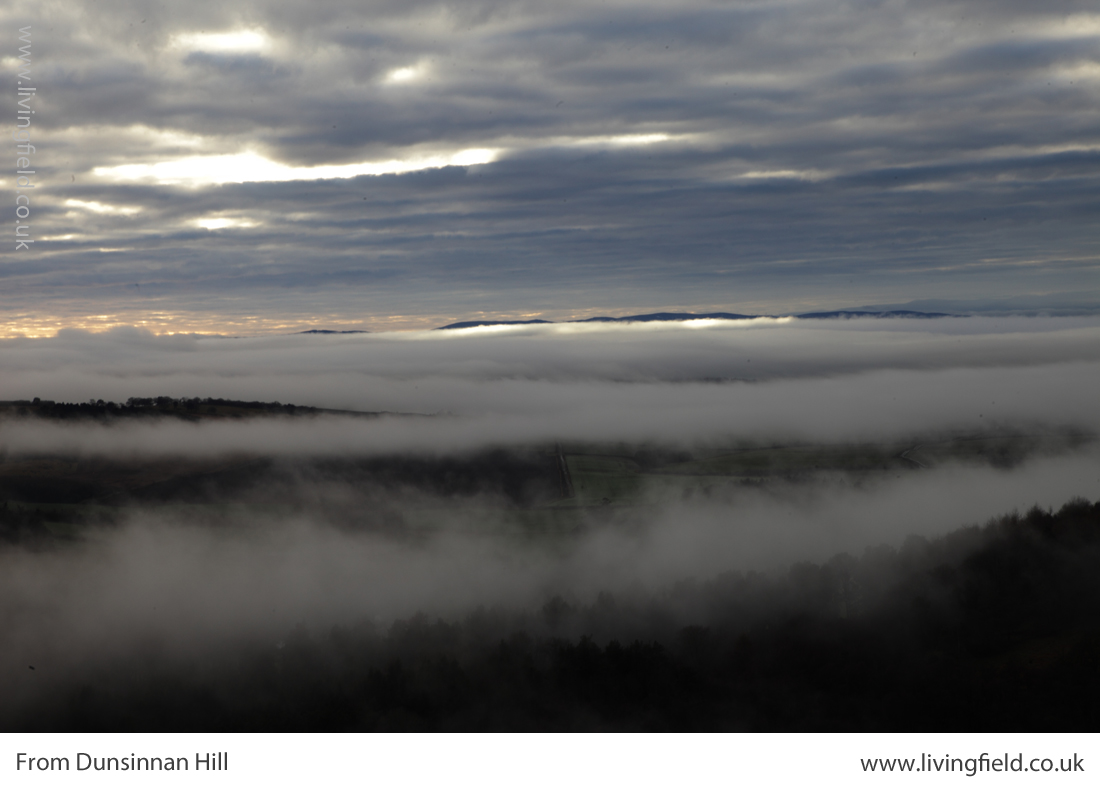
From Dunsinnan Hill north across Strathmore (top), the Isla in flood at the the last sunset of the year (lower r) and winter sky above polytunnel frames (www.livingfield.co.uk)
The image at the top of the three above was taken from Dunsinnan early in year, looking across Strathmore. The nearest fields are still in stubble after last year’s harvest; the intermediate ones, showing rich brown soil, have been ploughed; and the green ones just beneath the low cloud were sown the previous autumn with winter cereals or oilseeds. The Roman line stretched this side of the hills.
Centuries later, the Picts made this productive region integral to their southern kingdom in the 7th and 8th centuries. Many symbol stones and ‘pit- ‘ place names survive here from that time [6]. Some of the crops grown here today would not be known then – potato, for example, was yet to cross the Atlantic, and the other ‘root’ crops – turnip and swede – were probably unknown.
Yet Strathmore, Angus and Fife would have offered enough agricultural land to feed this civilisation with its basic grain and protein. You can see it was a prize that other peoples would want to take for their own – the Scots moving across from Ireland would have found little land of comparable quality on the west coast.
The Black Isle, Moray, Tarbat, Cromarty
A hundred miles directly north of Inchtuthil Fortress, across today’s passes of Drumochter and Slochd, the land falls to the coast and becomes productive again. The area (map below) grows fewer types of vegetable today than Strathmore, but grain and tuber yields remain high.
The coloured dots show that seed and ware potato were the commonest vegetables in this region, but interestingly carrot is also prevalent. Go back to the 1780s and the farmer/traveller Andrew Wight had this to relate when riding along the northern side of the Cromarty Firth [7]:
“….. that Robert Hall, the farm manager of Fowlis ‘introduced a crop, rare in Scotland and an absolute novelty in the north, which is carrot. ….. The farm-horses are fed on carrots instead of corn; and they are always in good condition.”
Andrew Wight visited the area as part of his survey of the Improvements in the late 1700s, but the rich coastal land here has a historical legacy stretching back centuries.
The map above shows the area around the Cromarty and Moray Firths, the Moray coast stretching to the right and the Black Isle left of centre.
The northern Picts established their ‘elite’ farm and monastery at Portmahomack on the northern tip of the Tarbat peninsula. Their massive carved stones, at Nigg, Cadboll and Shandwick, were major contributions to European art. They arose within a civilisation based on the stability afforded by this good agricultural land [6].
As for Strathmore, the rich soil around the Dornoch and Cromarty Firths must have been eyed by the Scots from the west and the Norse from the east. Pictish civilisation, with its distinctive art and craft, did not survive.
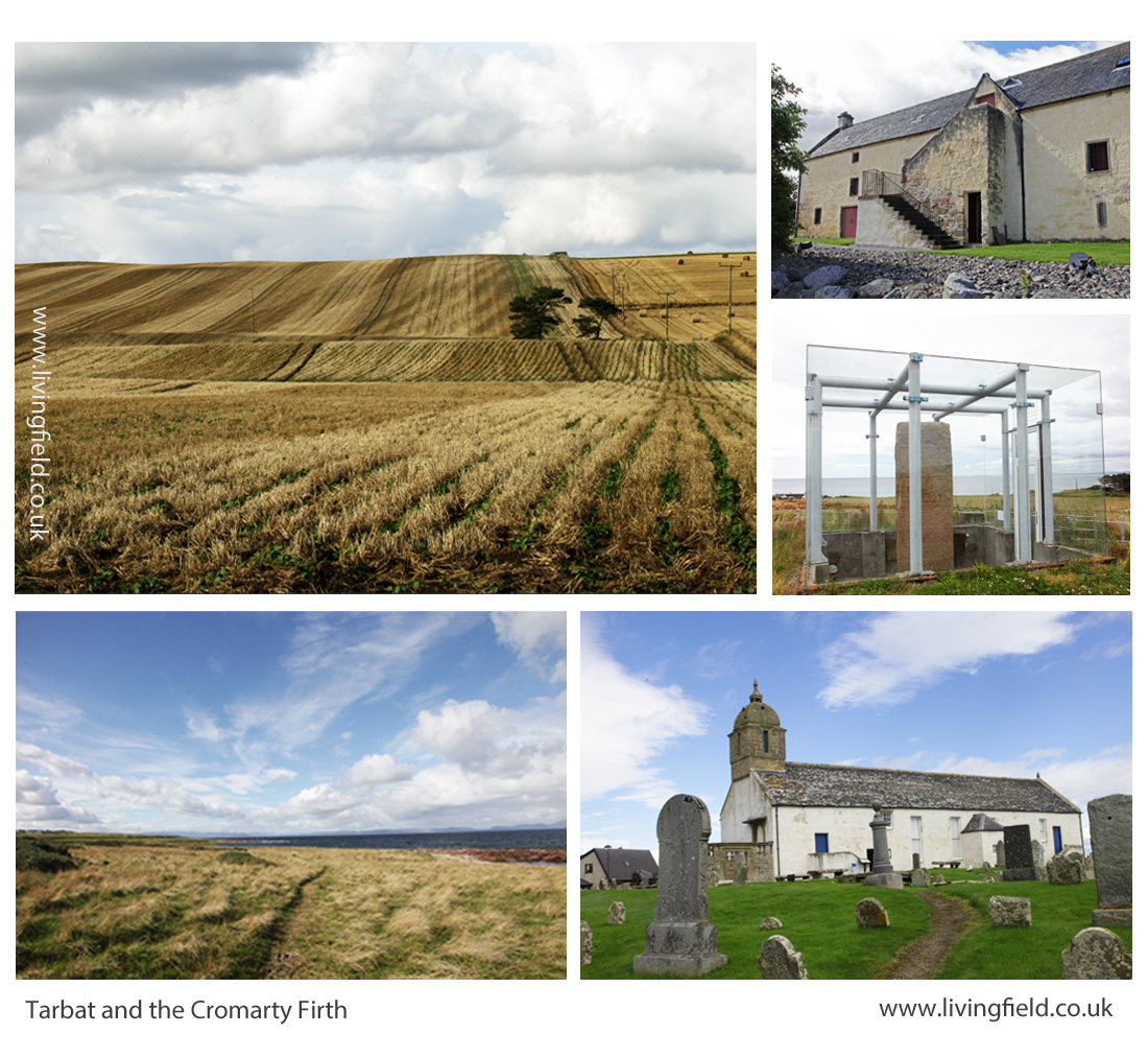
Lines in the earth, Tarbat, including rapeseed drilled directly into cereal stubble (top left), then clockwise, the Storehouse of Foulis built in the 1700s; the Picts’ Shandwick Stone; site of the Tarbat Discovery Centre; and coastal grazing looking from Tarbat across the Dornoch Firth (www.livingfield.co.uk)
Opportunities
The maps derived from IACS data show the extent of vegetable growing today. Vegetables and fruit could be grown over a much wider area and a much higher density if the demand was there.
For example, the pulses – beans and peas – plants that fix their own nitrogen and so save on mineral fertiliser, have been reduced to a minor crop. The IACS map shows concentrations of peas and beans in the Borders, but overall the pulses cover less than 5% of the arable land. This is low by global standards. Countries that have transformed their agriculture in recent years now assign a quarter of their land to nitrogen-fixing crops.
Developments towards greater veg and fruit production and nitrogen fixing pulses will not be just though existing growers expanding their production. There are many local initiatives, some in areas considered inhospitable for vegetables. There is great scope therefore for increasing production but the demand for quality local produce has to be there from consumers.
Future posts on this web site will look at the value of fruit and veg to health, the degree to which Scotland depends (and it depends a lot) on imports for its fruit and veg, the new vegetable products that are appearing on the market (including beer and bread from beans), the increasing local initiatives in veg production and the possibilities for growing much more fruit and veg and making it available to those who need it.
For more on vegetables on the Living Field web site…
Next up –Veg at Bangkok markets, Thailand and Minerals and vitamins from vegetables and fruit.
From Dunsinnan, across Strathmore, early in the year 2017
Sources, links
[1] Nourish Scotland: The Vegetable Summit was held on 24 October 2017. For background see Peas Please – the Veg Project.
[2] What would Boyd Orr do? Nourish Scotland Magazine, Issue 6, January 2017. The link is to a pdf file. The article by Pete Ritchie explains John Boyd Orr’s contribution and his continuing relevance today. Other articles cover diet, food poverty, vegetables and right to food.
[3] IACS and map construction. Information of the Integrated Administration and Control System IACS scheme can be found at the web pages of the European Commission and the Scottish Government. Examples of a major exercise in mapping based on IACS data are given in a CAP Greening Review carried out by the James Hutton Institute for Scottish Government, published 2017: for links to the multi-part documentation, see CAP Greening Review on the SG web site; the section on mapping is Part 3 – Maps by David Miller, Doug Wardell-Johnson and Keith Matthews. Maps of vegetable growing produced in the present article were prepared by Nora Quesada.
[4] Dunsinnan hill fort. The Canmore site gives a detailed description. A string of Iron Age ‘forts’ along the Sidlaw Hills south of Strathmore and just north of the flat, reclaimed coastal plain of the Carse of Gowrie, can be seen on the OS map of the area. Search for hill ‘forts’ by name. (Ps. Shakespeare promoted a different pronunciation – Dunsinane.)
[5] The exhibition Roman Empire – Power and People in 2015 at the McManus in Dundee was an invaluable introduction to life at the northern limits of the Roman Empire. The LF article Feeding the Romansgives some background on the land use around the line of fortifications along Strathmore. For comprehensive coverage of this northern Roman frontier: Woolliscroft, DJ, Hoffmann, B 2006. Rome’s first frontier – the Flavian occupation of Northern Scotland. The History Press (reprinted 2011).
[6] Carver, Martin (2016) Portmahomack: Monastery of the Picts. Edinburgh University Press. (2nd edition). Excavations of the farm and monastery are described. The Picts, flourishing between the 600s and 900s were part of a wider European culture . In their travels, they most likely imported various plants for use as food and medicinals, yet very little other than remnants of grain have survived. Maps in the book show the location of pit- place names.
[7] For Andrew Wight’s note on the innovative growing of carrots by the Cromarty Firth in the 1780s, see Great Quantities of Aquavitae II on this web site.