Peas and beans, and other grain legumes, have been on the decline for many decades. Archaeological records show their place in Scottish agriculture since early farming in the neolithic age. They were common once – and considered essential by some innovators such as the early Monastic farmers.
They had dual benefits – offering higher plant protein than cereal crops and enriching soil by fixing nitrogen from the air into their roots, and when the roots died the nitrogen went into the soil for next year’s crop. Despite the benefits, their growing in Scotland declined over time to a point in the 1930s where they had become rare as field crops..
Peas and beans have in recent times shown some signs of recovery as their benefits were rediscovered, especially since crop sequences that include legumes need less mineral fertiliser and hence contribute less to GHG emissions.
But it’s their value as food, in the form of peasemeal flatbreads and similar delights, that was told in a recent article by Pete Iannetta of the James Hutton Institute (reference to be added). So, as some further background, this note gives reference to peas and beans in crop rotations found in written sources from the 1400s to around a century ago.
Monastic enforcement
Many agricultural innovations were introduced in the centuries following the spread northwards of Christian religious houses from their base in France and southern England [1]. The monks’ stipulations, as related in Franklin’s (1952) account [2] of the Act of 1457 and later, read like a recipe for regenerative farming today – planting trees, hedges and broom parks, sowing crops such as wheat, peas, rye and beans in rotation (Act of 1472), and removing noxious weeds like corn marigold [3].
Franklin [2] states that – while the Acts were ‘almost universally disregarded’ – the Monks of Coupar inserted in their leases to farming tenants ‘a clause which ran roughly as follows’:
“And the said — shall put the land to every improvement in his power in building and fencing and planting trees, that is ashes, osiers, birch, willow and broom, with hawthorn fences and protection for them. And he shall keep his land free from corn marigold, and shall keep the acts of parliament in sowing wheat, peas, rye and beans, and shall labour for the gaining of the marsh.”
The gaining of the marsh presumably refers to wet boggy land generally, but more specifically to the Carse of Gowrie (south of Coupar and between the Sidlaw Hills and the Tay estuary), which as a result of that drainage and subsequent maintenance became one of the most productive agricultural areas in Scotland [4]. And it is also notable that the leguminous broom, and in other sources the leguminous even if spinous gorse, were cultivated as fodder crops, a practice that continued to within the last 100 years.
[2] Franklin, T Bedford (1852) A history of Scottish Farming. Thomas Nelson and Sons Ltd, Edinburgh (and London, Melbourne, Cape Town, Toronto, and New York).
[3] The corn marigold or gool(e), now a rare plant of cropland, was once considered a noxious weed, the toleration of which was considered a crime: link to the Living Field article – Gool rider, Gool rider.
Three flours that sustained life on the Atlantic seaboard for centuries. Commonly grown as a crop mixture in the field. Mixed and cooked into tasty bannocks in the kitchen. Decline to near extinction in the 20th century. Now with a great future as sustainable low-input crops, bringing diversity to the farmed landscape and healthy, nutritious food.
Peas, bere (barley) and oats have been a staple plant mixture giving protein and carbohydrate through the centuries of farming on the Atlantic seaboard. Yet in Scotland, as in much of Atlantic Europe, their role diminished within living memory.
Peas declined in area from the mid 1800s to to almost nothing in the 1930s. Bere dropped out of census records in the 1880s but was then nearly lost except in a few northern fields. Oat fell from being the dominant grain crop over the last few hundred years to covering less area than barley and wheat by 1950 [1]. Their decline is now being reversed.
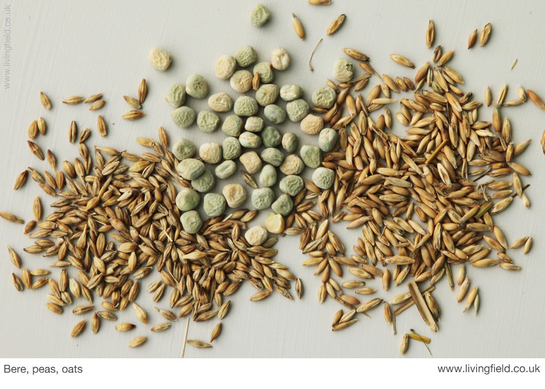
Bere grain (left), marrowfat peas and oat grain (right): bear and oat grown in the Living Field garden, peas from a packet (www.livingfield.co.uk).
Peas as crops and food
Traditionally peas along with bere and oats, and sometimes beans, was the staple protein food of the rural working population in Scotland. They were the local pulse and grain – the sustaining combination of plants that once fed the world and still feeds large parts of it.
Fenton’s Food of the Scots [2] cites many records from the 1400s to the late 1800s of peas, beans and cereal grains grown alone or in mixtures. Similarly, the flours of peas, oats and bere were eaten as bread and bannocks, either as sole constituents or baked in combination.
The pulse crops were certainly recognised and widely appreciated here for hundreds of years. A 1426 Act of Parliament in Scotland stipulated that a farmer should sow 1/12 of his labour in peas [2], not just for protein food but to fertilise the soil with nitrogen (though the process of biological nitrogen fixation by legumes was not understood until many centuries later).
The products of peas and beans were grown locally, traded across the country or imported by sea, often from nearby Atlantic and Baltic ports. Though peasemeal was demeaned as a food of the labouring classes in some regions, the inclusion of peas in the subsistence diet was recommended by Hutchison in 1869 [2] as contributing to a healthier and longer life for the rural worker and their family.
Decline of peas
The records cited by Fenton indicate peas as a crop and food were more important here than beans Vicia faba. Yet by the mid-1800s, that order was reversed. At the first crop census in 1854, beans occupied 6 times more area than peas [1]. The cause of the decline of peas as a crop is suggested by MacDonald (1908) as due to ‘the extended use of potato’ in the subsistence economy [2] and by Porter (1925) to the replacement of pulses by clover and grass mixtures [3] that are better at maintaining soil fertility.
Well into the period up to the 1950s, both pulses were named individually in the census and classed as grain crops to be harvested like cereals, yet unlike the cereal grains, they continued to decline in area despite a short-lived revival in the late 1940s (when food imports and nitrogen fertiliser wererestricted).
Peas became a minor crop by the 1930s and disappeared from the annual census in the 1950s. Beans went a decade or so later. They covered too small an area to be recorded in the annual summary. They reappeared gradually from the 1960s in different forms, such as ‘vining peas’ for human consumption, but that’s another story, and despite a rise in sown area similar to that of the 1880s, peas and beans together now cover 1-2% of the cropped surface, a very low percentage.
The benefits of all three products – peasemeal, beremeal and oatmeal – to health and environment are increasingly recognised today. Here, we wonder what peasemeal-beremeal-oatmeal bannocks tasted like and decided to find out.
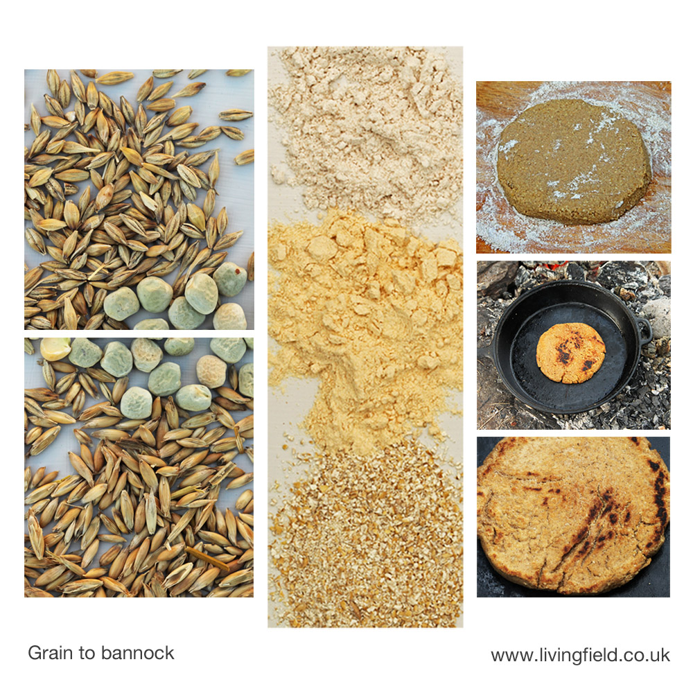
Grain – top bere, middle peas, lower oats – is ground to beremeal, peasemeal and oatmeal, which are mixed with water, pressed on dry meal into a round, 1 cm thick, and heated in a pan until the bannock is cooked golden brown.
Peasemeal-beremeal-oatmeal bannocks
For much of recorded history in these islands, wheat was not as widely grown as oats and barley, and when it was grown or imported, it was more to feed the wealthy. Beremeal and oatmeal do not ‘rise’ much by themselves, so were most commonly eaten as bannocks, a form of flatbread [2]. The flours were mixed with water, patted into a round, typically 1 to 2 cm thick, and baked on a hot surface on or by a fire.
To try out the method, flours were sourced from water-powered mills at Golspie in Sutherland and Birsay on Orkney [4]. Then trial and error – peasemeal and oatmeal, peasemeal and beremeal and all three together, the latter preferred for the blend of tastes.
The oatmeal was medium-ground and gave some granularity to the mix. The peasemeal had a yellowish colour, while the beremeal was more of a light brown than a standard refined wheat flour. On the packets, peasemeal had a protein content of 20.4% and oatmeal (as most unrefined cereals) around 13%.
The three were placed in a bowl at about 1:1:1, or slightly more oatmeal than each of the other two, mixed into a thick paste or dough with water, turned out onto the board with a little beremeal on it to stop it sticking and then pressed into a bannock (about 10 -15 cm wide and 1 cm thick).
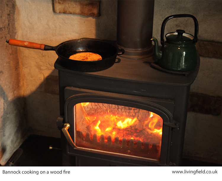
It took 10 to 15 minutes to cook the bannock slowly in a cast iron pan, very lightly oiled with cold-pressed rapeseed, though oiling is not essential. Heat sources tried were a modern gas stove, an indoor wood stove and an outdoor fire.
The three-meal bannock was tasty and filling, eaten with butter or marge (could try a drizzle of oil), marmite, various cheeses and dipped in soup. A satisfying experience.
Yield and environmental benefit
Pea Pisum sativum is now grown in various forms, for animal feed, for canning and freezing to feed people and as a fresh vegetable. The peas traditionally used for peasemeal or flour tended to be marrowfat or similar types, harvested when mature [but see note 4]. Peas need no nitrogen fertiliser and less pesticide than most non-legume crops.
Bere, the traditional landrace of barley Hordeum vulgare, is now grown only in a few localities, but appears to need less fertiliser and pesticide than modern two row barleys. Oats Avena sativa were overtaken by barley in the middle to the 1900s as the Scottish cereal crop of choice, but they too need less pesticide and fertiliser than barley and recently oat yields have increased to rival those of spring barley. Oat is also nutritionally superior to barleys and wheats.
Many records over recent centuries describe the growing of two or three crops mixed together in one field. ‘Mixed grains’ was recorded in the crop census for most of the 1900s, while mashlum – a mix of peas or beans with oat or barley – was common enough to be cited as a distinct crop category from 1944 to 1978 [5]. As related elsewhere on the Living Field web site (see Mashlum – a traditional mix of oats and beans) these crop mixtures disappeared from the census records but are still grown by a few farmers who value their contribution to fertility and nutrition.
The yields, nutritional content and environmental benefit of traditional landraces and mixed grains are being researched and quantified at the James Hutton Institute, Dundee [6, 7}.
Teaching about grains, milling, flour and food at Open Days
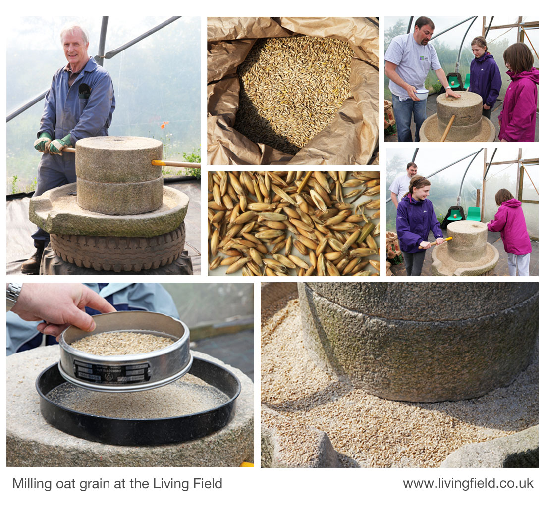
The Living Field bought its own hand-powered corn mill a few years ago. It consist of a stone base and two grinding stones. The latter were honed by Mr Roberts from the Hutton’s workshop and the whole was supported by old tyres. Grain (in this case oats, centre top) is fed into a vertical channel in the upper stone and falls down through to the gap between the stones.
The stones are turned by the wooden rod, as shown by Mr Young and two visitors at an Open Day (this one in 2012). The grain is ground between the stones to a mix of meal and bran (the husks of the grain) which gets pushed out and collects in the stone base from where it is brushed off into a container (lower right). The meal and bran are separated by hand using a sieve (lower left).
At Living Field open days – at Open Farm Sunday for instance – visitors can see the whole process from growing the plants from seed, harvesting grain, grinding the grain and separating the meal from the chaff. Gill Banks shows how to make bread from the flour made from these ancient varieties.
Sources, references, links
[1] Census records for the main crops began in 1854, then continued from the early 1880s through to 1978 as Agricultural Statistics Scotland, a fine source of information. Yearbooks are available online from the Scottish Government web site at Historical Agricultural Statistics. More on the 1854 census on the LF site at Thorburn’s diagrams and Bere country.
[2] Fenton A. 2007. The Food of the Scots. Volume 5 in A Compendium of Scottish Ethnology. Edinburgh: John Donald. Peas, peasemeal and bannocks appear in Ch 17 Bread and Ch 14 Field crops. Fenton cites: MacDonald J (1908) Editor of Stephens’ Book of the Farm for the loss of peas in preference to potato; and Hutchison R (1869) Report on the dietaries of Scotch agricultural labourers, (Transactions of the Highland and Agricultural Society, 4th, 2, 1-29).
[3] Porter J. 1925. The pea crop. In: Farm Crops, Ed. Paterson WG, The Gresham Publishing Company, London.
[4] Sources of the meal. Golspie Mill in Sutherland makes a range of flours and meals including the peasemeal ‘made from roasted yellow field peas’ and the oatmeal used here. Barony Mills at Birsay, Orkney makes the beremeal. Barony have appeared many times on this web site e.g. at Landrace 1 – bere. Suppliers who stock these products include Highland Wholefoods in Inverness.
[5] The Living Field is publishing, in 2018, articles, notes and photographs on crop mixtures as part of its Crop diversification series. The first post is Mashlum -a traditional mix of beans and oats (though mashlum can be any combination of pulses and grains).
[6] The James Hutton Institute carries out a wide range of studies on pulses and grains. The nutritional and environmental properties of pulses and pulse-grain mixed crops are examined in the EU H2020 TRUE project, coordinated from the Hutton Institute and with many partners across Europe. For further info, see TRUE Project EU and articles on the curvedflatlands web site at Transitions to a legume-based food and agriculture. Contact at the Institute: pete.iannetta@hutton.ac.uk.
Links to related articles on the Living Field web site
The page on the Bere line (rhymes with hairline) gives links to comments, images and articles on bere barley, including our correspondent Grannie Kate‘s recipes and experiences using bere meal and our Gill and Co’s breadmaking with various ingredients at Bere and cricket.
Can we grow more vegetables? looks at the current geographical distribution and status of vegetable growing in Scotland, including areas with peas and beans. Other links to pulses include: Scofu – the quest for an indigenous Scottish tofu and Feel the pulse – our travelling exhibit on peas, beans and their products,
The Living Field web site Editor, normally averse to the alchemy and incantations of cooking (best left alone!) managed to make (and eat) bannocks from the constituents bought from the sources indicated at [4]. Peasemeal brose is even easier – just add hot water to a couple of teaspoonfuls of peasemeal, stir and eat with toast or dips. Caution – beware the three-meal bannocks are addictive. Reconnecting with primordial tastes?
Vegetables and fruit in Scotland mapped. Regions of historically strategic land and soil. The Iron Age, then the Romans, Picts and 1700s Improvers. Imports vs local production. Opportunities.
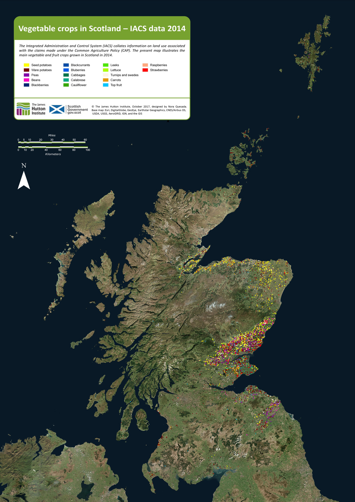
As background to the recent Vegetable Summit, held in Edinburgh, London and Cardiff, Nourish Scotland [1] asked the James Hutton Institute if it was possible to define the places where vegetables are grown in the region. The resulting map, prepared by Nora Quesada, is shown below.
Click on the map to open a larger version in a separate tab
Each coloured dot on the map indicates a field of fruit or vegetables. (The dots are much larger than individual fields.) It is clear from the distribution of dots that relatively little land exists in Scotland on which vegetables and fruit are grown. Even in places where the coloured dots are concentrated, the land area covered by fruit and vegetables is generally less than a few percent. Most of the other cultivated land is under cereals, wheat and barley.
Why do we want to know where vegetables are grown? Questions around diet, health and food poverty at this time of agricultural plenty were raised in a recent issue of Nourish Scotland’s magazine, January 2017, with the title ‘What would Boyd Orr do?’ [2].
John Boyd Orr was a pioneer of research into nutrition in Scotland many decades ago. His work became known throughout the world. The article asked what he would do today faced with the situation that, while vegetables are essential for a healthy human diet, most are imported and fail to reach the people that need them.
It is important to know therefore whether more land than shown on the maps can be converted to growing vegetables? For example, how much land would be needed to provide an optimum (rather than minimum) diet for the whole country from local produce; and can the cities be supplied with fruit and veg by the land surrounding them?
To answer such questions, it is necessary, first, to know what is grown and where. That is the purpose of the present mapping.
How is it done?
The EU’s Integrated Administration and Control Systems (IACS), which is used to manage farm subsidies, collects data on the crops grown on each field. The Scottish Government provided that information to the James Hutton Institute. Each field in IACS is geo-referenced and can be located on a base map that is of high enough resolution to show the outlines of the fields. The IACS reference then allows the fields on the base map to be linked to specific crops in specific years. This is how the maps shown in this article were constructed [3].
The IACS system does not account for vegetables from gardens and allotments and inner city and rural small scale production. There is much activity at these small scales, which we’ll look at in future posts.
Here we consider two examples of areas where vegetables are now produced: Strathmore and Angus and then Moray, Cromarty and Tarbat. Commercial growing needs good soil and a not-too-extreme climate, and given the difficulty of finding this combination in Scotland, it becomes apparent that today’s vegetable-producing regions have had strategic importance for hundreds and even thousands of years.
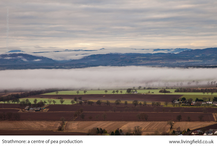
Strathmore and Angus
The main area for production of vegetables lies in Strathmore (map below), which stretches over a generally lowland region, from east of Perth and then in a north-east direction to the coast north of Angus. Angus itself is a major source of fruit and many types of vegetable. Across the Tay, parts of Fife are similarly productive.
The crops occupying the greatest surface area are still the cereals – barley and wheat – but they are not shown on the map. In addition to potato and a wide range of vegetables, this area is the centre of fruit growing in Scotland – strawberries, raspberries and blackcurrants.
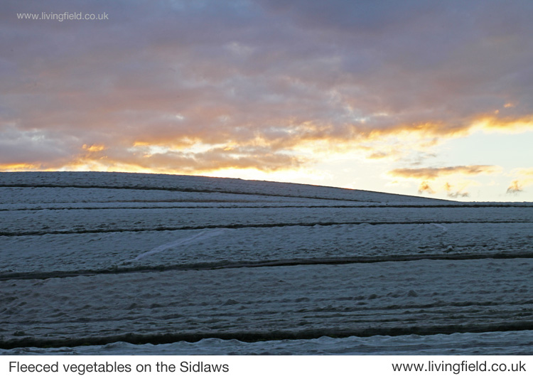
Increasingly in recent decades many vegetables are sown in the field then covered with a protective fleece to encourage early growth and to distance them from pests. Similarly, most soft fruit growing today is under the protection of polytunnels, where again the environment is less severe in winter and pests can be regulated.
Strathmore, Angus and Fife showing approx. locations of fields growing vegetables in one year.
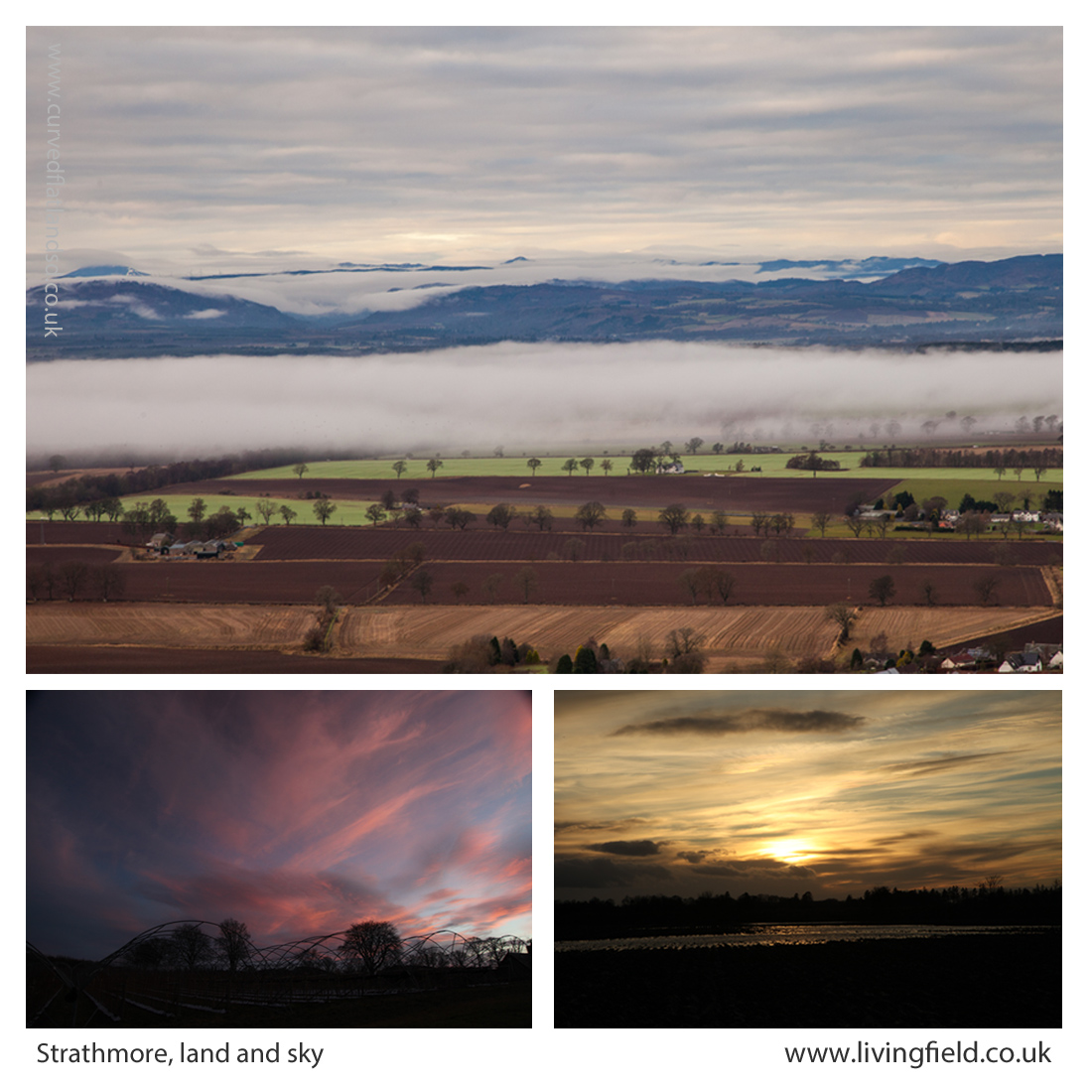
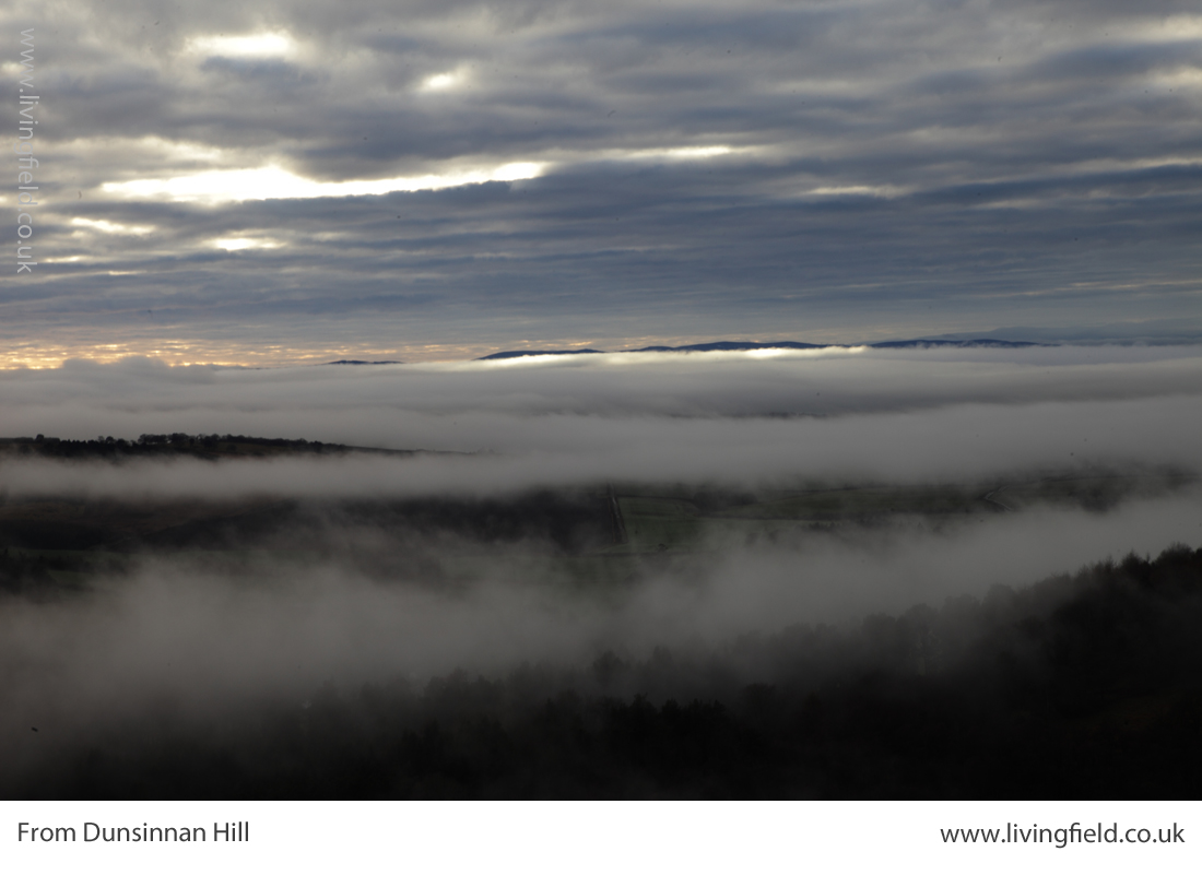
The fertile soils and maritime climate here were of strategic importance to the iron age communities who built their many hill forts along the Sidlaw Hills that form a barrier between Strathmore and the estuary and coast to the south. The famous Dunsinane, or Dunsinnan as it is referred to on old local maps, is one of them [4]. One of the photographs shown below was taken from Dunsinnan, north across Strathmore.
Later the Romans invaded, moving north from the region of Hadrian’s Wall, not finding much of a welcome it seems, and erecting forts and watchtowers along the Gask Ridge and in a line just within but near the northern extremity of the cloud of coloured dots in the image above [5].
The Romans’ massive Legionary Fortress at Inchtuthil, within the northern boundary of the strath (see map above), was built and deserted in the 1st Century AD, and was probably sited to guard the passes north along what is today’s A9. The fortress and marching soldiers would have needed constant supplies of food, and probably achieved this by access to the rich land of Strathmore.
From Dunsinnan Hill north across Strathmore (top), the Isla in flood at the the last sunset of the year (lower r) and winter sky above polytunnel frames (www.livingfield.co.uk)
The image at the top of the three above was taken from Dunsinnan early in year, looking across Strathmore. The nearest fields are still in stubble after last year’s harvest; the intermediate ones, showing rich brown soil, have been ploughed; and the green ones just beneath the low cloud were sown the previous autumn with winter cereals or oilseeds. The Roman line stretched this side of the hills.
Centuries later, the Picts made this productive region integral to their southern kingdom in the 7th and 8th centuries. Many symbol stones and ‘pit- ‘ place names survive here from that time [6]. Some of the crops grown here today would not be known then – potato, for example, was yet to cross the Atlantic, and the other ‘root’ crops – turnip and swede – were probably unknown.
Yet Strathmore, Angus and Fife would have offered enough agricultural land to feed this civilisation with its basic grain and protein. You can see it was a prize that other peoples would want to take for their own – the Scots moving across from Ireland would have found little land of comparable quality on the west coast.
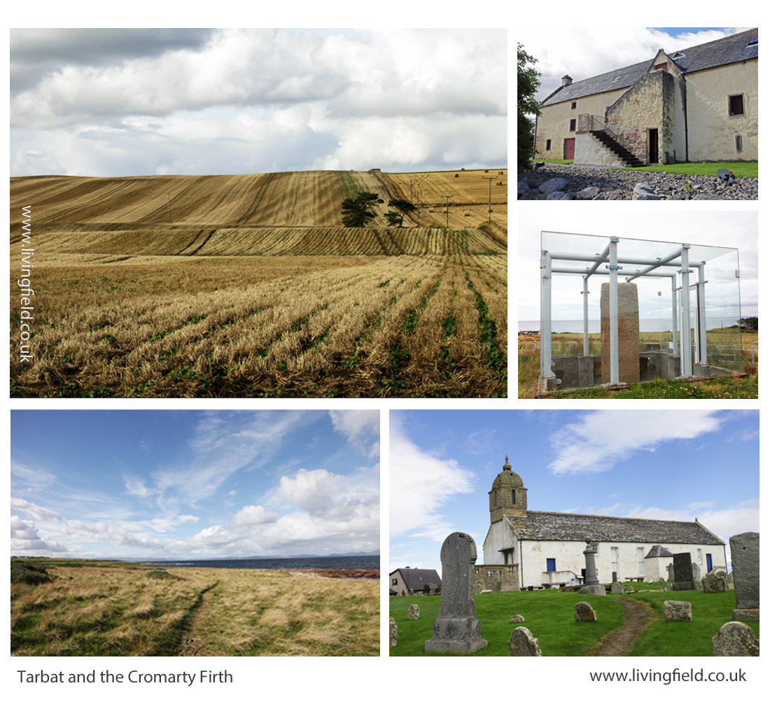
The Black Isle, Moray, Tarbat, Cromarty
A hundred miles directly north of Inchtuthil Fortress, across today’s passes of Drumochter and Slochd, the land falls to the coast and becomes productive again. The area (map below) grows fewer types of vegetable today than Strathmore, but grain and tuber yields remain high.
The coloured dots show that seed and ware potato were the commonest vegetables in this region, but interestingly carrot is also prevalent. Go back to the 1780s and the farmer/traveller Andrew Wight had this to relate when riding along the northern side of the Cromarty Firth [7]:
“….. that Robert Hall, the farm manager of Fowlis ‘introduced a crop, rare in Scotland and an absolute novelty in the north, which is carrot. ….. The farm-horses are fed on carrots instead of corn; and they are always in good condition.”
Andrew Wight visited the area as part of his survey of the Improvements in the late 1700s, but the rich coastal land here has a historical legacy stretching back centuries.
The map above shows the area around the Cromarty and Moray Firths, the Moray coast stretching to the right and the Black Isle left of centre.
The northern Picts established their ‘elite’ farm and monastery at Portmahomack on the northern tip of the Tarbat peninsula. Their massive carved stones, at Nigg, Cadboll and Shandwick, were major contributions to European art. They arose within a civilisation based on the stability afforded by this good agricultural land [6].
As for Strathmore, the rich soil around the Dornoch and Cromarty Firths must have been eyed by the Scots from the west and the Norse from the east. Pictish civilisation, with its distinctive art and craft, did not survive.
Lines in the earth, Tarbat, including rapeseed drilled directly into cereal stubble (top left), then clockwise, the Storehouse of Foulis built in the 1700s; the Picts’ Shandwick Stone; site of the Tarbat Discovery Centre; and coastal grazing looking from Tarbat across the Dornoch Firth (www.livingfield.co.uk)
Opportunities
The maps derived from IACS data show the extent of vegetable growing today. Vegetables and fruit could be grown over a much wider area and a much higher density if the demand was there.
For example, the pulses – beans and peas – plants that fix their own nitrogen and so save on mineral fertiliser, have been reduced to a minor crop. The IACS map shows concentrations of peas and beans in the Borders, but overall the pulses cover less than 5% of the arable land. This is low by global standards. Countries that have transformed their agriculture in recent years now assign a quarter of their land to nitrogen-fixing crops.
Developments towards greater veg and fruit production and nitrogen fixing pulses will not be just though existing growers expanding their production. There are many local initiatives, some in areas considered inhospitable for vegetables. There is great scope therefore for increasing production but the demand for quality local produce has to be there from consumers.
Future posts on this web site will look at the value of fruit and veg to health, the degree to which Scotland depends (and it depends a lot) on imports for its fruit and veg, the new vegetable products that are appearing on the market (including beer and bread from beans), the increasing local initiatives in veg production and the possibilities for growing much more fruit and veg and making it available to those who need it.
For more on vegetables on the Living Field web site…
Next up –Veg at Bangkok markets, Thailand and Minerals and vitamins from vegetables and fruit.
From Dunsinnan, across Strathmore, early in the year 2017
Sources, links
[1] Nourish Scotland: The Vegetable Summit was held on 24 October 2017. For background see Peas Please – the Veg Project.
[2] What would Boyd Orr do? Nourish Scotland Magazine, Issue 6, January 2017. The link is to a pdf file. The article by Pete Ritchie explains John Boyd Orr’s contribution and his continuing relevance today. Other articles cover diet, food poverty, vegetables and right to food.
[3] IACS and map construction. Information of the Integrated Administration and Control System IACS scheme can be found at the web pages of the European Commission and the Scottish Government. Examples of a major exercise in mapping based on IACS data are given in a CAP Greening Review carried out by the James Hutton Institute for Scottish Government, published 2017: for links to the multi-part documentation, see CAP Greening Review on the SG web site; the section on mapping is Part 3 – Maps by David Miller, Doug Wardell-Johnson and Keith Matthews. Maps of vegetable growing produced in the present article were prepared by Nora Quesada.
[4] Dunsinnan hill fort. The Canmore site gives a detailed description. A string of Iron Age ‘forts’ along the Sidlaw Hills south of Strathmore and just north of the flat, reclaimed coastal plain of the Carse of Gowrie, can be seen on the OS map of the area. Search for hill ‘forts’ by name. (Ps. Shakespeare promoted a different pronunciation – Dunsinane.)
[5] The exhibition Roman Empire – Power and People in 2015 at the McManus in Dundee was an invaluable introduction to life at the northern limits of the Roman Empire. The LF article Feeding the Romansgives some background on the land use around the line of fortifications along Strathmore. For comprehensive coverage of this northern Roman frontier: Woolliscroft, DJ, Hoffmann, B 2006. Rome’s first frontier – the Flavian occupation of Northern Scotland. The History Press (reprinted 2011).
[6] Carver, Martin (2016) Portmahomack: Monastery of the Picts. Edinburgh University Press. (2nd edition). Excavations of the farm and monastery are described. The Picts, flourishing between the 600s and 900s were part of a wider European culture . In their travels, they most likely imported various plants for use as food and medicinals, yet very little other than remnants of grain have survived. Maps in the book show the location of pit- place names.
[7] For Andrew Wight’s note on the innovative growing of carrots by the Cromarty Firth in the 1780s, see Great Quantities of Aquavitae II on this web site.
During his session at the Dundee Jazz Festival, at the Frigate Unicorn on 18 November, Mike Whellans performed the blues classic Cornbread, peas and black molasses. Memories…
Made popular in folk and blues clubs this side of the Atlantic by Sonny Terry and Brownie McGee, it was a work song – forced work – a complaint on a monotonous diet. The song leads back to a dark history, but also to an enlightened discovery of the cause of a serious dietary deficiency that was thought to be an infectious disease.
The constituents
Cornbread is made from maize flour (maize is corn in the Americas) and black molasses from cane sugar (known as black treacle here). So that’s two members of the grass family, originally accompanied by fatty preserved meat, constituting the food of slaves, chain gangs and many rural poor. In fact, the words go Cornbread meat and black molasses in some versions of the song.
Not a healthy diet therefore and the cause of the disease pellagra, a deficiency in the vitamin niacin (B3 or nicotinic acid). Symptoms include sores covering large areas of the skin, vomiting, diarrhoea and eventually dementia.
At some point ‘peas’ entered the title, but they would probably have made little difference to the prevalence of the disease unless they were fresh.
Pellagra and niacin deficiency
The discovery by Joseph Goldberger in the USA that pellagra was a vitamin deficiency was a victory for logic and experiment over presumption and superstition. (See the links below under Sources.)
So where does the vitamin niacin come from. It is made in plants. They take up minerals from the soil and with the products of photosynthesis, make, for their own purposes, what we know as vitamins.
The deficiency has been associated with areas that consume maize (or sorghum) as the main staple carbohydrate, notably in the south of the USA, but including parts of southern Europe in the 1700s. Maize contains niacin, but not in a form readily available to humans.
A note on the Linus Pauling Institute’s page on niacin reads: “Interestingly, pellagra was not known in Mexico, where corn was also an important dietary staple and much of the population was also poor. In fact, corn contains appreciable amounts of niacin, but it is present in a bound form that is not nutritionally available to humans. The traditional preparation of corn tortillas in Mexico involved soaking the corn in a lime (calcium oxide) solution, prior to cooking. Heating the corn in an alkaline solution results in the release of bound niacin, increasing its bioavailability.’
Foods rich in niacin include pulses such as peas and groundnut (peanut), some fresh fish and meat, wheat bread, green leafy vegetables and fruits; and it’s this sort of food that the poor or enslaved pellagra victims did not get.
Ed: first heard Cornbread peas and black molasses sung by Johnny Silvo quite some time ago, but no idea at the time what cornbread and molasses were. Good, also, to listen to Mike Whellans again. He played for a time with Ali Bain on fiddle, touring the folk clubs in the 1980s; never forget their versions of Sweet Georgia Brown and Jimmy Clay (on a vinyl LP called Ali Bain – Mike Whellans).
Great venue, the Frigate Unicorn – an upper room stretches almost the whole length of the ship.
The store-house of Foulis; more from the Andrew Wight on his journey north of the Cromarty Firth in 1781; improvement and innovation in 1700s farming; feeding oxen and horse; ‘a man of enterprising and comprehensive genius’; bere and barley.
In ‘Great quantities of aquavitae‘, the farmer-traveller Andrew Wight commented in 1781 on the denizens of Ferintosh, on the Black Isle, who “utterly neglecting their land, which is in a worse state than for many miles around” preferred to spend their time distilling bere (barley) malt than tending soil and growing crops.
Among places supplying grain to the Ferintosh whisky trade in the 1780s was (he reported) the farmland of Foulis (also spelled Fowlis), on the opposite, northern, side of the Cromarty Firth. Mr Wight rode his horse the long way round, but now Foulis is only a few minutes drive from Ferintosh over the bridge.
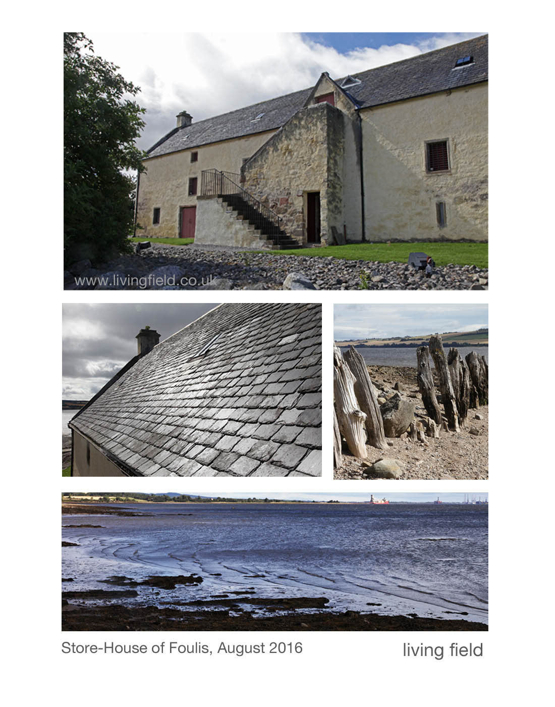
The Store-House of Foulis
Andrew Wight did not write about the girnal or store-house at Foulis Ferry Point. It was built 1740, that is 40 years before he passed by on his journey north from Inverness (and that’s about 275 years before now). It was built to store grain before it was shipped off to market or paid to people in kind for work or favours.
The grain was grown by the estate or paid as rent by the tenants of the estate. They would grow grain on a farm or allotment and pay some to the landowner. Beaton (1986) reports accounts that the total barley received at the Store-House of Foulis in 1784 came to to 169 bolls two firlots. Example of payments ranged from 98 bolls one firlot from the tenant of Mains of Foulis to two bolls from a slater.
The Store-House of Foulis (map reference NH 599636) today has been well restored, with its fine slate roof and well harled walls (images above). Though sometimes called Foulis Ferry Point, the ferry ceased to operate in the 1930s. New buildings have grown around the site housing a visitor centre, restaurant and shops.
There area is rich in these store-houses or girnals as they were called, along the Cromarty Firth and up to Portmahomak. Beaton (1986) gives a map of locations.
Andrew Wight’s comments on the area
Mr Wight (IV.I p 241 onwards) writes about the crops, the farm animals, the owners, the improvers, the tenants and the peasants. Here are some excerpts from his journey along the north side of the Cromarty Firth from Fowlis eastward.
Of Fowlis (Page 233), he regales against the old practices – “having a baulk between every ridge, upon which were heaped the stones removed from the ridges; the soil was taken off every third ridge, in order to ameliorate the two adjacent ridges; and the crops alternately oats and bere; and to this bad practice was added the worst ploughing that can be conceived.” But after the land was improved by the then owner, he reports (page 235) a wheat yield of ten bolls per acre.
And on the same estate, Robert Hall, the farm manager of Fowlis ‘introduced a crop, rare in Scotland and an absolute novelty in the north, which is carrot. (…..) The farm-horses are fed on carrots instead of corn; and they are always in good condition.”
I rejoice to see six yoke of oxen
At Novar he remarks on the poor inherent quality of the soil, which is more than compensated by the desire of the estate to effect improvement to a degree that today would be thought of as ecological engineering.
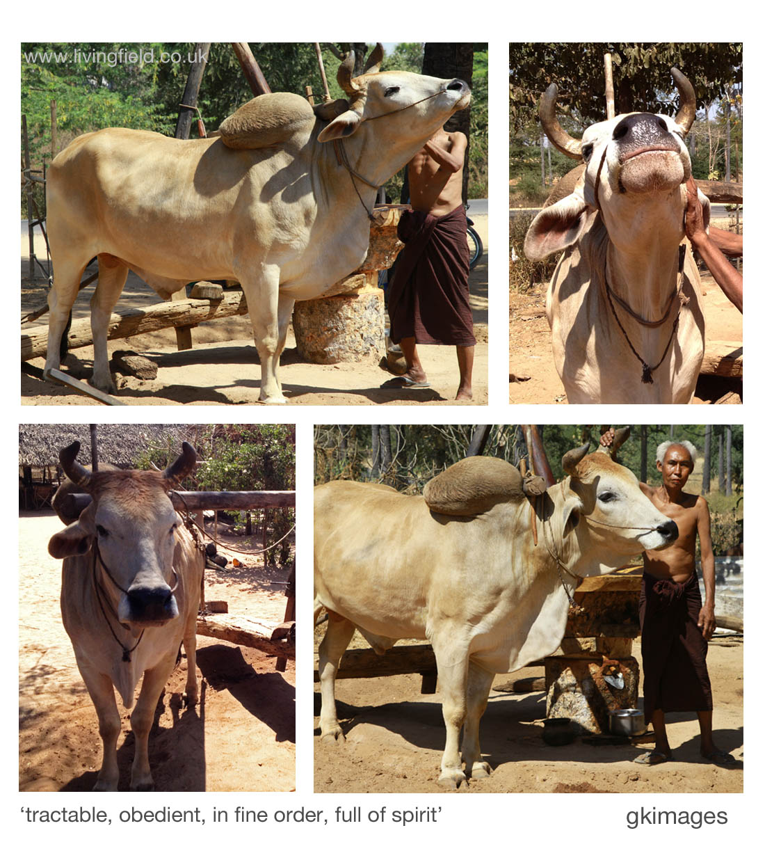
He notes “Oxen only are employed both in cart and plough. I rejoiced to see six yoke of oxen in six carts, pulling along great loads of stones, perfectly tractable and obedient to the driver. They are all in fine order, and full of spirit. They begin labour at five in the morning, and continue till nine. They are then put upon good pasture, or fed with cut clover, till two; when a bell is wrung, and all are ready in an instant for labouring till six in the afternoon.’
At Invergordon, he comments on seven crops: “wheat on this strong land was very good; barley after turnip excellent; beans and peas are never neglected in the rotation; oats in their turn make a fine crop; the old pasture grass excels.”
Agriculture, manufactures and commerce, the pillars that support the nation
Several pages are devoted to the contribution of George Ross of Cromarty, MP a man of “enterprising and comprehensive genius”. He started a hemp manufacturing company employing many people and exporting coarse cloth to London and then a brewery for strong ale and porter, much of it “exported to Inverness and other places by sea-carriage”.
On Ross’s agriculture: “it is wonderful to see barren heath converted into fertile cornfields; clover and other grasses rising luxuriantly, where formerly not a blade of grass was to be seen; horse-hoed turnip, and potatoes, growing on land lately a bog; ….. hay, not known here formerly, is now the ordinary food of horses and cows”. He also cures and exports pork: “… he carried me to a very large inclosure of red clover, where there were 200 hogs of the great Hampshire kind feeding luxuriously.”
Ross works on a plan for improving the harbour and entertains “sanguine hopes that government will one day establish a dry dock near the harbour for repairing ships of war in their northern expeditions.”
Ed: Writing in 1810 after Ross’s death, Mackenzie (1810) states that the hemp trade was “now in a flourishing state. From (the year beginning) 5 January 1807, there were imported 185 tons of hemp; and about 10,000 piece of bagging were sent to London”. Ross was not so far off in his hopes for ship repair – Mackenzie refers to a ship being built there in 1810, and today there are deep anchorage and rig maintenance.
Eight fields, eight crops in sequence
Later on page 257, Wight comments on Mr Forsyth of Cromarty who manages a small farm divided into eight fields, and cropped as follows: “First potatoes, horse and hand hoed, with dung; second, barley; third, clover; fourth, wheat; fifth, peas; sixth, oats or barley, with grass seeds; seventh, hay; eighth pasture. … in this way ‘kept in excellent order, with the advantage of dung from the village”.
Throughout his journeys, Andrew Wight speaks his mind, always ready to praise good farming and condemn poor practice. (You can sense these journeys are more than a job.) And while he accepts the social divides of the time – he was commissioned by the wealthy – notably between the landed gentry and their peasants, he condemns those of the former who ignore, ill treat or exploit and praises those who support and encourage the people to improve their lot by agriculture, manufactures and commerce.
Other points to note are that legume crops (fixing nitrogen from the air) were common in crop rotations and that bere and barley are both mentioned but no clear distinction is made between them (see link to the Bere line below).
Mackenzie, G S. 1810. General view of agriculture of the counties of Ross and Cromarty. London: Phillips.
Wight, A. 1778-1784. Present State of Husbandry in Scotland. Exracted from Reports made to the Commissioners of the Annexed Estates, and published by their authority. Edinburgh: William Creesh. Vol IV part I. (See Great Quantities of aquavitae for further reference and web links).
Those in the upper set were taken of the Foulis Store-house and its surrounds on a visit in August 2016.
There were no ‘yoke of oxen’ around Foulis and Novar in 2016, so the Living Field acknowledges with thanks use of photographs from Burma (Myanmar) by gk-images, taken February 2014 (permission granted by the handler to take the photographs). The quotes below the images come from Wight’s text of 1784, and apply well to this magnificent animal).
Maps of potato. legumes and vegetables in the region in the twenty-tens (and the relevance of this land over the last 2000 years?): Can we grow more vegetables?