The exhibition – Farming Fit for the Future – at Alyth Museum [1] in Perthshire shows how some farmers in Strathmore are regenerating the health and productivity of their land for a sustainable future.
[In progress – liable to editing 7 August 2024]
Agriculture here has a history of several thousand years. It has been through many cycles of decline and renewal. Some of the most effective changes in recent centuries –the Improvements – were introduced over several decades followed a devastating run of severe weather and resulting privation in the 1690s. The state of agriculture was later documented by farmer Andrew Wight on journeys beginning 1773 around mainland Scotland [2].
The Living Field looks back 250 years to the time of Mr Wight’s journals. What did he see as the main innovations or improvements in this part of Perthshire and Angus and how do they compare to the changes in land management described at the Alyth exhibition?
First – a look at the extent of managed agricultural land today, in Strathmore and beyond.
areaS of arable and managed grass TODAY
The agricultural census [3] records the area of land within several broad catagories. Arable or tilled land is typically ploughed and sown with cereals and other annual crops such as oilseed rape, potato and vegetables. Grassland, managed as grazing or hay for livestock, is separated into short-term (grown for less than 5 years) and long-term grass. A third broad category and the largest area, known as ‘rough grazing’, occupies mainly higher ground including the lower slopes of the hills. The main areas of production are the arable and managed grass.
Fig 1. Areas of arable land and managed grass (green colouring) in the early 21st century [4]. The dashed line shows the approximate position of the Highland Boundary Fault.
These categories are not permanent. Traditionally, and today still in some areas, short-term grass is sown as part of an arable-grass sequence. Also, land can switch between arable and grass – for example, large areas of arable land were moved into grass as recently as the 1980s and 1990s.
Arable crops and grass are cultivated mainly in low-lying regions to the east and south of the country, but they extend to parts of the far west and north (Fig. 1). For the western islands and much of the west mainland, thin strands of agricultural fields trace the boundary between land and sea.
At the east-centre of the mainland, the cultivated land is delimited by the Highland Boundary Fault (approximated by the dashed grey line in Fig. 1). Arable and grass occupy lower elevations to the south of the Fault. Rough grazing and non-agricultural land extend to the north. The climate and soil to the south of the Fault support a diverse agriculture which by global standards is highly productive.
Strathmore runs north-east from just above Perth, towards Alyth and on to near the coast. The Living Field post – Can we grow more vegetables? [4] shows the topography and boundaries of the strath, while Feeding the Romans [5] describes the line of watch towers, forts and fortresses that the invaders built just south of the Fault.
Figure 2. Arable and grass fields in productive land mostly to the south of the Highland Boundary Fault (see Fig. 1) in Perthshire, Angus and Fife. Letters show (D) Dundee, (P) Perth, (A) Alyth and (M) Montrose. Coloured dots indicate centres of fields growing mostly arable (dark grey) and grass (light purple).
North of Alyth on Fig. 2, it looks as if the productive land in Strathmore is putting out ‘feelers’ – testing the conditions in the expanse of unproductive white. But these thin strands are formed by fields immediately adjacent to the rivers that flow down through steep sided glens (valleys) across the Fault and into Strathmore. The boundary between land and sea is not shown on the map, but the fields define the coastline, including the shape of the Tay estuary between Perth and Dundee.
The copious supplies of water from the north and the rich soil south of the Fault, together with the maritime climate of this region, give Strathmore its great capacity for agricultural production. Farms in the exhibition [1] lie mostly in the arable-grass but some extend to higher elevations.
Improvements by the late 1700s
A major, systematic change in land management in lowland Scotland was stimulated during the 1700s by the ideas and methods of wealthy landowners such as Henry Home (1696-1782) and John Sinclair (1754-1835). They were unsure as to how far their innovations had been taken up by other landowners and their tenants. So to get the evidence, Andrew Wight, himself a farmer, was commissioned to ride around Scotland, visiting innovative farmers and documenting their methods and results. His findings were published in 1778 and 1784 [2].
[To be continued with …..the course of Mr Wight’s travels in Strathmore, his views on farming’s capacity to change …. ]
Author / contact: geoff.squire@hutton.ac.uk or geoff.squire@outlook.com
Sources | Links
[1] For the exhibition on regenerative agriculture at Alyth Museum – the Living Field post: Farming Fit for the Future.
[2] The Living Field web has several times used Andrew Wight’s records of journeys around mainland Scotland’s farming regions, for example at The Mill at Atholl and Great quantities of Aquavitae. Wight, A. 1778-1784. Present State of Husbandry in Scotland. Exracted from Reports made to the Commissioners of the Annexed Estates, and published by their authority. Edinburgh: William Creesh. Vol I, Vol II, Vol III Part I, Vol III Part II, Vol IV part II, Volume IV Part II. All available online via Google Books. With thanks.
[4] The original map, from which Fig. 1 was derived, was constructed by Nora Quesada Pizarro and Graham Begg, working with Geoff Squire, at the James Hutton Institute, Dundee. The original was edited by the author to show approximate areas of managed arable and grass. The background data and the method of constructing this and similar maps by Hutton researchers, have been described on the Living Field web at Can we grown more vegetables. The map in Fig. 2 was constructed from grid coordinates for fields separated into broad categories of arable and grass.
The geologist James Hutton’s visit to Arran in 1787. His discovery of an Unconformity between two rock strata leading to new understanding of geological time.
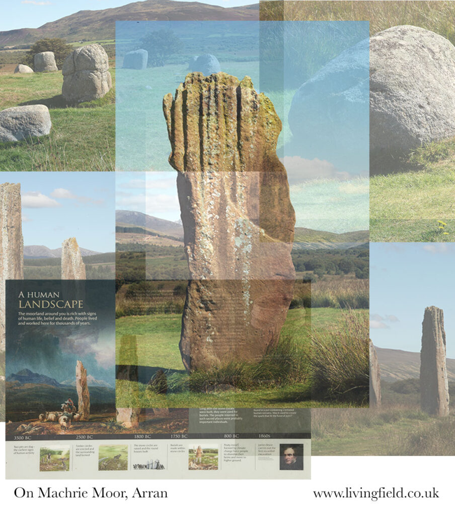
The Isle of Arran has signs of an ancient past, both in its geology and its early civilisation. A visit in late August aimed to look at evidence of its post-glacial land use, specially in the Neolithic and Bronze Age. But its geology draws you in and leads you to the observations and inferences made by the geologist James Hutton over two centuries ago. Here, the Living Field muses on Hutton’s Unconformity. The stunning ritual landscape on Machrie Moor, and the agriculture that supported it, will be described later.
Scenes from Machrie Moor, Arran – a landscape of ancient stone circles, more space and more spiritual than Carnac, Stonehenge and even Callanish.
Hutton’s Unconformity in north Arran
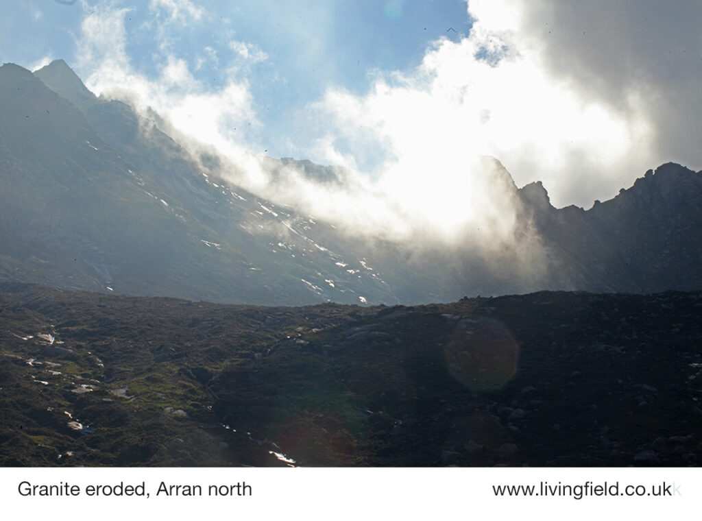
The centre of the northern part of the Isle of Arran is made of granite, formed by volcanic activity, and since eroded by glaciers and weather into a series of sharp peaks, ridges and U-shaped valleys.
The nearby coastal fringes are not granite but a mix of mainly sedimentary rocks, and it was near the northernmost coastline that James Hutton discovered his Unconformity when he visited the island in 1787. (That’s more than 230 years ago!)
Taken from Glen Sannox, towards a ridge of jagged peaks made of granite, the lower land eroded by glaciers and weather (www.livingfield.co.uk).
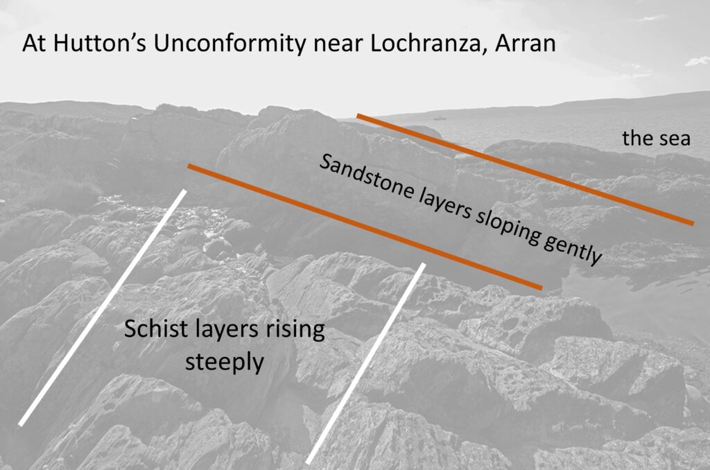
The detail and significance of the find are told at the information centres and web site of Arran Geopark [1] and in various books on Hutton [2]. Briefly, the Unconformity arises at the junction of two types of sedimentary rock: very old sandstone (350 million years) and even older schist (540 million years).
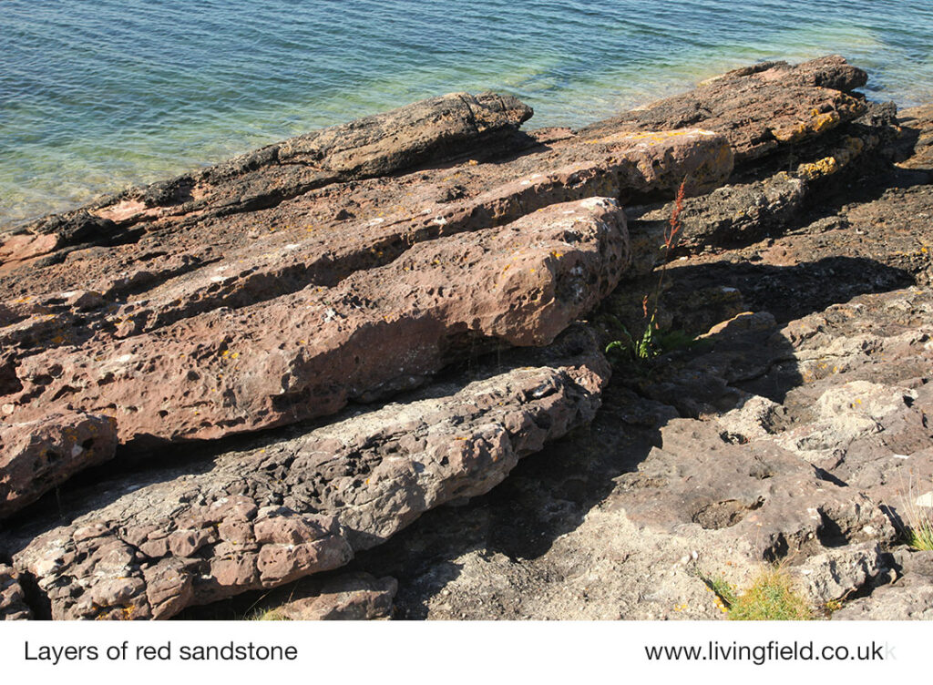
Strata of Carboniferous Sandstone, just a few metres to the left of Hutton’s Unconformity, a welcome platform for reclining on a hot summer’s day, feet cooling in the sea, 31 August 2022 (www.livingfield.co.uk).
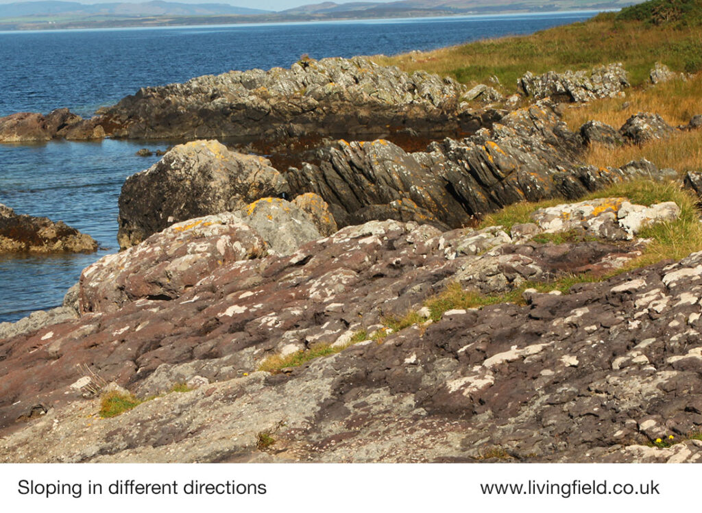
Both sandstone and schist were formed by compression of sediments layed down horizontally, but then contorted and eroded so that they are visible today at very different angles: the older schist rising steeply right to left (looking north in the photograph below) and the sandstone rising left to right but at a shallow angle.
Photograph taken on the red sandstone which forms a gentle slope rising to the right, looking towards the dark grey schist in the middle distance, rising steeply to the left, 31 August 2022 (www.livingfield.co.uk).
Today the Unconformity is marked by a sign on a geological trail, but without its aid you could easily miss the junction of the schist and sandstone. Hutton was not previously aware of the phenomenon, but on seeing it, understood its significance. As the Walking Guide to the Arran Geopark [1] states: “He reasoned that such a structure must have taken millions of years to form. From his observations on Arran, Hutton concluded that the earth must be much older than previously thought, and introduced the concept of ‘deep time’ to the scientific community.”
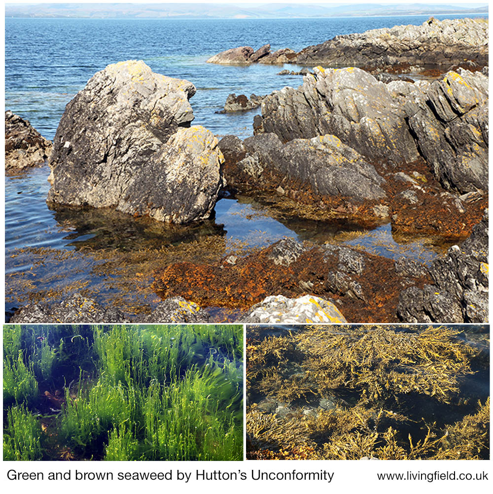
Photograph, annotated, taken from the opposite direction to the one above, showing the junction of the two strata. The green seaweed in the photograph below lay to the lower right where a freshwater stream runs into the sea..
On the seaward side of the geological unconformity was a botanical one – a small circular grove of green seaweed (Ulva intestinalis) within an extensive area of brown wrack, mainly Ascophyllum nodosum and several Fucus species. The cause was a freshwater stream running into the sea and de-salting the water enough for the Ulva.
The shore near Hutton’s Unconformity hosted an abundance of seaweed, a freshwater stream allowing the green Ulva intestinalis, lower left, to live next to brown wracks, lower right (www.livingfield.co.uk).
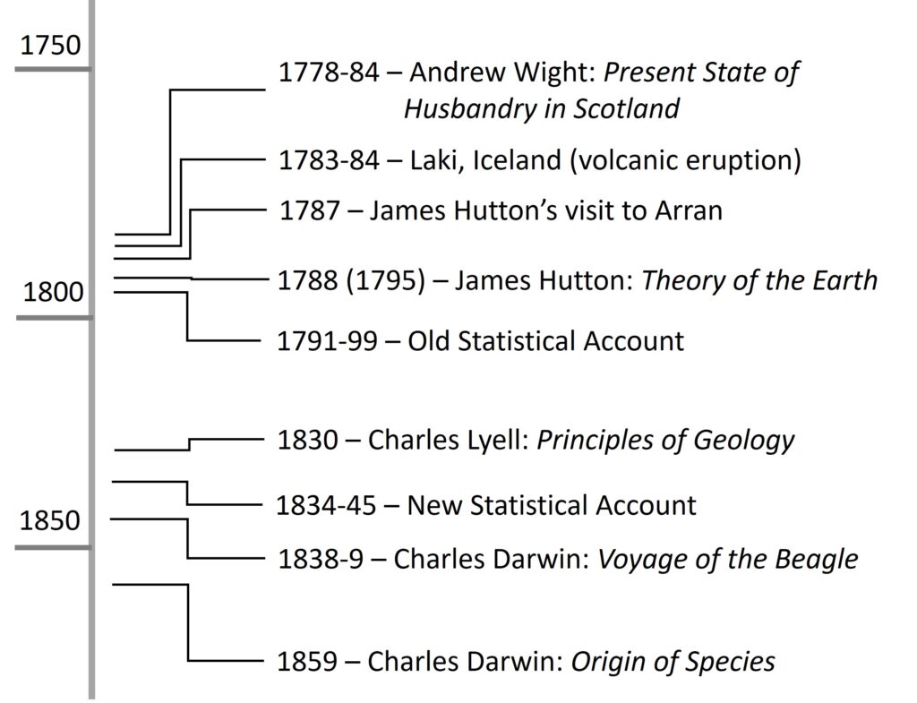
James Hutton worked during a period of immense activity in science and technology. His publications pre-dated those of more famous scientists: for example, Theory of the Earth first appeared five decades before Charles Darwin went on his Voyage of the Beagle [3]. It was also a time when the earth reminded people of their fragility. The Laki eruption in Iceland, 1783-84, devastated crops and livestock, causing many to die of hunger, and made its presence felt much farther afield [4].
Hutton also practiced and wrote about farming and food production, contributing to the drive to restore soil fertility and raise agricultural output [2]. A few years before Laki, and Hutton’s visit to Arran, Andrew Wight began his definitive survey of agriculture in Scotland, which in time led to the first systematic inventory, the Old Statistical Account [5].
Timeline of some important studies in geology and agriculture in Scotland after 1750. For sources: [3], [4], [5] (www.livingfield.co.uk).
[2] There are several books on the life and science of James Hutton (1726-1797), the following published with the aid of a grant from the James Hutton Foundation: McKirdy, Alan 2022 (1997) James Hutton the founder of modern Geology. National Museums Scotland.
[3] Charles Darwin’s Voyage and various editions of his books are described at Darwin Online.
[4] Laki volcano, Iceland. For a recent analysis: Dawson AG, Kirkbride MP, Cole H. 2021. Atmospheric effects in Scotland of the AD 1783-84 Laki eruption in Iceland. The Holocene 31, 830-843. Available online.
[5] Andrew Wight’s 1778-84 definitive survey of agriculture: Wight, A. 1778-1784. Present State of Husbandry in Scotland. Extracted from Reports made to the Commissioners of the Annexed Estates, and published by their authority. Edinburgh: William Creesh. Vol I, Vol II, Vol III Part I, Vol III Part II, Vol IV part I, Volume IV Part II – available online via Google Books. His work has been used many times on the Living Field web site, for example Great quantities of Aquavitae, The mill at Atholl, Gool rider gool rider, and articles in the Bere line. The Old and New Statistical Accounts are available online at The Statistical Accounts of Scotland 1791-1845.
The photographs and notes in this article were taken during the editor’s visit to Arran in late August 2022. Contact geoff.squire@hutton.ac.uk or geoff.squire@outlook.com
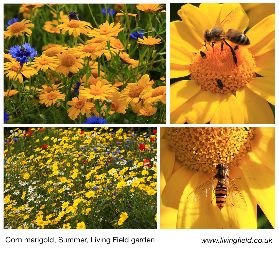
The gool or corn marigold, for centuries an injurious weed. Its control by monastic order. Its decline in the 1900s and its rarity today except in wildflower seed mixtures. But will its recent reappearance in fields revive the ancient tradition of gool riding?
The gool, the Corn marigold Chrysanthemum segetum, was a pernicious weed. It ravaged the croplands in the middle ages [1], was tamed to a degree by the monastic improvements after 1200, and was finally brought in check late last century by mechanical cultivation and chemical weedkillers. Was it eradicated – not entirely? It’s still with us, seen emerging in stubble this autumn in a few east Perthshire fields.
Of all the main crop pests In Britain, weeds are now considered the most controllable and least damaging, but for most of history they were the scourge of agriculture.
The problem lay in the uncleanliness of saved seed. Corn crops, mainly barley, oats and wheat, were sown each year using seed saved from a previous harvest. If weed seeds were harvested with the corn, then the weeds were sown with the new crop. Seed would also reside for years in the soil ‘seedbank’, so that even if sown corn was clean of weed seeds, some from the seedbank would germinate and emerge when the soil was cultivated.
Good monastic practice
To avoid major weed problems, seed and soil had to be kept low in weed seed over a run of many years. Franklin [1] reports that gool was one of the most troublesome of the weeds that limited corn yields during the period of agricultural improvement initiated by the new monastic houses, such as Coupar, established in the late 1100s. The monks, and the lay brethren who did the farming, were aware of the need to keep seed and fields clean, and were able to achieve good agricultural yields and self-sufficiency.
Gool had such importance that it was named in leases from Coupar Abbey to agricultural tenants in the 1400s. The tenants were charged with certain tasks – to maintain trees and hedges, to include the soil-improving peas and beans along with corn in the rotation, to ‘labour for the gaining of the marsh’ (probably referring to the draining of the Carse of Gowrie) … and to keep the land free of corn marigold. Not everyone was as mindful as the monastics, but to encourage good practice tenants of Coupar Abbey were fined in the 1470s because they allowed gool on their land.
Today, the gool is not a problem. Rather its loss for most fields is seen as a negative. The marigold adds colour to the landscape and offers food for many invertebrates. Crop seed is sourced mainly from specialist seed merchants who ensure that ‘seed’ crops (those grown for seed rather than food or feed) are free of weeds. And even if it were to emerge in fields, modern control measure would remove it.
Gool riders approaching
Imagine being there in those mediaeval times and – weeds being weeds – they have this habit of just turning up whatever measures were taken to control them. Or maybe control lapsed and the gool took advantage and spread, wreaking havoc in the cereal crops.
And then in the early hours, distressed cries shatter the peace – “Gool riders approaching”. People scramble to pull on their clothes rush out to beat up any nearby gools and then head for the woods or whatever hiding place they can find to escape the landlord’s wrath.
Fanciful perhaps, but gool riders were a reality: “certain persons, styled gool-riders were appointed to ride through the fields, search for gool, and carry the law into execution when they discovered it” [1]. The riders were appointed (it seems) by major landowners: fines could be severe – a sheep for a gool.
Time out of mind
How widespread was the pursuit? Both Franklin and the Scots Dictionary [2] cite the one report in the Old Statistical Account [3] for Cargill, Perthshire. The Account was published in 1794 and refers to gool riding only as an old custom, so it is unclear when the riding ceased. The threat of the riders and the fines seemed to have worked because the Account reports that once tenants learnt to control the weed, the ‘gool-riders can hardly discover as many growing stocks of gool, the fine for which will afford them a dinner or a drink.’
There’s another mention of it, this one in Andrew Wight’s travels of 1778 [4]. In the barony of Stobhall, at Campsey (not far from Cargill), he tells of ‘a singular practice, which is called riding the guild‘, whereby a committee of tenants ‘on a certain day in August, examine every field, ….. and for each stalk of that weed found at this time among the corns, the committee fine the tenant in one penny or two pence’ and ‘by the observance of this salutary practice, the whole lands ….. are perfectly clean : whereas if we turn our view to the neighbouring lands, many of the fields are covered with more guild than corn.’
Wight enquired when the law was introduced and reported that ‘The people have no tradition relative to the time and manner of its beginning; only that, in time out of mind, such has been the practice’.
Today the corn marigold is common in sown annual wildflower displays, blending its yellow with the red of poppy and the blue of cornflower. Maybe some escape, the seed falling into people’s wellies and turn-ups, and eventually find their way into fields.
The gool shown in the cereal stubble at the top of this page grew mostly after harvest and flowered late, in October. It might have lain dormant in the seedbank, or came to the field in as a seed impurity or casual immigrant.
In the face of modern competitive crops and weed control, the gool is unlikely to wreak the havoc that it did. Its continued presence and reappearance serve to remind that food security was once threatened by weeds here, as it is now in many other parts of the world, and that there might be opportunity for this attractive plant to coexist with today’s agriculture.
Sources | links
[1] Franklin, T Bedford. 1952. A history of Scottish Farming. Thomas Nelson & Sons Edinburgh.
[2] Old Statistical Account, 1794. Cargill, County of Perth, Volume XIII by Rev Mr J P Bannerman.
[3] The Scottish National Dictionary (1700-) cites many variations including gool, gule, gweel and guild, https://dsl.ac.uk/entry/snd/guil. One entry refers to a guil-sieve as a small mesh sieve in the threshing mill which cleans the corn after it has come through the riddle.
[4] Present State of Husbandry in Scotland 1978, Vol I, page 35. The author Andrew Wight is not credited. Available online, search for the title. More on Andrew Wight’s travels at Great quantities of aquavitae II.
Author/contact for this post: geoff.squire@hutton.ac.uk ot geoff.squire@outlook.com
The historic watermill at Blair Atholl. Absence of corn growing in the surrounding area today. Extensive field systems and enclosed land in the mid 1700s. Andrew Wights 1780s descriptions of innovation, enterprise and crop diversification. Part of a Living Field series on old corn mills.
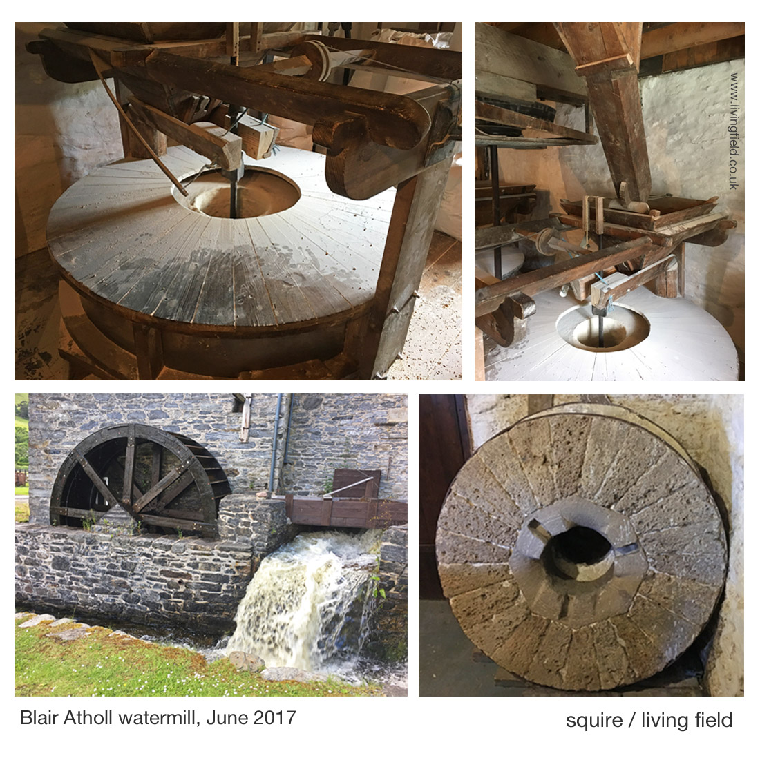
The watermill at Atholl [1] offers a welcoming break to journeys along the A9 road, offering – in addition to the working mill – coffee and freshly baked bread from a variety of grains. In 2017, the mill and its bakers gained some deserved exposure on a BBC2 television programme, Nadiya’s British Food Adventure, presented by Nadiya Hussain [1].
The remaining corn mills in the north of Britain tell much about the phasing in and out of local corn production over the last few centuries. The Living Field’s interest in this case lies in the mill’s history and location, being a substantial building but presently in an area that has no local corn production. In this, it differs from Barony Mills in Orkney which lies within an area of barley cultivation that still supplies the mill [2].
The images above show the water wheel fed by a lode that runs from the river Tilt to the north, the main grinding wheel (covered, top l), hoppers feeding the wheel and an old mill wheel. The watermill’s web site [1] and the explanation boards in the mill itself describe the history of the building and workings of the machinery.
The Atholl watermill was a substantial investment, but what strikes today is the absence of corn-growing (arable) land in the area. When visited in 2017, very few fields were cultivated.
What do the historical maps tell us?
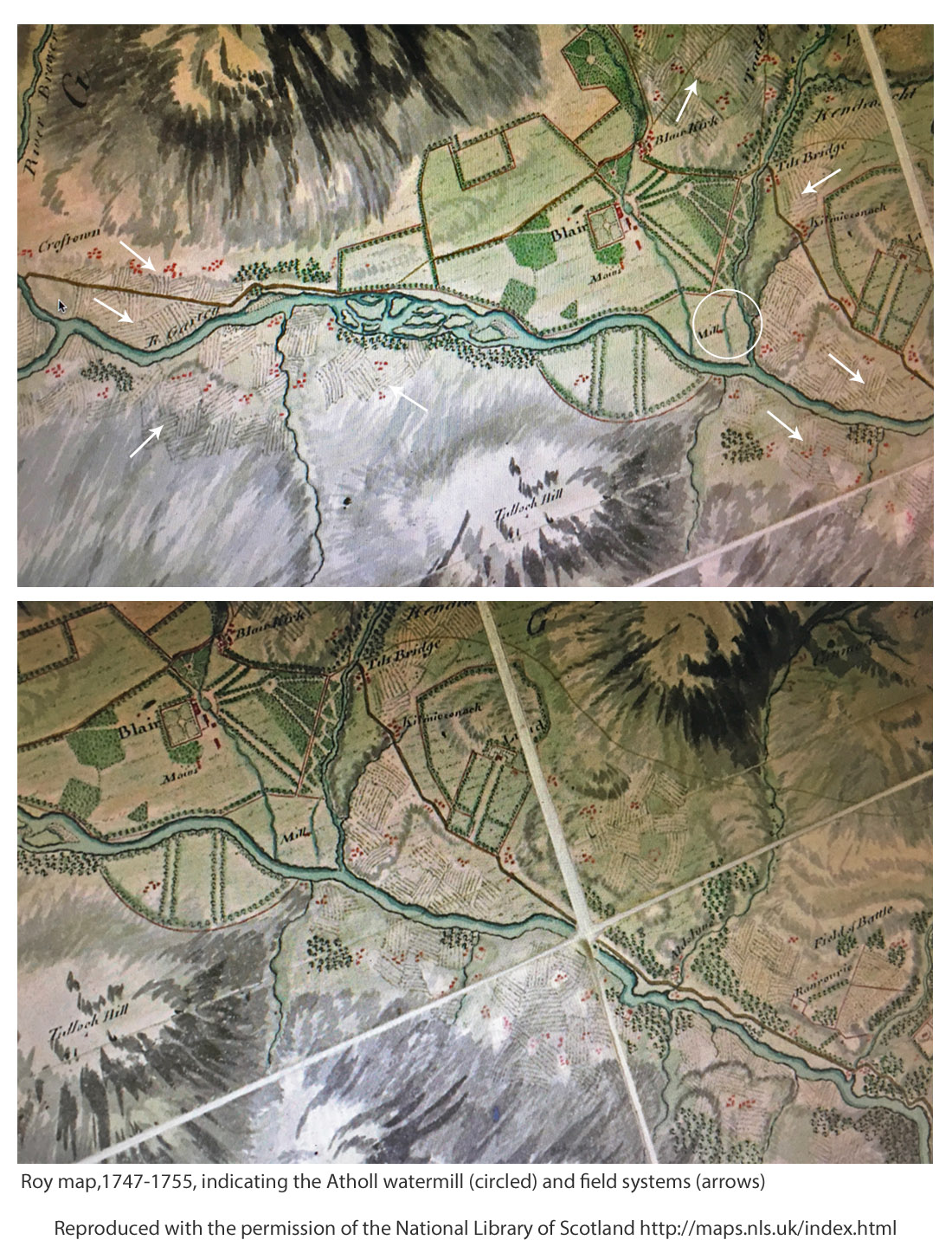
The information inside the mill states that it was present at the time of Timothy Pont’s map of the 1590s [3]. It is there on his map, just south of ‘Blair Castel’. But Roy’s Military Survey [4] of the mid-1700s gives the best indication of the possible extent of cropped land in the area. Features on the Roy map (copied below) include ‘Blair Kirk’ (church) which still stands at what is now known as Old Blair and ‘Tilt Bridge’ on the road that ran north of the Garry; then areas of enclosed land or parkland, bounded by tree lines; and the Mill, shown within the white circle in the upper map, with its lode clearly leaving the River Tilt to the north and flowing past the mill to enter the River Garry upstream of where the Tilt joins it.
The Roy Map shows what appear be clusters of field systems on both sides of the Garry, depicted by short parallel lines suggesting rigs, some indicated by white arrows on the upper map. The lower map has been displaced to show more field systems around Aldclune.
Later, on the first edition of the Ordnance Survey 1843-1882, the village of ‘Blair Athole’ has started to take shape, the corn mill is marked being fed by a Mill Lead originating at a sluice off the River Tilt. Later still, the Land Utilisation Survey 1931-1935 shows arable land remaining, consistent with the location of many of the field systems on Roy’s map.
Therefore crops, and they must have included corn, whether oat or barley, were grown in the region and presumably fed the mill, but more information on what was grown was reported by Andrew Wight, travelling 30 years or so after Roy.
Andrew Wight’s survey of 1784
Mr Wight’s surveys of agriculture in Scotland in the 1770s and 1780s again provide rare and sometimes surprising insights. He meets and reports on mainly the improvers, the landowners and their major tenants, less so the householder and small grower. Yet he was there at a crucial time in the development of food production and able to present a unique and consistent account throughout mainland Scotland.
Part way through his fourth survey [6], he spent the night in Dalwhinnie, then on travelling south towards lowland Perthshire, he stopped at Dalnacardoch, commenting that the innkeeper was a ‘spirited and enterprising’ farmer. There he reports a “clover field, dressed to perfection; an extraordinary sight in this barren country” and also “turnips in drills in perfect good order, pease broadcast, bear and oats with grass-seeds”, and notes ‘great crops of potato are raised here’. [Ed: bere is a landrace of barley.]
On ‘Athol House’ (near the mill) he concentrates on the animals, various breeds and hybrids of cattle, and also sheep; but on the tilled land, he writes the “Duke’s farm is about 700 acres arable; of which not more than 120 are in tillage, the rest being hay or pasture.” The rotation is “turnip broadcast, barley, oats and turnip again”. So corn crops – barley and oats – occupied 2/3 of the 120 acres, equivalent to 80 acres or 32 hectares (abbreviated to ha, 1 acre = 0.405 ha). It is uncertain what this land yielded at that time, but assuming it was 1 t/ha or one-fifth of todays typical spring cereal harvest, then that’s 30 tonnes of corn annually. By itself it does not seem enough for such a big mill.
Again, it is unclear whether tenants and crofters are included in the stated area, but they were probably not. For example, later he mentions tenants, including the innkeeper and farmer at ‘Blair of Athol’ who grew corn for his own local consumption. The extent of other corn land cultivated by small tenants, for example, on the field systems shown in the maps above, is not mentioned.
Mr Wight continues in his appreciation of the standards as he moves south, finding after Killicrankie and towards Faskally, an enchantment of orderly farmland. On the road south to Dunkeld, he writes ‘hills on every side, some covered with flocks, some with trees and small plantations, mixed with spots of corn scattered here and there; and beautiful haughs variegated with flax, corn and grass.’
Driving along the A9 road today, the land flanking the Garry seems impoverished and the climate inhospitable for crops, but Wight presents an entirely different view: innovation, improvement, and diversity of plant and animal husbandry. As in many upland areas, the land reverted to poor pasture, in some instances as recently as the 1980s. Why? Higher costs of growing crops, low profit margins, easier alternatives based on better transport connections and ready imports of cereal carbs.
[4] Roy Military Survey of Scotland 1747-1755 http://maps.nls.uk/roy/ The web site of the National Library of Scotland (NLS) allows educational and not-for-profit use: acknowledgement given on the map legend.
[6] Wight, Andrew. 1784. Present state of husbandry in Scotland Volume IV, part I. Edinburgh: William Creech. The sights noted above, between Dalwinnie and Dunkeld, are described at pages154-165. [Available online, search for author and title.] Other reports of Mr Wight’s journeys are given on this site at Great quantities of Aquavitae and Great quantities of Aquavitae II.
Vegetables and fruit in Scotland mapped. Regions of historically strategic land and soil. The Iron Age, then the Romans, Picts and 1700s Improvers. Imports vs local production. Opportunities.
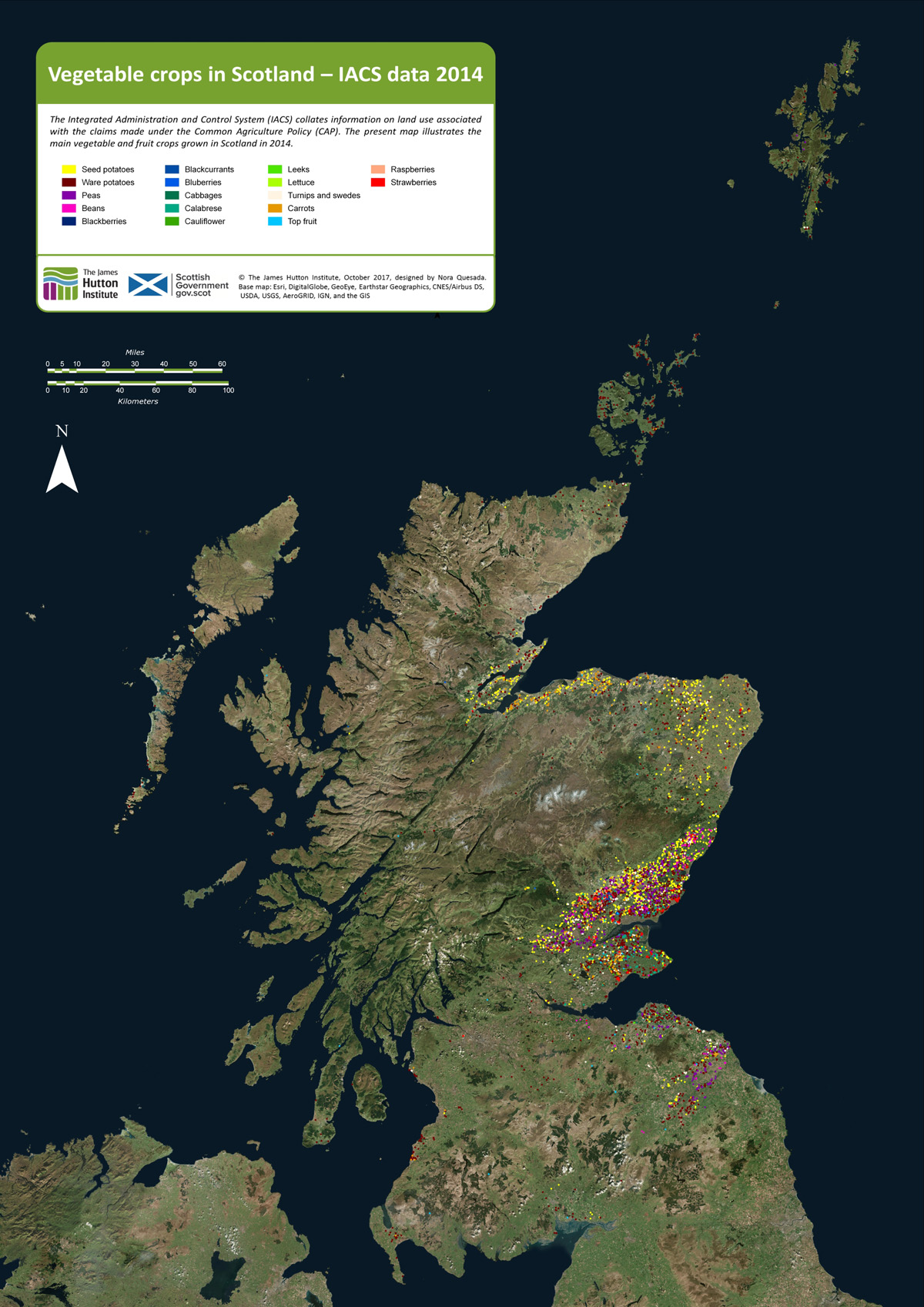
As background to the recent Vegetable Summit, held in Edinburgh, London and Cardiff, Nourish Scotland [1] asked the James Hutton Institute if it was possible to define the places where vegetables are grown in the region. The resulting map, prepared by Nora Quesada, is shown below.
Click on the map to open a larger version in a separate tab
Each coloured dot on the map indicates a field of fruit or vegetables. (The dots are much larger than individual fields.) It is clear from the distribution of dots that relatively little land exists in Scotland on which vegetables and fruit are grown. Even in places where the coloured dots are concentrated, the land area covered by fruit and vegetables is generally less than a few percent. Most of the other cultivated land is under cereals, wheat and barley.
Why do we want to know where vegetables are grown? Questions around diet, health and food poverty at this time of agricultural plenty were raised in a recent issue of Nourish Scotland’s magazine, January 2017, with the title ‘What would Boyd Orr do?’ [2].
John Boyd Orr was a pioneer of research into nutrition in Scotland many decades ago. His work became known throughout the world. The article asked what he would do today faced with the situation that, while vegetables are essential for a healthy human diet, most are imported and fail to reach the people that need them.
It is important to know therefore whether more land than shown on the maps can be converted to growing vegetables? For example, how much land would be needed to provide an optimum (rather than minimum) diet for the whole country from local produce; and can the cities be supplied with fruit and veg by the land surrounding them?
To answer such questions, it is necessary, first, to know what is grown and where. That is the purpose of the present mapping.
How is it done?
The EU’s Integrated Administration and Control Systems (IACS), which is used to manage farm subsidies, collects data on the crops grown on each field. The Scottish Government provided that information to the James Hutton Institute. Each field in IACS is geo-referenced and can be located on a base map that is of high enough resolution to show the outlines of the fields. The IACS reference then allows the fields on the base map to be linked to specific crops in specific years. This is how the maps shown in this article were constructed [3].
The IACS system does not account for vegetables from gardens and allotments and inner city and rural small scale production. There is much activity at these small scales, which we’ll look at in future posts.
Here we consider two examples of areas where vegetables are now produced: Strathmore and Angus and then Moray, Cromarty and Tarbat. Commercial growing needs good soil and a not-too-extreme climate, and given the difficulty of finding this combination in Scotland, it becomes apparent that today’s vegetable-producing regions have had strategic importance for hundreds and even thousands of years.
Strathmore and Angus
The main area for production of vegetables lies in Strathmore (map below), which stretches over a generally lowland region, from east of Perth and then in a north-east direction to the coast north of Angus. Angus itself is a major source of fruit and many types of vegetable. Across the Tay, parts of Fife are similarly productive.
The crops occupying the greatest surface area are still the cereals – barley and wheat – but they are not shown on the map. In addition to potato and a wide range of vegetables, this area is the centre of fruit growing in Scotland – strawberries, raspberries and blackcurrants.
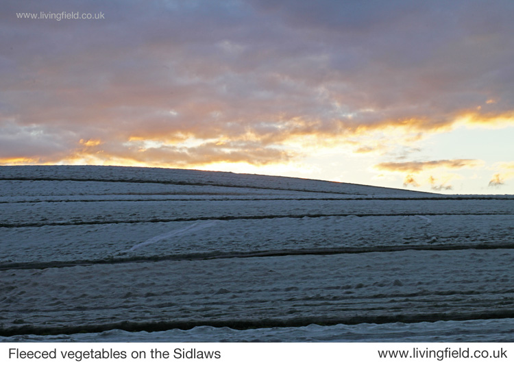
Increasingly in recent decades many vegetables are sown in the field then covered with a protective fleece to encourage early growth and to distance them from pests. Similarly, most soft fruit growing today is under the protection of polytunnels, where again the environment is less severe in winter and pests can be regulated.
Strathmore, Angus and Fife showing approx. locations of fields growing vegetables in one year.
The fertile soils and maritime climate here were of strategic importance to the iron age communities who built their many hill forts along the Sidlaw Hills that form a barrier between Strathmore and the estuary and coast to the south. The famous Dunsinane, or Dunsinnan as it is referred to on old local maps, is one of them [4]. One of the photographs shown below was taken from Dunsinnan, north across Strathmore.
Later the Romans invaded, moving north from the region of Hadrian’s Wall, not finding much of a welcome it seems, and erecting forts and watchtowers along the Gask Ridge and in a line just within but near the northern extremity of the cloud of coloured dots in the image above [5].
The Romans’ massive Legionary Fortress at Inchtuthil, within the northern boundary of the strath (see map above), was built and deserted in the 1st Century AD, and was probably sited to guard the passes north along what is today’s A9. The fortress and marching soldiers would have needed constant supplies of food, and probably achieved this by access to the rich land of Strathmore.
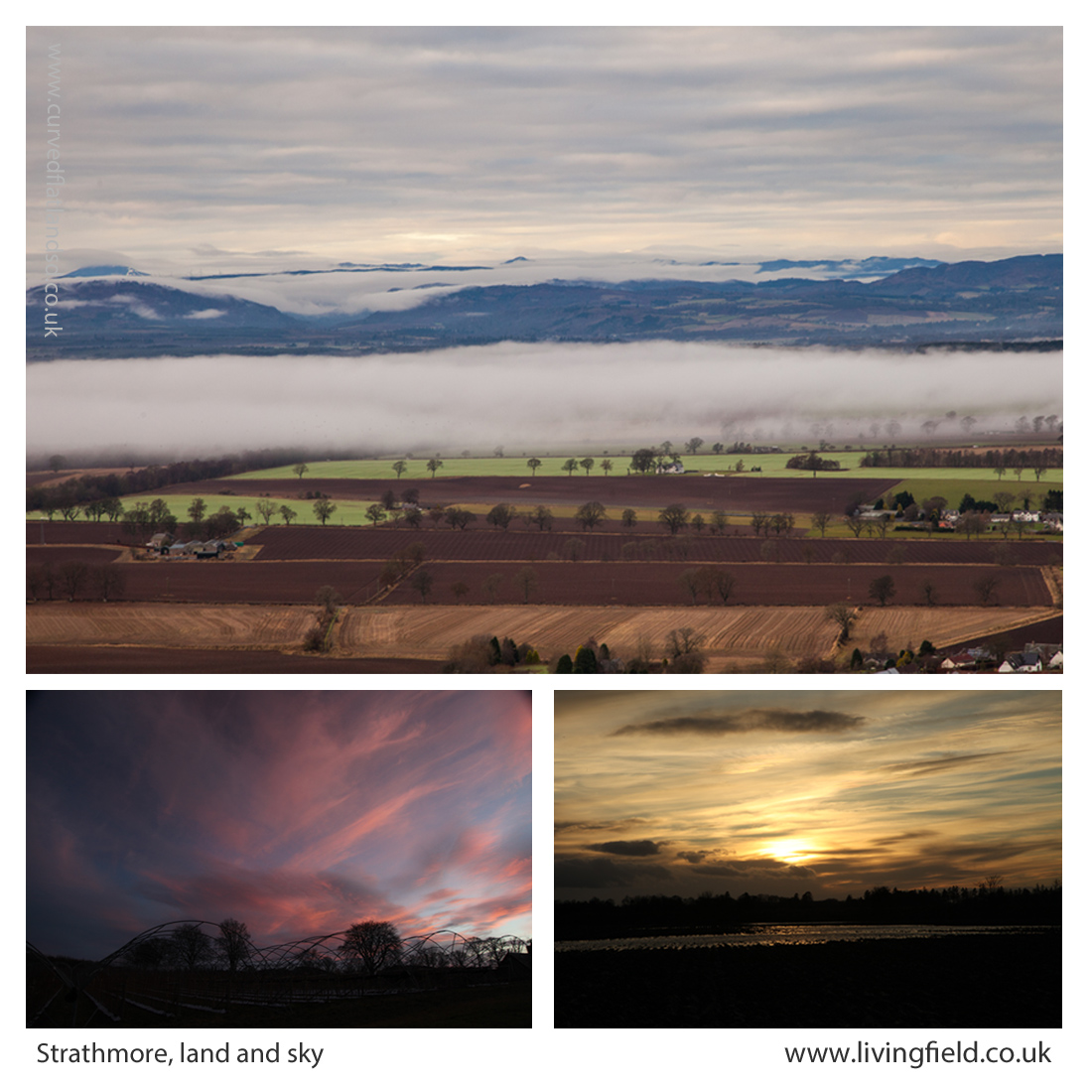
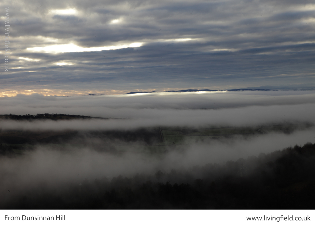
From Dunsinnan Hill north across Strathmore (top), the Isla in flood at the the last sunset of the year (lower r) and winter sky above polytunnel frames (www.livingfield.co.uk)
The image at the top of the three above was taken from Dunsinnan early in year, looking across Strathmore. The nearest fields are still in stubble after last year’s harvest; the intermediate ones, showing rich brown soil, have been ploughed; and the green ones just beneath the low cloud were sown the previous autumn with winter cereals or oilseeds. The Roman line stretched this side of the hills.
Centuries later, the Picts made this productive region integral to their southern kingdom in the 7th and 8th centuries. Many symbol stones and ‘pit- ‘ place names survive here from that time [6]. Some of the crops grown here today would not be known then – potato, for example, was yet to cross the Atlantic, and the other ‘root’ crops – turnip and swede – were probably unknown.
Yet Strathmore, Angus and Fife would have offered enough agricultural land to feed this civilisation with its basic grain and protein. You can see it was a prize that other peoples would want to take for their own – the Scots moving across from Ireland would have found little land of comparable quality on the west coast.
The Black Isle, Moray, Tarbat, Cromarty
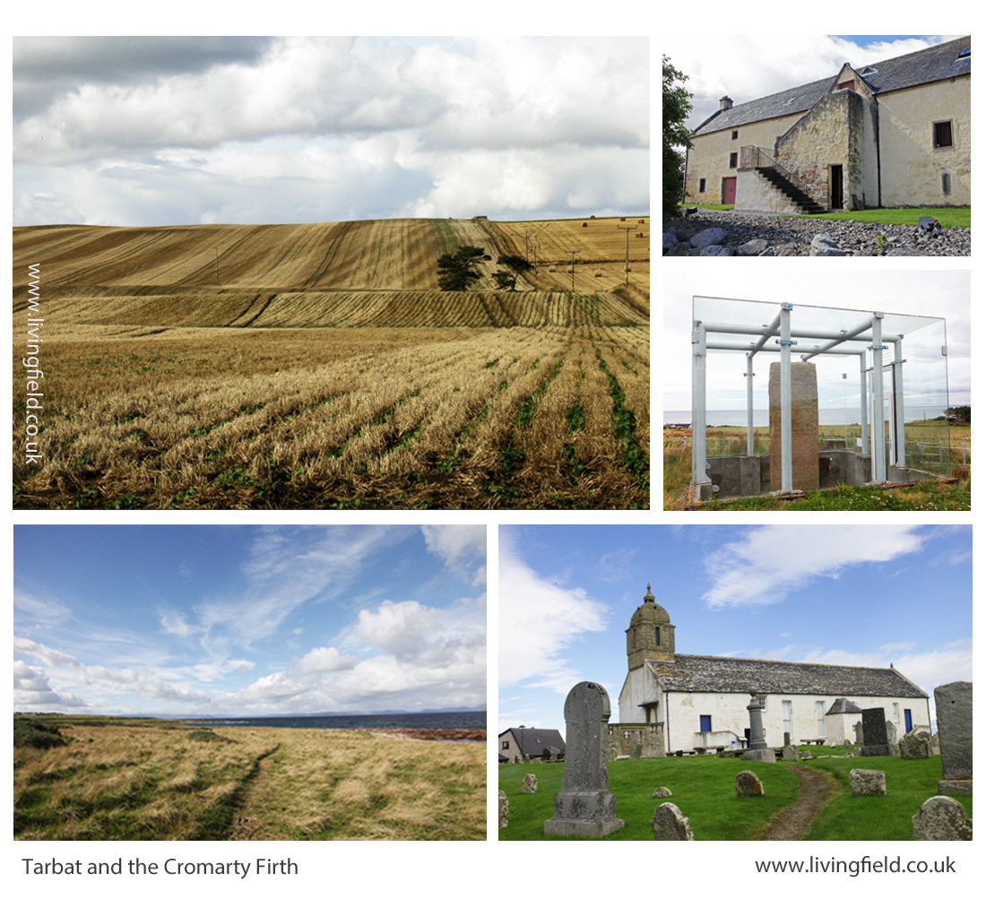
A hundred miles directly north of Inchtuthil Fortress, across today’s passes of Drumochter and Slochd, the land falls to the coast and becomes productive again. The area (map below) grows fewer types of vegetable today than Strathmore, but grain and tuber yields remain high.
The coloured dots show that seed and ware potato were the commonest vegetables in this region, but interestingly carrot is also prevalent. Go back to the 1780s and the farmer/traveller Andrew Wight had this to relate when riding along the northern side of the Cromarty Firth [7]:
“….. that Robert Hall, the farm manager of Fowlis ‘introduced a crop, rare in Scotland and an absolute novelty in the north, which is carrot. ….. The farm-horses are fed on carrots instead of corn; and they are always in good condition.”
Andrew Wight visited the area as part of his survey of the Improvements in the late 1700s, but the rich coastal land here has a historical legacy stretching back centuries.
The map above shows the area around the Cromarty and Moray Firths, the Moray coast stretching to the right and the Black Isle left of centre.
The northern Picts established their ‘elite’ farm and monastery at Portmahomack on the northern tip of the Tarbat peninsula. Their massive carved stones, at Nigg, Cadboll and Shandwick, were major contributions to European art. They arose within a civilisation based on the stability afforded by this good agricultural land [6].
As for Strathmore, the rich soil around the Dornoch and Cromarty Firths must have been eyed by the Scots from the west and the Norse from the east. Pictish civilisation, with its distinctive art and craft, did not survive.
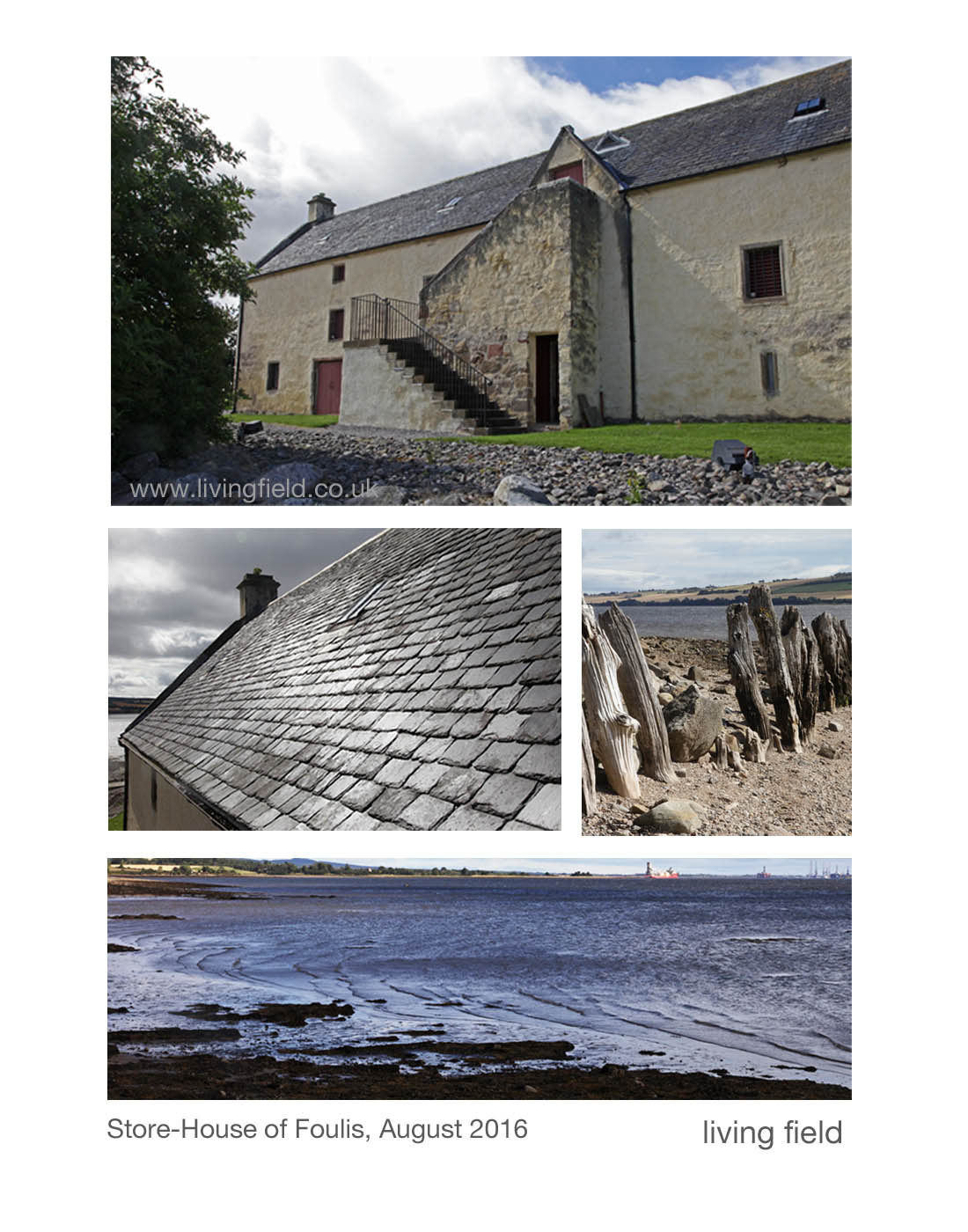
Lines in the earth, Tarbat, including rapeseed drilled directly into cereal stubble (top left), then clockwise, the Storehouse of Foulis built in the 1700s; the Picts’ Shandwick Stone; site of the Tarbat Discovery Centre; and coastal grazing looking from Tarbat across the Dornoch Firth (www.livingfield.co.uk)
Opportunities
The maps derived from IACS data show the extent of vegetable growing today. Vegetables and fruit could be grown over a much wider area and a much higher density if the demand was there.
For example, the pulses – beans and peas – plants that fix their own nitrogen and so save on mineral fertiliser, have been reduced to a minor crop. The IACS map shows concentrations of peas and beans in the Borders, but overall the pulses cover less than 5% of the arable land. This is low by global standards. Countries that have transformed their agriculture in recent years now assign a quarter of their land to nitrogen-fixing crops.
Developments towards greater veg and fruit production and nitrogen fixing pulses will not be just though existing growers expanding their production. There are many local initiatives, some in areas considered inhospitable for vegetables. There is great scope therefore for increasing production but the demand for quality local produce has to be there from consumers.
Future posts on this web site will look at the value of fruit and veg to health, the degree to which Scotland depends (and it depends a lot) on imports for its fruit and veg, the new vegetable products that are appearing on the market (including beer and bread from beans), the increasing local initiatives in veg production and the possibilities for growing much more fruit and veg and making it available to those who need it.
For more on vegetables on the Living Field web site…
Next up –Veg at Bangkok markets, Thailand and Minerals and vitamins from vegetables and fruit.
From Dunsinnan, across Strathmore, early in the year 2017
Sources, links
[1] Nourish Scotland: The Vegetable Summit was held on 24 October 2017. For background see Peas Please – the Veg Project.
[2] What would Boyd Orr do? Nourish Scotland Magazine, Issue 6, January 2017. The link is to a pdf file. The article by Pete Ritchie explains John Boyd Orr’s contribution and his continuing relevance today. Other articles cover diet, food poverty, vegetables and right to food.
[3] IACS and map construction. Information of the Integrated Administration and Control System IACS scheme can be found at the web pages of the European Commission and the Scottish Government. Examples of a major exercise in mapping based on IACS data are given in a CAP Greening Review carried out by the James Hutton Institute for Scottish Government, published 2017: for links to the multi-part documentation, see CAP Greening Review on the SG web site; the section on mapping is Part 3 – Maps by David Miller, Doug Wardell-Johnson and Keith Matthews. Maps of vegetable growing produced in the present article were prepared by Nora Quesada.
[4] Dunsinnan hill fort. The Canmore site gives a detailed description. A string of Iron Age ‘forts’ along the Sidlaw Hills south of Strathmore and just north of the flat, reclaimed coastal plain of the Carse of Gowrie, can be seen on the OS map of the area. Search for hill ‘forts’ by name. (Ps. Shakespeare promoted a different pronunciation – Dunsinane.)
[5] The exhibition Roman Empire – Power and People in 2015 at the McManus in Dundee was an invaluable introduction to life at the northern limits of the Roman Empire. The LF article Feeding the Romansgives some background on the land use around the line of fortifications along Strathmore. For comprehensive coverage of this northern Roman frontier: Woolliscroft, DJ, Hoffmann, B 2006. Rome’s first frontier – the Flavian occupation of Northern Scotland. The History Press (reprinted 2011).
[6] Carver, Martin (2016) Portmahomack: Monastery of the Picts. Edinburgh University Press. (2nd edition). Excavations of the farm and monastery are described. The Picts, flourishing between the 600s and 900s were part of a wider European culture . In their travels, they most likely imported various plants for use as food and medicinals, yet very little other than remnants of grain have survived. Maps in the book show the location of pit- place names.
[7] For Andrew Wight’s note on the innovative growing of carrots by the Cromarty Firth in the 1780s, see Great Quantities of Aquavitae II on this web site.
The store-house of Foulis; more from the Andrew Wight on his journey north of the Cromarty Firth in 1781; improvement and innovation in 1700s farming; feeding oxen and horse; ‘a man of enterprising and comprehensive genius’; bere and barley.
In ‘Great quantities of aquavitae‘, the farmer-traveller Andrew Wight commented in 1781 on the denizens of Ferintosh, on the Black Isle, who “utterly neglecting their land, which is in a worse state than for many miles around” preferred to spend their time distilling bere (barley) malt than tending soil and growing crops.
Among places supplying grain to the Ferintosh whisky trade in the 1780s was (he reported) the farmland of Foulis (also spelled Fowlis), on the opposite, northern, side of the Cromarty Firth. Mr Wight rode his horse the long way round, but now Foulis is only a few minutes drive from Ferintosh over the bridge.
The Store-House of Foulis
Andrew Wight did not write about the girnal or store-house at Foulis Ferry Point. It was built 1740, that is 40 years before he passed by on his journey north from Inverness (and that’s about 275 years before now). It was built to store grain before it was shipped off to market or paid to people in kind for work or favours.
The grain was grown by the estate or paid as rent by the tenants of the estate. They would grow grain on a farm or allotment and pay some to the landowner. Beaton (1986) reports accounts that the total barley received at the Store-House of Foulis in 1784 came to to 169 bolls two firlots. Example of payments ranged from 98 bolls one firlot from the tenant of Mains of Foulis to two bolls from a slater.
The Store-House of Foulis (map reference NH 599636) today has been well restored, with its fine slate roof and well harled walls (images above). Though sometimes called Foulis Ferry Point, the ferry ceased to operate in the 1930s. New buildings have grown around the site housing a visitor centre, restaurant and shops.
There area is rich in these store-houses or girnals as they were called, along the Cromarty Firth and up to Portmahomak. Beaton (1986) gives a map of locations.
Andrew Wight’s comments on the area
Mr Wight (IV.I p 241 onwards) writes about the crops, the farm animals, the owners, the improvers, the tenants and the peasants. Here are some excerpts from his journey along the north side of the Cromarty Firth from Fowlis eastward.
Of Fowlis (Page 233), he regales against the old practices – “having a baulk between every ridge, upon which were heaped the stones removed from the ridges; the soil was taken off every third ridge, in order to ameliorate the two adjacent ridges; and the crops alternately oats and bere; and to this bad practice was added the worst ploughing that can be conceived.” But after the land was improved by the then owner, he reports (page 235) a wheat yield of ten bolls per acre.
And on the same estate, Robert Hall, the farm manager of Fowlis ‘introduced a crop, rare in Scotland and an absolute novelty in the north, which is carrot. (…..) The farm-horses are fed on carrots instead of corn; and they are always in good condition.”
I rejoice to see six yoke of oxen
At Novar he remarks on the poor inherent quality of the soil, which is more than compensated by the desire of the estate to effect improvement to a degree that today would be thought of as ecological engineering.
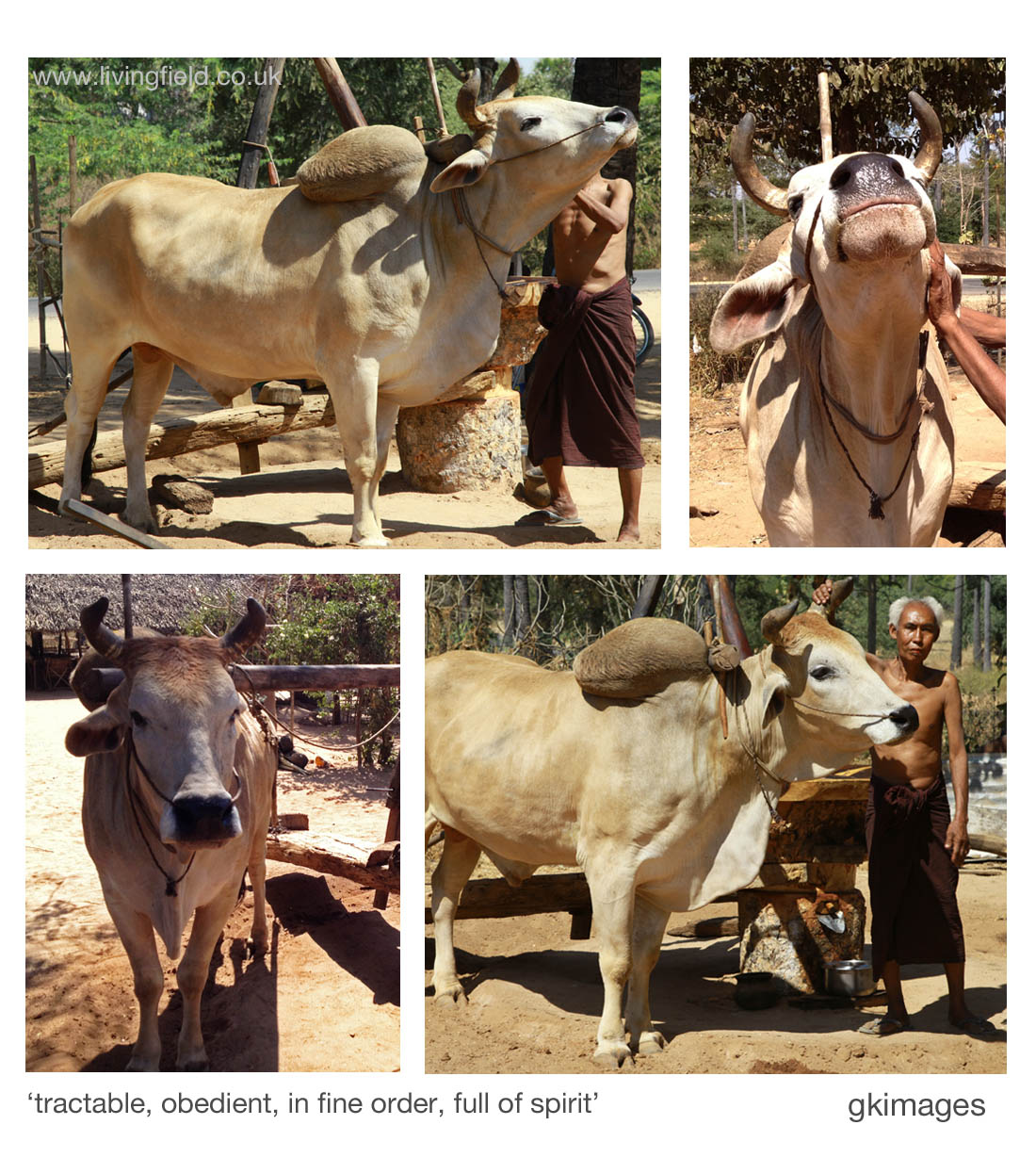
He notes “Oxen only are employed both in cart and plough. I rejoiced to see six yoke of oxen in six carts, pulling along great loads of stones, perfectly tractable and obedient to the driver. They are all in fine order, and full of spirit. They begin labour at five in the morning, and continue till nine. They are then put upon good pasture, or fed with cut clover, till two; when a bell is wrung, and all are ready in an instant for labouring till six in the afternoon.’
At Invergordon, he comments on seven crops: “wheat on this strong land was very good; barley after turnip excellent; beans and peas are never neglected in the rotation; oats in their turn make a fine crop; the old pasture grass excels.”
Agriculture, manufactures and commerce, the pillars that support the nation
Several pages are devoted to the contribution of George Ross of Cromarty, MP a man of “enterprising and comprehensive genius”. He started a hemp manufacturing company employing many people and exporting coarse cloth to London and then a brewery for strong ale and porter, much of it “exported to Inverness and other places by sea-carriage”.
On Ross’s agriculture: “it is wonderful to see barren heath converted into fertile cornfields; clover and other grasses rising luxuriantly, where formerly not a blade of grass was to be seen; horse-hoed turnip, and potatoes, growing on land lately a bog; ….. hay, not known here formerly, is now the ordinary food of horses and cows”. He also cures and exports pork: “… he carried me to a very large inclosure of red clover, where there were 200 hogs of the great Hampshire kind feeding luxuriously.”
Ross works on a plan for improving the harbour and entertains “sanguine hopes that government will one day establish a dry dock near the harbour for repairing ships of war in their northern expeditions.”
Ed: Writing in 1810 after Ross’s death, Mackenzie (1810) states that the hemp trade was “now in a flourishing state. From (the year beginning) 5 January 1807, there were imported 185 tons of hemp; and about 10,000 piece of bagging were sent to London”. Ross was not so far off in his hopes for ship repair – Mackenzie refers to a ship being built there in 1810, and today there are deep anchorage and rig maintenance.
Eight fields, eight crops in sequence
Later on page 257, Wight comments on Mr Forsyth of Cromarty who manages a small farm divided into eight fields, and cropped as follows: “First potatoes, horse and hand hoed, with dung; second, barley; third, clover; fourth, wheat; fifth, peas; sixth, oats or barley, with grass seeds; seventh, hay; eighth pasture. … in this way ‘kept in excellent order, with the advantage of dung from the village”.
Throughout his journeys, Andrew Wight speaks his mind, always ready to praise good farming and condemn poor practice. (You can sense these journeys are more than a job.) And while he accepts the social divides of the time – he was commissioned by the wealthy – notably between the landed gentry and their peasants, he condemns those of the former who ignore, ill treat or exploit and praises those who support and encourage the people to improve their lot by agriculture, manufactures and commerce.
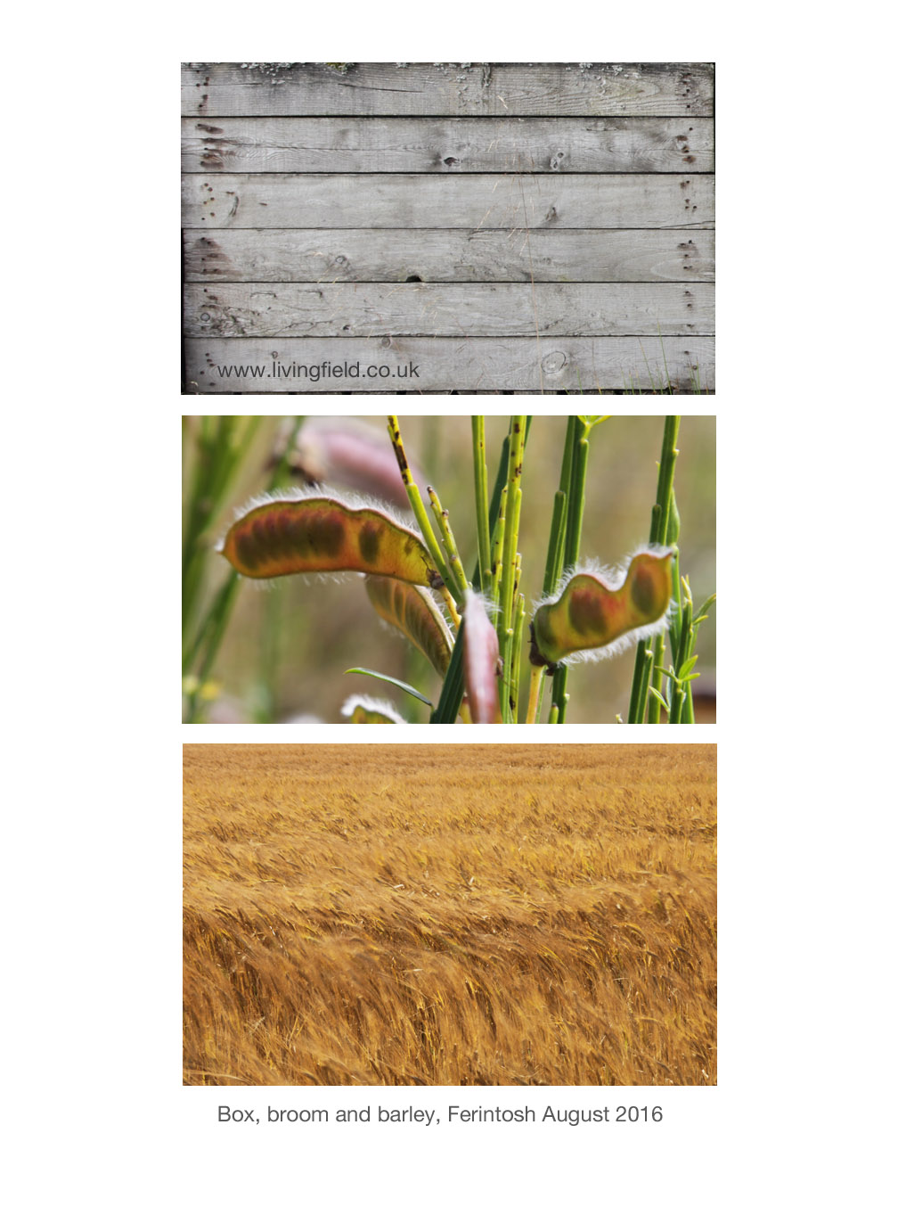
Other points to note are that legume crops (fixing nitrogen from the air) were common in crop rotations and that bere and barley are both mentioned but no clear distinction is made between them (see link to the Bere line below).
Mackenzie, G S. 1810. General view of agriculture of the counties of Ross and Cromarty. London: Phillips.
Wight, A. 1778-1784. Present State of Husbandry in Scotland. Exracted from Reports made to the Commissioners of the Annexed Estates, and published by their authority. Edinburgh: William Creesh. Vol IV part I. (See Great Quantities of aquavitae for further reference and web links).
Those in the upper set were taken of the Foulis Store-house and its surrounds on a visit in August 2016.
There were no ‘yoke of oxen’ around Foulis and Novar in 2016, so the Living Field acknowledges with thanks use of photographs from Burma (Myanmar) by gk-images, taken February 2014 (permission granted by the handler to take the photographs). The quotes below the images come from Wight’s text of 1784, and apply well to this magnificent animal).
Maps of potato. legumes and vegetables in the region in the twenty-tens (and the relevance of this land over the last 2000 years?): Can we grow more vegetables?
Bere and barley both named in Andrew Wight’s journeys of 1778-1784. Bere as the substrate for aquavitae. Bere as a nurse for grass. Bere seed maintaining its mass to volume ratio. Bere fertilised with seaweed.
Andrew Wight, a farmer from East Lothian was commissioned to undertake a series of tours in the late 1700s to examine and report on the state of agriculture in Scotland. His work was published anonymously between 1778 and 1784, but is invariably referred to by his name, and quite rightly, since it was a major undertaking and the best single guide to the state of agriculture during the long ages of improvement (reference below).
He travelled by horse to mainland areas, meeting farmers, tenants and landowners and noting the improvements, or lack of them, to husbandry .
Throughout he refers to both barley and bere, sometimes in the same place, which suggests he considered them different things, presumably bere being the 6-(or 4) row types and barley the 2-row.
He related many anecdotes about bere. Here are a few of them on the journey north from Inverness to Sutherland.
Great quantities of Aquavitae, Ferintosh distillery, Black Isle
He visited the area around Ferintosh, on the Black Isle, owned by Forbes of Culloden. Ferintosh was …. “famous for the great quantities of aquavitae made there under exemption from duty. I am told that there are no fewer than 1000 distillers in that place, wholly occupied in making spirits, utterly neglecting their land, which is in a worse state than for many miles around”. He goes on to write “great quantities of bear are imported from the neighbourhood, and malted there as Ferintosh bear: Not only so, but quantities of aquavitae made elsewhere are carried to market as Ferintosh”. [Ninth Survey Vol IV.I, p. 238].
Of those areas supplying the distilleries was Fowlis, which ‘ .. near the Cromarty Firth has access to seaweed and lime is imported from Portfoy … and bear finds a ready market at Ferintosh.” [p 239]
So you can imagine all these bear harvests from all around, going, not into mouths of people and animals as meal, but to distilleries at Ferintosh, and whisky coming out for export; and everyone so involved in making the stuff that the land went to waste.
But these days bear grain contributes to only a few specialist malts. Most are made from two-row barley.
Wight implied that exemption from duty was granted as a monopoly to that particular estate before the Union, and became ‘destructive to fair trade’ and ‘the occasion of manifold frauds’. Back-handers and dodgy labelling – what’s changed? But the distillery went out of business in around 1785, presumably because other distillers complained abut the unfair exemption.
Bear as a nurse crop for grass
At Invergordon, he writes …. ‘Wheat on this strong land was very good; barley after turnip excellent; beans and pease are never neglected in the rotation; oats in their turn make a fine crop; but above all, the old pasture excels. Later, at the same place, he tells of a method used to protect new-sown grass pasture.
The farmers anticipated a demand for hay or grazing the next year that current grass fields could not supply. So what could they do? They could sow more grass late the present year (September), but what could be done to avoid the seedling grass being damaged over the winter. The solution was to sow grass (which then included various legumes and ribwort plantain with rye-grass) and then … he related….
‘Three firlots of bear were sowed at the same time upon the acre, intended as a cover for grass during the winter …… The bear grew vigorously, and covered the surface during the severe months, but died away on the approach of warm weather.’ The bear seed was sacrificed, it seems, to solve the problem ‘when grass-feeds must be sown in the wrong season’. [Ninth Survey, Vol IV.I, p. 248-250]
Bere fertilised with seaweed
Repeatedly, the writer points to farmers who use lime or marl to reduce acidity, and dung to replenish nutrients taken from the soil by previous crops. Soil fertility was probably the major limitation to maintaining yield.
At Lochbeg, Sutherland, about Mr Gilchrist, the proprietor, he writes “His mode of cropping is one half (the land?) under bear, manured with sea-weed, which is spread on the ground directly, and mixed with soil in spring in two ploughings. Three firlots sowed yield seven bolls per acre.” [Ninth Survey, Vol IV.I, p 307].
Bere seed maintaining its mass to volume ratio
On the Route Homeward, he calls in at Castle Grant. “One thing is extremely remarkable with respect to bear on this farm. Though, time out of mind, no feed has been used but what is produced in the farm itself, yet it never degenerates. To this day a boll of bear, measured by a firlot of 32 pints weighs 20 stone Amsterdam’. And he goes on to write that it degenerates every where else after three or four years sowing, ‘Yet this country lies high, and the climate is cold and stormy.’
An uncertainty in interpretation here seems to be what is meant by the word ‘degenerates’. All cereal harvests consist of grain (seed) that is used for food or sale and the supporting and protective ‘stuff’ around the grain – the stem, the spiky awns, the coverings. A good harvest has a high proportion of grain to all the rest. But grains will only grow to their full extent if they have enough nutrients from the soil.
We have noticed in the Living Field Garden, where bere and other cereals are maintained by saved seed, that the plants might put out all the supporting and protective materials, but if nutrients are short, then the grains do not fully fill. The resulting harvest is not heavy per unit volume of material.
A crucial feature of the bere on the estate that Mr Wight refers to seems to be that the ratio of volume to mass of grain (firlots to Amsterdam stones) is maintained over time. The heaviness does not decline presumably because soil nutrients removed by the crops are replaced by nutrients from elsewhere on the farm and this happens ‘time out of mind’.
This may be a case of highly effective, scientific, nutrient management centuries ago – before labs, remote sensing and intelligent machines.
Farewell Mr Wight
And he writes a farewell to Volume IV.I: “Having now no ground to survey, and having been long out, I proceeded with the utmost expedition homeward, to make up the loss that my absence occasioned in my private affairs.”
Many thanks Mr Wight!
[There will be more from Andrew Wight in future notes on the Bear line – rhymes with hairline].
Sources, references, contacts
Wight, A. 1778-1784. Present State of Husbandry in Scotland. Exracted from Reports made to the Commissioners of the Annexed Estates, and published by their authority. Edinburgh: William Creesh. Vol I, Vol II, Vol III Part I, Vol III Part II, Vol IV part II, Volume IV Part II. All available online via Google Books. With thanks.
Ayrshire in the age of improvement. Contemporary accounts of agrarian and social improvement in late eighteenth century Ayrshire. 2002. Edited by David McClure. Published by Ayrshire Archaeological and Natural History Society. [The introduction gives background to Andrew Wight’s mission and journeys.] Available online.