Inverness Botanics

From our correspondent …

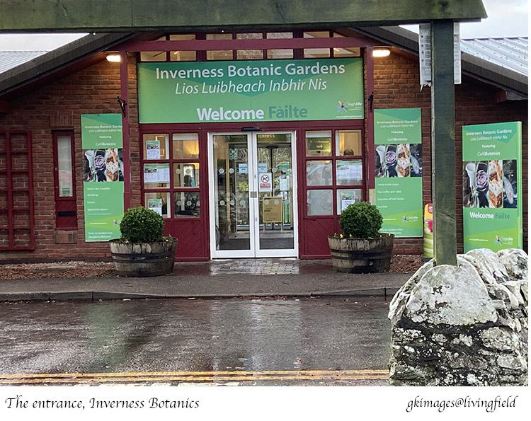
In Highland Region, at latitude 57.46 N, in a cool temperate climate, lies Inverness Botanic Gardens [1]. It combines in its small space, education and community growing with displays of local and exotic plants …. and a cafe .. CafeBotanics. It lies on the west side of the River Ness, just south of the town centre and close to the new southern ring road.

Pass through the cafe, enter the glasshouses and marvel at the collection of tropical plants. Follow the signs along a path to the community hub – the G.R.O.W project – which practices horticultural therapy. There’s grass to play on, a collection of herbs and vegetables and an outdoor insect-house. 

Two cactus plants: details of Cleistocactus strausii (left) and Echinocactus grusonii at Inverness Botanic Gardens. mid-October 2022 (www.livingfield.co.uk).

The garden was opened in 1993 and revamped in 2014 [2]. It’s now open to the public every day each week, admission free, donations welcome.

The Living Field appreciates the blend of education, outreach and botany. But first – and especially for those who haven’t yet visited the region – some notes on the local climate. Is it warm and sunny enough for a tropical glasshouse?

The Climate (outside)

57N has a reputation in the UK – cold and gloomy, cloud and wet! Not at all! Weather is relative – it depends what you are used to and what you mean by gloomy …. and wet. From spring to autumn, there’s plenty of solar income, warming the ground and giving plants the energy to grow, and providing what is, by many standards, very good growing potential.

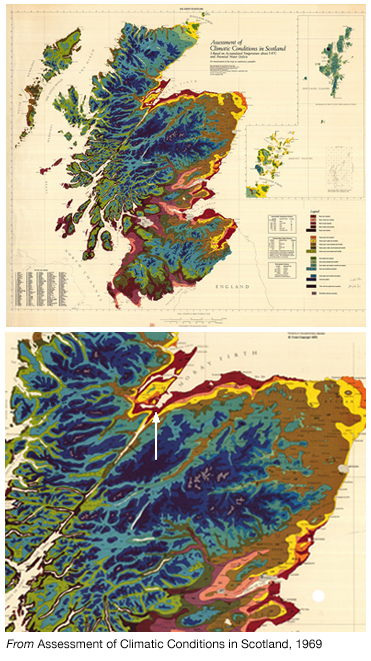
Fig. 1 Map from Assessment of the Climatic Conditions of Scotland produced 1969 by the Macaulay Institute for Soil Research, now the James Hutton Institute [3]. The white arrow in the lower selection points to Inverness. The red zone is the warmest.

Good growing conditions? Yes, providing there is enough rain to wet the soil but not drown it (which there is) and the soil and air are warm enough to allow plants to thrive and survive (which they are). 

The average air temperature in the main summer months is usually 13-14C. The average daily minimum in winter months is just above zero. And while temperature usually falls below zero on several days each winter, there is rarely the prolonged, deep cold of winter farther inland. In the map in Fig. 1, Inverness Botanics lies within the warmest climatic zone – the dark red and yellow areas that fringe the eastern coast.

Details of a fan palm and a north american pitcher plant, lower images in reverse to show structural detail, at Inverness Botanic Garden, mid-October 2022 (www.livingfield.co.uk)

The equable climate is determined mainly by a high solar income over the summer months and proximity to the nearby firth and sea which moderate temperature so it is rarely too cold or too hot.

The graph of daily solar radiation received at the earth’s surface in 2021 (Fig. 2) shows the summer peak and winter low, but also the great day to day variation caused by cloud. The average around the winter solstice in December was about one-tenth of that around the summer solstice in June.

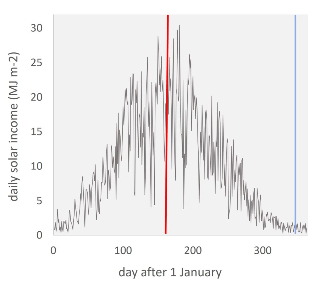
Fig. 2 Daily solar radiation received at the earth’s surface, at Kinloss near Inverness, from 1 January to 31 December 2021, vertical lines at the summer (red) and winter solstice (blue) [4].

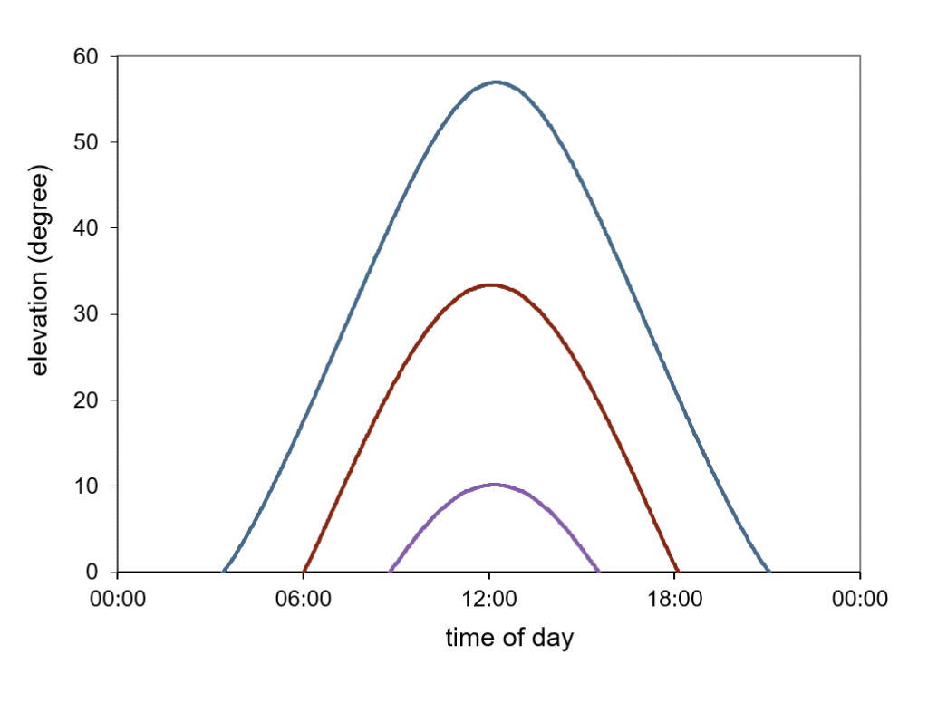
The annual solar variation is linked to both the change in daylength (Fig. 3) and the low elevation of the winter sun. It’s the winter low in Fig. 1 that would make for very cold temperatures in December to February at this latitude if the place was in the middle of continental Europe rather than by the sea.

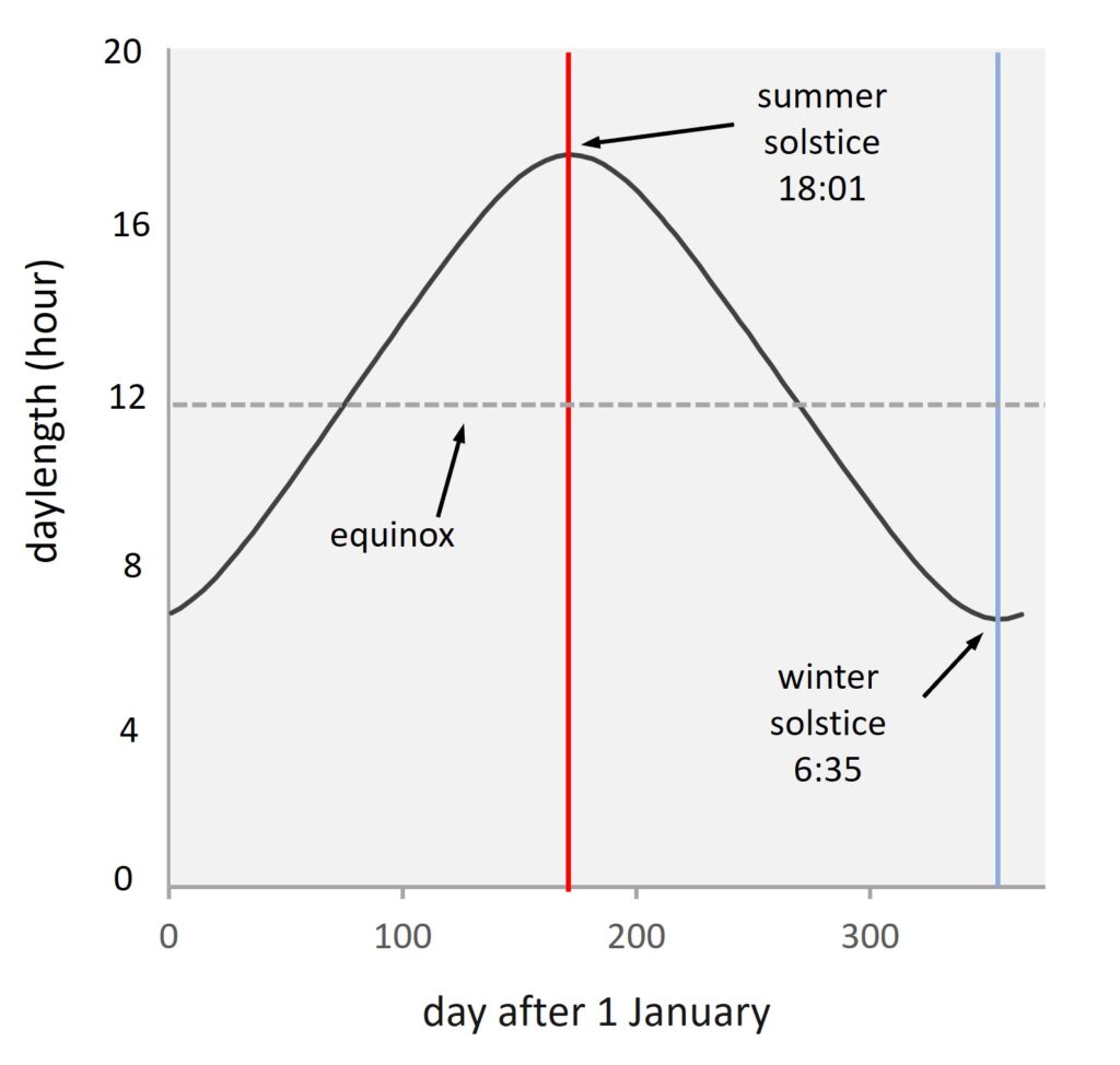
Fig. 3 Change in daylength through the year from 1 January to 31 December at Inverness, 57.46 N, vertical lines as in Fig. 1, horizontal dashed line drawn at the equinox, hours of daylength at summer and winter solstice indicated [4].

But can the area support tropical rainforest?  Not quite (not yet!), but Inverness Botanics lets you feel what it might be like. 

In the cactus house, Inverness Botanic Gardens, taken late July 2022 (gkimages).

The Glasshouses

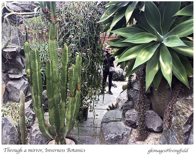
Inverness Botanics houses a diversity of tropical and sub-tropical plants, all viewable from short walkways, some elevated so you can look down at the tops of small palms and plantains. Rock piles, stone walls and big mirrors partition the space making it feel secluded and personal. A few seats and benches give people a chance for quiet contemplation, immersed in the tropical warmth. 

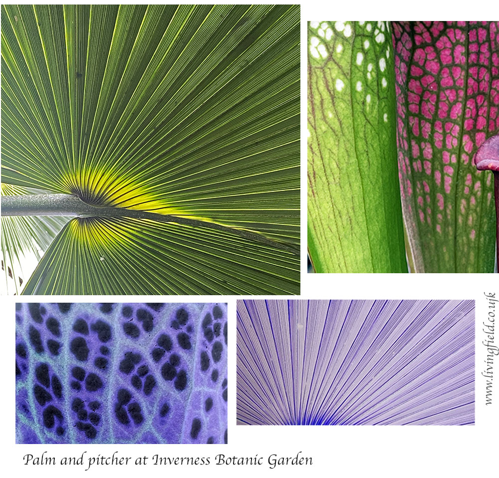
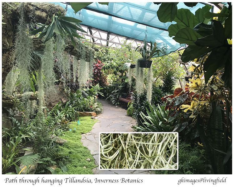
The moist tropical section also has several types of epiphyte – plants that grow on on other plants, but are not parasitic, instead taking nutrients from the water falling on them and their host. Tillandsia usneoides, from south and central America, is one of them, forming a hanging mass of stems bearing short thin leaves. It was good to loiter here – brought back memories of tropical rain forest. 

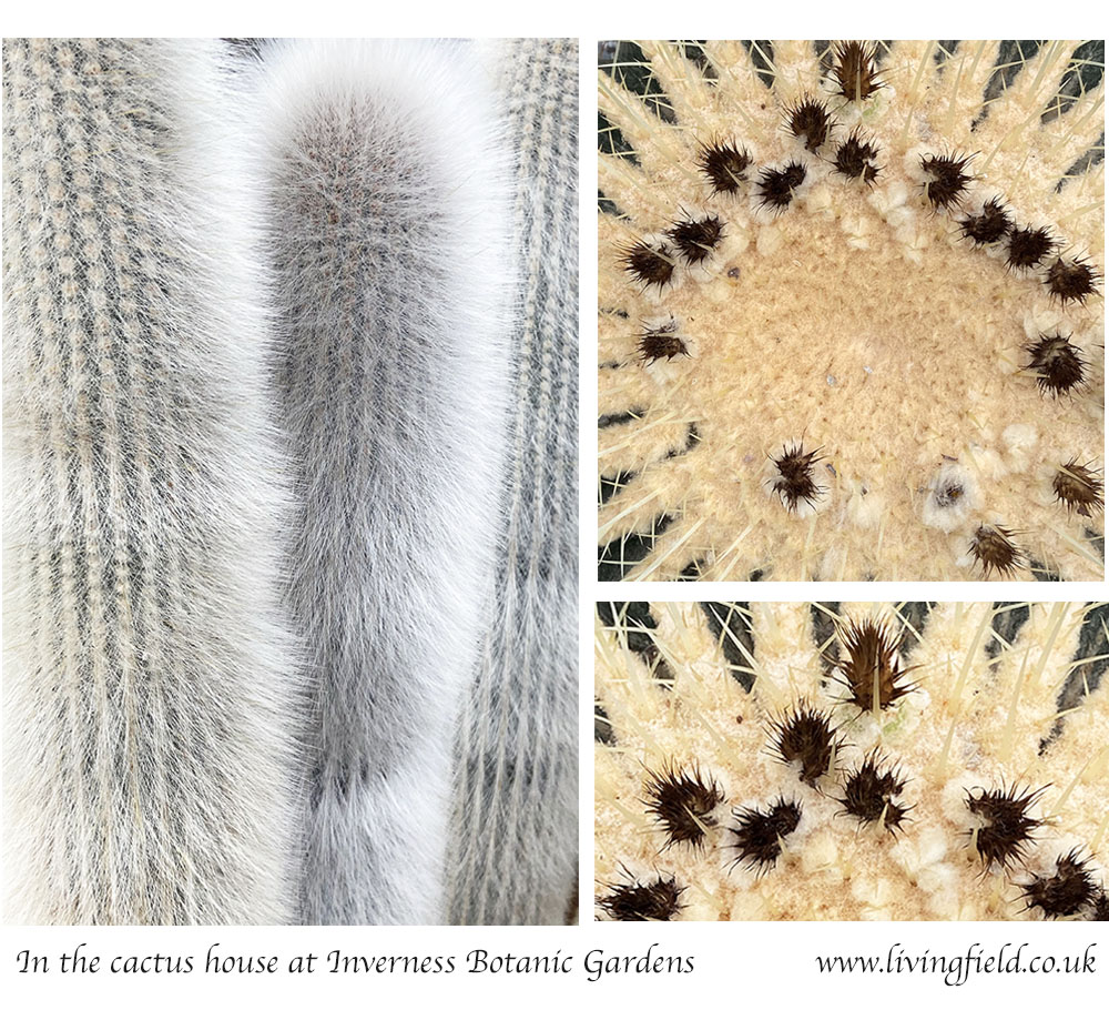
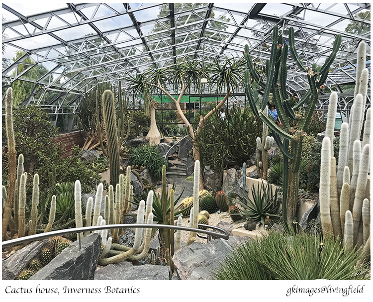
Past a bench of pitcher plants and into the cactus house, displaying a stunning range of shape – tall, thin and hairy, round and prickly. You can’t miss Cleistocactus straussii, native to high mountainous regions in Bolivia and Argentina. A note next to the plants says it can withstand temperature down to 10C, and survives the winter with little water. (Couldn’t live in the Highlands then!) Near to it are the prickly orbs of Echinocactus grusonii, from Mexico. 

Go out of the glass, find the path and follow the signs to …..

The GROW Project

The Garden’s web pages explain: “…. an opportunity for practical horticulture for adults with a learning disability. GROW stands for Garden-Recycle-Organics-Wildlife …. The GROW Project provides a sympathetic workplace-type environment that uses horticulture therapy to deliver training and work experience ..…”.

This part of the garden was well occupied on the day of our visit in mid-October, families wandering, children looking at things – an easy relaxed atmosphere .The flowering season was over for most species but earlier in the year: “… you will find fruit trees, vegetable plots, wild flowers, bulbs, herb beds, a bug hotel to encourage insect life, and much, much more. For children the wooden bears at the tee pee and Jungle Path are looking forward to welcoming you!”

Tree fern, insect residences, stack of cross cut tree trunk and fish pond, the first and last under the glass, at Inverness Botanics, December 2022 (www.livingfield.co.uk).

G.R.O.W. has won formal support from public and private funds, including over £20k in 2021 from the Inverness Common Good Fund to buy around 50 m of raised beds to give people a comfortable working height [5]. The food produced by G.R.O.W is sold on site or else donated to Inverness Foodstuff [6].

Volunteering

Here’s an extract from the Garden’s web pages …

“Our volunteers play a vital part in many aspects of the smooth running of the Gardens. Over the last few years they have spent many hours on the various tasks to assist our gardeners. Inside and outside they help with many horticultural tasks and maintaining our woodwork, paths and glasshouses.”

Follow the links below for more information about becoming a volunteer.

The blog from Marr Communications gives  more on the history, activity and aspirations of G.R.O.W and the Botanics [7].

The hanging threads of the epiphyte Tillandsia usneoides consist of many short thin leaves on long stems (inset) taken late July 2022 (gk images).

Links

[1] Inverness Botanic Gardens and Cafe Botanics at visitinverness and highlife highland. Quotes in the text are from these web links. The Garden also has a facebook page: search @invernessbotanicgardens

[2] On BBC News, 15 January 2014: Inverness floral hall to be branded as botanic gardens. And more information at Britain Express.

[3] Birse and colleagues, working from Aberdeen in the 1960s, produced three stunning maps of the climate in Scotland: Birse EL. 1971. Assessment of the climatic conditions of Scotland. Soil Survey of Scotland: Macaulay Institute for Soil Research, Aberdeen (now the James Hutton Institute). The first of the maps – on temperature and rainfall – is used here to indicate the relatively mild climate of Inverness compared to much of the surrounding land.

[4] Sources of data: for solar radiation, location Kinloss – Centre for Environmental Data Analysis CEDA; for daylength, location Inverness – Time and Date. Graphs constructed by www.livingfield.co.uk. The Living Field web has several articles on solar radiation and climate, e.g. Solar income.

[5] The Highland Council, 15 December 2021: Huge donations to help project GROW – describes what will be done with funds from the Inverness Common Good Fund and HSBC Bank.

[6] Inverness Foodstuff at Ness Bank Church.

[7] Marr Communications: Growing more than just plants.

Ed: thanks to our correspondent for their note on Inverness Botanics and photos taken during visits in July, October and December 2022, examples of which we use on this page

[Update: some minor editing and rearrangement of figures on 24 December 2022]

Through the Solstice

The winter solstice is the period around the shortest day, 21 December [1]. It is a turning point in the annual solar calendar. In the tradition, the winter solstice is a time of renewal, the turning of the year.

Today in northern latitudes, midwinter is a time of family and festivals. Food is in the shops, much of it imported from a global food system. Yet midwinter was very different 5000 years ago in the late neolithic when the early settlers to these islands began to farm. They could not import: they had to grow their own or go hungry.

The arrival of the solstice reminded them how long they had to last on stored grain and livestock. They could add to their diet from wild harvesting and hunting, but once people had committed to a settled existence, they needed grain and grass to ensure their survival.

Three more months at least before the soil was warm enough to sprout fresh grazing and germinate sown seed to give next year’s grain. This lag between the annual cycles of solar radiation and temperature is a defining feature of agriculture in the north. Farming has to cope with it now, as then [2].

They first farmers built great stone monuments to help them follow the solar and lunar cycles. Some, such as at Maes Howe in Orkney and Balnuaran of Clava near Inverness, were designed to mark or to celebrate the winter solstice [3].

Fig. 1 Daylength at the winter solstice, 21 December, at a range of archaeological and historical sites. Hours:minutes shown are from sunrise and sunset tables for 2020, excluding twilight [4]

Daylight hours

When neolithic and bronze age people were making their way across Europe, they experienced the large change in the length of day and night from south to north (Fig. 1). For example, daylength at the neolithic site of Carnac in Brittany (8:26) is two hours longer than at Callanish on Lewis (6:24). At the northern tip of Shetland, it is 5:40 and much farther north in Iceland, around 4 hours.

The length of day determines what can be done outside without torches and street lights. The order reverses in summer – much more daylight in the north than south. The effect of the latitudinal change on life and lifestyle was (and is still) huge, but the early settlers balanced one thing against the other. They crossed dangerous seas to settle and survive throughout the range of daylength, including areas that even today seem remote to most city people.

The standing stones at Brodgar and Stenness, in the Heart of Neolithic Orkney, lie close to the Maes Howe chambered cairn, whose entrance passage is aligned with the setting sun at the winter solstice. [3]
Sunrise, sunset and the three twilights

It would be difficult in most years, even with the aid of aligned monuments, to tell exactly when the shortest day had arrived. Daylength changes very slowly in mid to late December, and the position of the sun is often obscured by cloud or mist. Two other factors make the estimation more difficult – twilight and the shortest day not coinciding with the latest sunrise or earliest sunset (Fig. 2).

Light from the sun is still visible even after it dips below the horizon. This is the time of twilight, of which there are three divisions – civil, nautical and astronomical. The boundary between them is defined by the angle the sun (below the horizon) makes with the earth’s surface [4]. Most people sense night has fallen near the end of civil twilight, but under a cloudless sky it is also possible to ‘see’ well into nautical twilight.

Fig. 2 Change in length of the day and types of twilight (civil, nautical and astronomical) for 40 days either side the shortest day (SD) on 21 December. The earliest sunset (e ss) is about seven days before SD and the latest sunrise (l sr) 7 days after SD. Location: Inverness, latitude 57.5 north.

Civil twilight at the winter solstice varies with latitude less than daylength. For example, it ranges from about 40 minutes at Silbury Hill in Wiltshire to about an hour at Funzie Girt in Shetland .

There is also the complication that the latest sunrise and earliest sunset do not coincide with the shortest day (Fig. 2). The reasons are complex and depend on the axial tilt of the earth and its elliptical (not circular) trajectory round the sun [5].

The photograph above shows two trees on the Hutton Farm near Dundee in 2010. It was taken after the end of civil twilight and well into nautical twilight. The original image was almost black, but shape and colour were revealed by digital processing.

Solar elevation and the sun’s intensity

The growth of crops and grass depends on the amount of solar energy reaching the earth’s surface rather than on the period of light. Daylength has an effect – it determines when some plants change their state, for example from vegetative to reproductive – but plants put on mass by capturing solar energy and using it to process carbon dioxide from the air into living matter.

The incoming solar energy increases from winter to summer solstices as a result of both increase in daylength and increase in the sun’s ‘height’ in the sky, defined as its elevation or altitude [Fig. 3]. Between winter and summer solstices, daylength increases about 2.6 times, while the sun’s elevation or altitude increases 5.6 times. (These values change with latitude – those cited are for Dundee near latitude 56N.)

The combination of longer days and rising altitude causes a 20-30 times increase in the incoming solar radiation reaching crops, grass and forest between the winter and summer solstices [6]. This, and the annual changes in temperature and rainfall, are the major factors that determine which types of crop and grass grow here, the times they can be planted and harvested and the yields they can attain.

Fig. 3 Diagram to show the changes through the year in the rising and setting of the sun and its elevation or altitude at latitude 56N. The horizontal axis shows the time of day, the vertical axis the elevation or altitude of the sun (90 degrees would be directly overhead). The lower curve is for the winter solstice, the upper for the the summer solstice and the middle for the equinoxes [6].

Contact | author: geoff.squire@outlook.com or geoff.squire@hutton.ac.uk

Sources / links

[1] The winter solstice is defined in astronomy as a particular time on usually 21 December, but it is also used widely to mean the period of several days around the shortest day.

[2] Living Field web pages on The Year describe the changing annual cycles and their importance for farming and food production.

[3] Maes Howe, Orkney: Orkneyjar; for archaeological detail, Canmore; to see the solstice, Maeshowe webcam site. Balnuaran of Clava: Historic Environment Scotland; Canmore. See also the Winter solstice on the Living Field site.

[4] Daylength, twilight times and solar elevation are available online for almost anywhere on earth. One of the easiest web sites to use, and the most informative, is timeanddate.com – insert a named place where indicated to see daily data tables; once there, you can use the map facility to find any place. Try also NOAA Solar Calculator provided by the US Global Monitoring Laboratory.

[5] For explanation of the earth’s tilt and solar trajectory, try: Articles about Sun at timeanddate.com; a BBC Weather page; the explainingscience blog. For a thorough and authoritative account: Szokolay S.V. 1996 (rev 2007). Solar geometry. Passive and Low Energy Architecture International (PLEA) and Department of Architecture, University of Queensland.

[6] The Living Field article No Life Without the Sun gives further explanation of the effects of daylength and solar elevation on the changes in incoming solar radiation throughout the year.