Fit Farming in the 1770s

The exhibition – Farming Fit for the Future – at Alyth Museum [1] in Perthshire shows how some farmers in Strathmore are regenerating the health and productivity of their land for a sustainable future.

[In progress – liable to editing 7 August 2024]

Agriculture here has a history of several thousand years. It has been through many cycles of decline and renewal. Some of the most effective changes in recent centuries – the Improvements – were introduced over several decades followed a devastating run of severe weather and resulting privation in the 1690s. The state of agriculture was later documented by farmer Andrew Wight on journeys beginning 1773 around mainland Scotland [2].

The Living Field looks back 250 years to the time of Mr Wight’s journals. What did he see as the main innovations or improvements in this part of Perthshire and Angus and how do they compare to the changes in land management described at the Alyth exhibition?

First – a look at the extent of managed agricultural land today, in Strathmore and beyond.

areaS of arable and managed grass TODAY

The agricultural census [3] records the area of land within several broad catagories. Arable or tilled land is typically ploughed and sown with cereals and other annual crops such as oilseed rape, potato and vegetables. Grassland, managed as grazing or hay for livestock, is separated into short-term (grown for less than 5 years) and long-term grass. A third broad category and the largest area, known as ‘rough grazing’, occupies mainly higher ground including the lower slopes of the hills. The main areas of production are the arable and managed grass.

Fig 1. Areas of arable land and managed grass (green colouring) in the early 21st century [4]. The dashed line shows the approximate position of the Highland Boundary Fault.

These categories are not permanent. Traditionally, and today still in some areas, short-term grass is sown as part of an arable-grass sequence. Also, land can switch between arable and grass – for example, large areas of arable land were moved into grass as recently as the 1980s and 1990s.

Arable crops and grass are cultivated mainly in low-lying regions to the east and south of the country, but they extend to parts of the far west and north (Fig. 1). For the western islands and much of the west mainland, thin strands of agricultural fields trace the boundary between land and sea.

At the east-centre of the mainland, the cultivated land is delimited by the Highland Boundary Fault (approximated by the dashed grey line in Fig. 1). Arable and grass occupy lower elevations to the south of the Fault. Rough grazing and non-agricultural land extend to the north. The climate and soil to the south of the Fault support a diverse agriculture which by global standards is highly productive.

Strathmore runs north-east from just above Perth, towards Alyth and on to near the coast. The Living Field post – Can we grow more vegetables? [4] shows the topography and boundaries of the strath, while Feeding the Romans [5] describes the line of watch towers, forts and fortresses that the invaders built just south of the Fault.

Figure 2. Arable and grass fields in productive land mostly to the south of the Highland Boundary Fault (see Fig. 1) in Perthshire, Angus and Fife. Letters show (D) Dundee, (P) Perth, (A) Alyth and (M) Montrose. Coloured dots indicate centres of fields growing mostly arable (dark grey) and grass (light purple).

North of Alyth on Fig. 2, it looks as if the productive land in Strathmore is putting out ‘feelers’ – testing the conditions in the expanse of unproductive white. But these thin strands are formed by fields immediately adjacent to the rivers that flow down through steep sided glens (valleys) across the Fault and into Strathmore. The boundary between land and sea is not shown on the map, but the fields define the coastline, including the shape of the Tay estuary between Perth and Dundee.

The copious supplies of water from the north and the rich soil south of the Fault, together with the maritime climate of this region, give Strathmore its great capacity for agricultural production. Farms in the exhibition [1] lie mostly in the arable-grass but some extend to higher elevations.

Improvements by the late 1700s

A major, systematic change in land management in lowland Scotland was stimulated during the 1700s by the ideas and methods of wealthy landowners such as Henry Home (1696-1782) and John Sinclair (1754-1835). They were unsure as to how far their innovations had been taken up by other landowners and their tenants. So to get the evidence, Andrew Wight, himself a farmer, was commissioned to ride around Scotland, visiting innovative farmers and documenting their methods and results. His findings were published in 1778 and 1784 [2].

[To be continued with ….. the course of Mr Wight’s travels in Strathmore, his views on farming’s capacity to change …. ]

Author / contact: geoff.squire@hutton.ac.uk or geoff.squire@outlook.com

Sources | Links

[1] For the exhibition on regenerative agriculture at Alyth Museum – the Living Field post: Farming Fit for the Future.

[2] The Living Field web has several times used Andrew Wight’s records of journeys around mainland Scotland’s farming regions, for example at The Mill at Atholl and Great quantities of Aquavitae. Wight, A. 1778-1784. Present State of Husbandry in Scotland. Exracted from Reports made to the Commissioners of the Annexed Estates, and published by their authority. Edinburgh: William Creesh. Vol I, Vol II, Vol III Part I, Vol III Part II, Vol IV part II, Volume IV Part II. All available online via Google Books. With thanks.

[3] Results of the annual agricultural census are summarised at Scottish Agricultural Census: Results.

[4] The original map, from which Fig. 1 was derived, was constructed by Nora Quesada Pizarro and Graham Begg, working with Geoff Squire, at the James Hutton Institute, Dundee. The original was edited by the author to show approximate areas of managed arable and grass. The background data and the method of constructing this and similar maps by Hutton researchers, have been described on the Living Field web at Can we grown more vegetables. The map in Fig. 2 was constructed from grid coordinates for fields separated into broad categories of arable and grass.

[5] Notes on Roman escapades in Strathmore – Feeding the Romans.

[To be continued …..}

The Garden at Open Farm Sunday 2017

The Living Field Garden was looking good at Open Farm Sunday on 11 June this year.  Despite wet weather, we had over 1000 visitors.

More on the Open Farm exhibits appears at the Hutton Institute’s LEAF web pages. Here we look at some of this year’s plants.
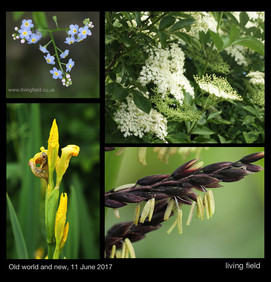
lf_g_ofs17_ldwrldnw_gs_1100
Water forget-me-not (top left, then clockwise), elder flower, close up of male flower on a maize plant, and wild yellow iris.

The hedges are thick with leaf, the hawthorn now filling its haws, the elder and the wild rose still in full flower. Water forget-me-not and wild iris are flowering in the wet ditch, while field scabious, comfrey  and viper’s bugloss are offering plenty for the several species of bumble bees that live in and around the garden.

The east garden’s perennial and arable beds

The three local species in the images above all reside in their own habitats, but are within a few seconds of hoverfly flight to the exotic maize in the arable plot. Maize originated as a crop in the Americas and was unknown in the country before the last few hundred years.
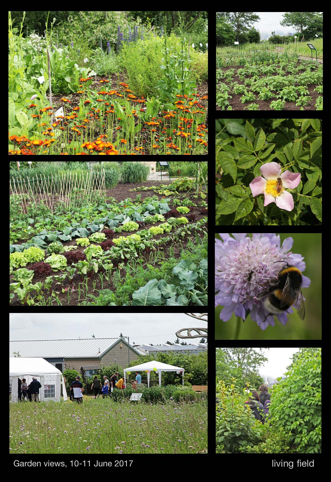
lf_g_ofs17_grdnvws_gs_1100
The east garden (top l, down) across the medicinals bed, the vegetable quarter of the arable, across the meadow, just in flower; (top r, down) the potato patch, wild rose and visitor, bumble be on field scabious, through a gap in the hedge, June 2017

This proximity of the wild and the cultivated is one of the recurring features of the garden. The images above contrast the cropped area of the east garden with the perennial meadow and hedge plants. The  field scabious in the meadow will keep the bees well supplied until late September at least.

Raised beds of the west garden

Through the gate, the west garden’s raised beds are filled this year with vegetables and herbs. There are various cabbages and spinaches, parsley, thyme and dill, companion plantings and intercrops, to name a few, and all are intended to show the very different concentrations of minerals that these plants take from the soil and accumulate in their tops.
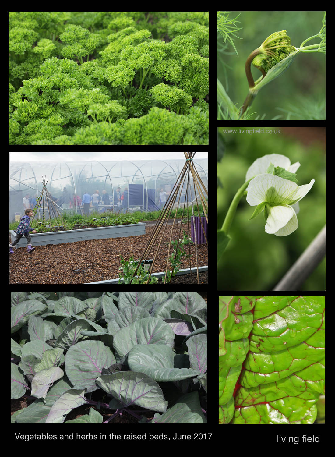
lf_g_ofs17_wstplnts_gs_750
Herbs and vegetables (top l down) parsley, across the raised beds to the polytunnel, cabbage; and (top r down) dill umbel unfolding, pea flower and chard leaf, June 2017

The background and results of this study, which is based on research at the Institute, will be covered in a future Living Field post.

Creepy towers

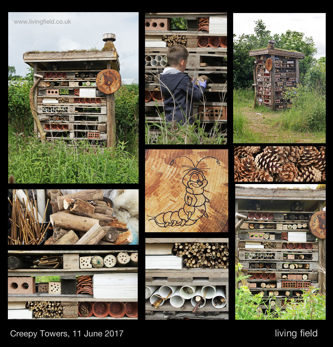
We’ve been constructing various small places for insects and spiders since the garden began, but this year, the idea of a more permanent residents block was made real just before Open Farm Sunday. First stack your pallets, add a roof of turf and fill the spaces with small bespoke homes for our creepy friends.

lf_g_ofs17_crptwrs_gs_1100

Old logs and fence posts, with holes drilled in the ends, pine cones, garden canes, bricks with holes through, tubes, sticks, bits of rotting wood – all make ideal residences.

Exhibits at Open Farm Sunday 11 June 2017

The garden made a return this year as the base for many activities at Open Farm. The cabins hosted exhibits on greenhouse gas emissions and nitrogen fixing legumes. The east garden, as you go in through the gate by the cabins, had a soil pit, cereal-legume intercropping, pest traps and the urban bug house shown above, while the west section displayed heathy vegetables, soil bacteria, our friends from Dundee Astronomical Society and Tina Scopa running a workshop on wild plant ‘pressing’.

The garden was maintained by the usual crew: Gladys Wright and Jackie Thompson on the arable plots and raised beds; Paul Heffel from the farm kept the hedges in trim and cultivated the soil where required; Geoff Squire arranged the medicinals and dyes and kept an eye on various rarities and curiosities.

Gill and Lauren Banks, with help from the farm, constructed Creepy Towers, for which the ‘chimney’ was crafted by Dave Roberts and the plaque by visiting student Camille Rousset.

There is no formal funding for maintaining the garden – it happens through commitment and hard work, often out of hours.

Contact for the garden: gladys.wright@hutton.ac.uk