Burnt whin

The very dry spring of 2017 not only set back crops but prepared moor and rough grazing for fire. These habitats are used to fire.  They have evolved with it as a recurrent destroyer, at least since the last ice retreated and people returned in numbers to begin clearing and cultivation.

The problem for those today concerned about natural heritage is that fire does not discriminate, and while the burning of grass and whin (or gorse) Ulex europaeus will not affect their survival in most localities, it can devastate rare and declining, or even newly expanding, populations of other plants growing along with them.

lf_ntsmgs_frdwhn1_gs_1100

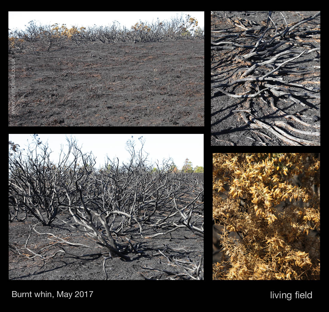
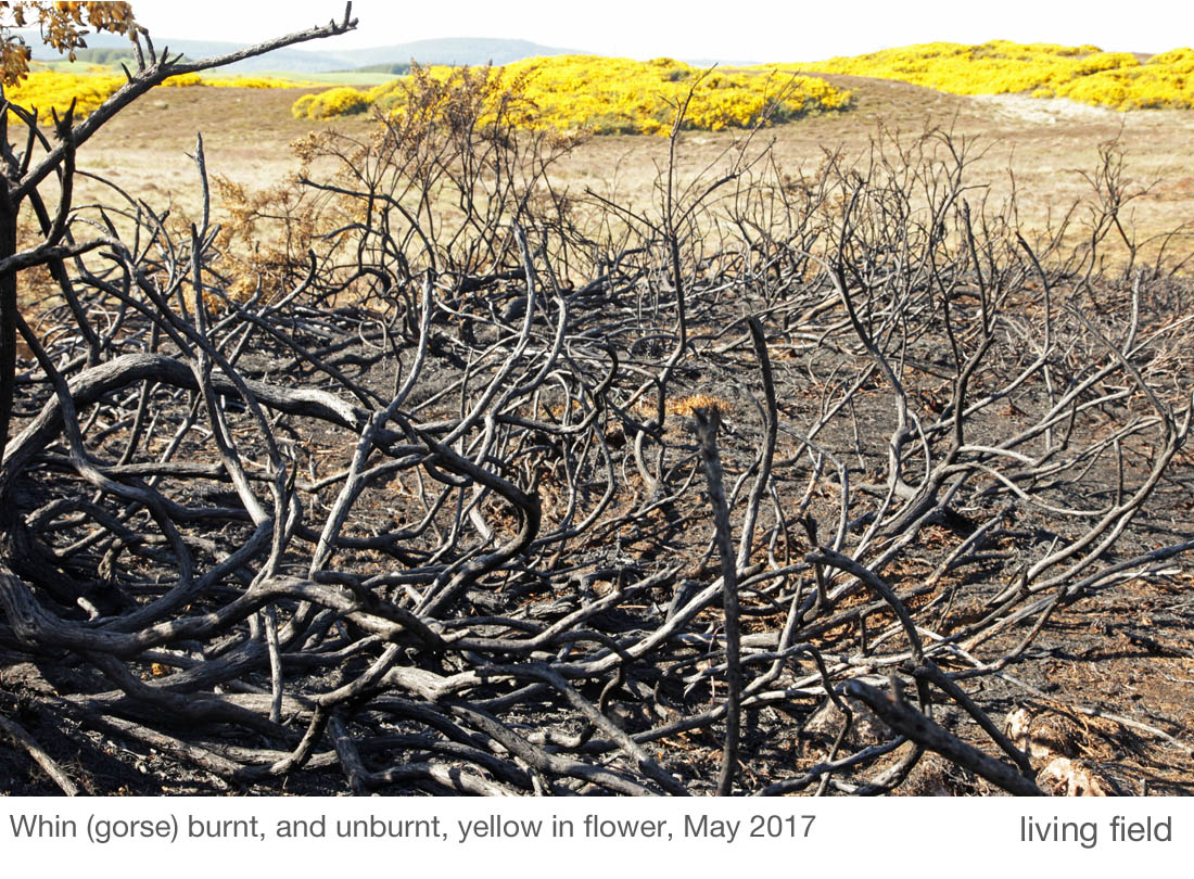
This was the case in pockets of whin-dominated land that were fired during the dry spring. Fire left the whin’s stems and branches like blackened bones. They appear intact, but they disintegrate to powder if you try to pick them up.

The intensity of the fire was so great in places that everything had been burned, but at the edges not all was lost. Flowering branches had been singed in the heat, no longer bright yellow, but perhaps not dead; and some small broadleaf trees such as rowan Sorbus aucuparia had one side singed and the other not.

So what made an ‘edge’ that stopped the fire. In one area, it was a narrow road that the fire did not cross. In another it was wetter ground in a hollow that stopped the advance. (It takes a lot to completely dry out a bog in these parts.)

lf_ntsmgs_frdwhn2_gs_1100
The fire is stopped in the upper image on both sides of a wet depression, and by a small pile of dung (lower left), and did not burn the bones, May 2017 (Squire/Living Field)

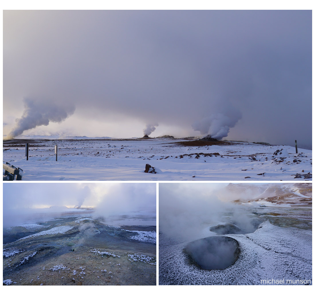
The images above (top) show a wet hollow or depression, which stopped the fire from consuming the willows in the middle ground but not the rough grass before nor the trees beyond.

The fire also failed to take some small areas. One (lower left above) appears to be nothing other than a small pile of droppings (deer?) which presumably was wet enough to prevent the surrounding grass for being blackened.

Threatened juniper

This small fire, covering just a couple of acres (not quite a hectare) would have destroyed any birds’ nests in its way, but it also destroyed juniper and young pine.

Juniper Juniperus communis is particularly vulnerable in many areas of Scotland because it is declining due to a range of factors including over-grazing and disease [1, 2]. The location shown in the photographs, within 10 miles of Inverness,  falls within Zone 1, that of least concern for juniper conservation.

Yet here, even in Zone 1, within an extent of 5 x 5 km (25 square kilometres) juniper exists mainly as isolated mature bushes and some regenerating young plants, not as a complete stand.

lf_ntsmgs_frdwhn_pnjnpr_gs_1100

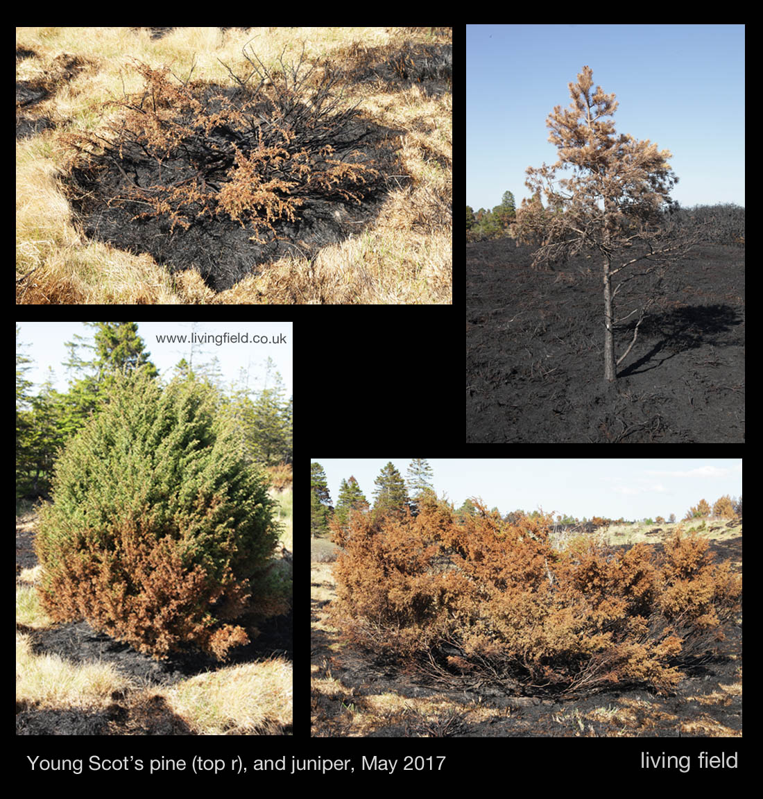
It is heartening to see several young plants in this area [3], but not to see that in this one small fire, some young juniper were scorched to death.

There was evidence that the fire was more intense under and around some juniper (top left above), perhaps because the dead plant matter accumulating under the bushes was more flammable than the surrounding grass? Perhaps there were other reasons.

Also young Scots pine Pinus sylvestris were badly affected. The one top right above was 100 metres from the nearest tall mature native pine tree; and though it looks small, it  could well be several decades old, checked in growth by the poor conditions. It’s a pioneer spreading from a native remnant, but not likely to survive this fire.

This was a very small bush fire by local standards, and insignificant compared to the fires raging over thousands of square kilometres in some parts of the world, but even so it caused a lot of damage to populations of juniper and Scots pine that are struggling to maintain or expand their range.

It may add to the demise of juniper in this region. The fire was probably started illegally by someone.

lf_ntsmgs_whnbrnt_gs_1100

Links

[1] Forestry Commission Scotland. Conservation zones for Juniper. The locality shown in the photographs above is in Zone 1 (self-sustaining juniper populations – conservation management beneficial in some places to promote natural regeneration). See also Species action notes which consider juniper along with black grouse, capercaillie, red squirrel, pearl-bordered fritillary and chequered skipper.

[2] Forestry Commission Scotland. Planting juniper in Scotland: reducing the risk from Phytophthera austrocedrae. Link to Online Guidance.

[3] Scotland’s Nature (Scottish Natural Heritage). Good news for Scotland’s juniper.

Contact/author/images: geoff.squire@hutton.ac.uk

Iceland

Kirstin Buchholz & Michael Munson (photographer) visited Iceland in February 2015.  Here are some of their impressions and images of the places on the route.

In Vatnajökull National Park, Iceland (Michael Munson/Kirsten Buchholz)

Their visit took place during the Holuhraun volcanic eruption (click link for events in February 2015) which began on 31 August 2014.  to the north of Vatnajökull glacier.

Kirsten writes: “When we started off in Reykjavik, it was chilly with 4°C and clear sky. When we reached the Golden Circle, it got colder, windier and we even had snow. Down south, it was about 0°C, windier and lots of broken icebergs from the glacier Vatnajökull in Jokulsarlon. The south and east coast of Iceland reminded us about Scotland’s west coast. The rocks, the maritime climate, the wind, the rain, the seagulls and the snow covered hills, apart from the black sand beach in Vik! …….. “

On the road in Iceland, February 2015 (Michael Munson/Kirsten Buchholz)

“The canyon Jokulsargljufur on our way north to Iceland was impressive – also the weather changed dramatically. The temperature dropped down to -10°C with snow, sleet, hail and rain and very high wind – sometimes all simultaneously! The cloud cover changed by the minute so the chances of seeing the Northern Lights were slim. There were loads of farms, cattle and horses around the south, east and north of Iceland. There are also reindeer, mostly on the east coast.”

Vatnajökull

The Vatnajökull glacier and its surrounds is a National Park, the largest in Europe, notable for its sub-glacial lakes and volcanos concealed under the ice cap. The last eruption was in 1996. It broke through the surface of the ice, emitting an ash cloud 10 km high. The subsequent spectacular release of meltwater caused great damage but increased the land area of the country by 7 square kilometres. There’s more on Vatnajökull at Iceland on the Web.

At Vatnajökull (Michael Munson / Kirsten Buchholz)

Mývatn

… the name of a lake in northern Iceland, which like Scotland was covered in ice during the last glaciation. The region experienced several major volcanic eruptions in recent millennia. One that happened 2300 years ago – that’s the middle of the Iron Age in Britain and the founding of Ancient Messene in Greece – led to the formation of the lake.

The area around the lake is still geothermally active, the images below showing smoke and fumes rising from small craters and holes in the ground.

Geothermal landscape near Lake Mývatn (Michael Munson / Kirsten Buchholz)

Skógafoss and the southern agricultural plain

The farmland of Iceland experiences a form of the ‘northern cool summer’ effect in which the solar income is spread over the long days, encouraging crops and grass to produce a high output. The main farming activity is stock raising.

The southern agricultural plain from Skogafoss (Michael Munson / Kirsten Buckholz)

The waterfall, Skógafoss, is a major attraction of the southern region of Iceland.  The fall is seen to the lower right of the top right image above. Note the red roofs in the left centre of that image – they are seen again at the right centre of the image to the left, which then shows the river flowing from the waterfall through pasture continuing down to the sea in the distance. The lower image taken from  Skógafoss shows the strip of coastal grazing land, between hills and sea.

Þingvellir

And we end with this scene in fading light from Þingvellir. The Þingvellir (or Thingvellir) National Park was  designated by law in 1928 and protected as a national shrine. 

lf_iceland_7_kbmm_1100
Þingvellir (Michael Munson / Kirsten Buchholz)

A general assembly (parliament?) began here about 930 and continued until 1798.

Thingvellir is one of the partner sites in the Thing Project –  a move to coordinate the documentation and history of viking or norse ‘assembly’ sites – Thing sites – in North West Europe. Partners in Britain include organisations and sites in Shetland, Orkney and Highland Region at Dingwall.

Notes, credits

All images copyright of Michael Munson and Kirsten Buchholz. Additional material by GS.

The Icelandic Met Office give a month-by-month account of the Holuhraun eruption at en.vedur.is. The eruption was declared to have ended in early March 2015.


White lily dark dye

The roots of the white water lily Nymphaea alba, extracted from the mud at the bottom of lakes, were once used to dye tweed ‘black, blue or dark brown’, and mixed with leaves to make a poultice (Scots Herbal).

White water lilly on a loch south of Inverness, taken 14 July 2014 (Squire)

Nymphaea alba is striking plant where it finds a place to expand in shallow lochs in open water between patches of reeds and sedges.  The plants in the photographs above were growing in water at least  one metre deep.  They began flowering in early July.  The small catchment that fed the loch had been mixed crops and grazing until the 1980s when it was turned to sheep grazing and sitka plantation. Apart from atmospheric deposition, the only pollutants were from animal dung and the annual sheep dip. Entry and outflow streams are crystal clear.

The metallic sky and water on this day recalled images of Tasek Bera (or Berak ) an inland expanse of water and swamp in Malaysia. Travel was by dugout and accommodation a small tent by the water’s edge: swimming in the dark water, paddling dugouts and exploring pandans,  pitcher plants and white water lilies. At that time, a  system in balance and now a Ramsar wetland site.

Images of Tasek Bera, Malaysia, scanned from 35 mm colour slides taken 1984 (Squire)

The photographs above taken on a visit in 1984  show (top left clockwise) water lilly, a view to the land surrounding the lake, pitcher plants and pandanus growing in the water, plant species uncertain.

More to follow on Tasek Bera.

Geoff Squire

References

Darwin T. 1996. The Scot’s herbal. Mercat Press, new edition 2008 by Berlinn.

Wetlands International web site for Tasek Bera – for information on the lake, plants and people, click the ‘Library’ tag on the site and next to ‘Current publications’ search for Tasek Bera to browse several sources including downloads.